 |
On-line Digital Images |
SC 721373 |
Papers of Helen Cameron Nisbet, geologist and archaeologist, Lasswade, Midlothian, Scotland |
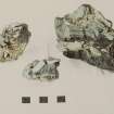
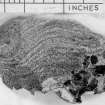
Copy of colour slide showing detail of "agglomeratic" vitrification
Dun Deardail, Glen Nevis; Meall an Iarnuim, Inverpolly; Rubh'Aird Ghamhsgail, Arisaig
NMRS Survey of Private Collection
Digital Image Only |
3/1968 |
Item Level |
|
 |
On-line Digital Images |
SC 723490 |
Papers of Helen Cameron Nisbet, geologist and archaeologist, Lasswade, Midlothian, Scotland |
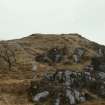
Copy of colour slide showing view of Rubh' Aird Ghamsgail ( Rubh Ard Ghaunsgail) Arisaig.
insc: view of fort from approx N.W.
NMRS Survey of Private Collection
Digital Image Only |
17/3/1968 |
Item Level |
|
 |
On-line Digital Images |
SC 723518 |
Papers of Helen Cameron Nisbet, geologist and archaeologist, Lasswade, Midlothian, Scotland |
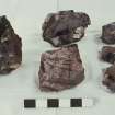
Copy of colour slide showing details of vitrification; showing disruption of blocks and gradation of natural banding into frothy "matrix"
Left: vitrification, Dun Deardail, Nevis;
Top and right: vitrification Rubh' Aird Ghamsgail Arisaig.
Bottom centre: natural xenoliths in pink granite (?Ross of Mull)
NMRS Survey of Private Collection
Digital Image Only |
3/1968 |
Item Level |
|
 |
On-line Digital Images |
SC 723552 |
Papers of Helen Cameron Nisbet, geologist and archaeologist, Lasswade, Midlothian, Scotland |
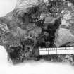
Copy of black and white slide showing detail of vitrification containing woodcasts and glassy droplets
Rubh' Aird Ghamsgail Arisaig, Lochaber
NMRS Survey of Private Collection
Digital Image Only |
c. 1965 |
Item Level |
|
 |
On-line Digital Images |
SC 723559 |
Papers of Helen Cameron Nisbet, geologist and archaeologist, Lasswade, Midlothian, Scotland |
Copy of black and white slide showing detail of vitrification from Rubh'Aird Ghamhsgail, Arisaig.
Vitrification showing fading out of gneiss banding and "embayment" by vesicular patch
NMRS Survey of Private Collection
Digital Image Only |
c. 1965 |
Item Level |
|
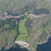 |
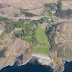
On-line Digital Images |
DP 076688 |
RCAHMS Aerial Photography Digital |
General oblique aerial view of Arisaig House, with the A830 improvement roadworks in the back ground, taken from the SSW. |
31/5/2009 |
Item Level |
|
 |
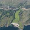
On-line Digital Images |
DP 076689 |
RCAHMS Aerial Photography Digital |
General oblique aerial view of Arisaig House, with the A830 improvement roadworks in the back ground, taken from the SSW. |
31/5/2009 |
Item Level |
|
 |
On-line Digital Images |
DP 076690 |
RCAHMS Aerial Photography Digital |
General oblique aerial view of Arisaig House, with the A830 improvement roadworks in the back ground, taken from the SSW. |
31/5/2009 |
Item Level |
|
 |
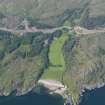
On-line Digital Images |
DP 109053 |
RCAHMS Aerial Photography Digital |
General oblique aerial view of Arisaig House and Borrodale House with the site of Prince Charlie's Cave in the foreground, taken from the SSW. |
30/4/2011 |
Item Level |
|
 |
On-line Digital Images |
SC 2383369 |
Records of the Ordnance Survey, Southampton, Hampshire, England |
Rubh' Aird Ghamhsgail, Arisaig, NM68SE 2, Ordnance Survey index card, Recto |
1958 |
Item Level |
|
 |
On-line Digital Images |
SC 2383370 |
Records of the Ordnance Survey, Southampton, Hampshire, England |
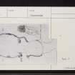
Rubh' Aird Ghamhsgail, Arisaig, NM68SE 2, Ordnance Survey index card, page number 1, Recto |
1958 |
Item Level |
|
 |
On-line Digital Images |
SC 2383371 |
Records of the Ordnance Survey, Southampton, Hampshire, England |
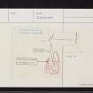
Rubh' Aird Ghamhsgail, Arisaig, NM68SE 2, Ordnance Survey index card, page number 2, Verso |
1958 |
Item Level |
|
 |
On-line Digital Images |
SC 2383372 |
Records of the Ordnance Survey, Southampton, Hampshire, England |
Rubh' Aird Ghamhsgail, Arisaig, NM68SE 2, Ordnance Survey index card, page number 3, Recto |
1958 |
Item Level |
|
 |
On-line Digital Images |
SC 2383373 |
Records of the Ordnance Survey, Southampton, Hampshire, England |
Rubh' Aird Ghamhsgail, Arisaig, NM68SE 2, Ordnance Survey index card, Recto |
1958 |
Item Level |
|
 |
On-line Digital Images |
SC 2383374 |
Records of the Ordnance Survey, Southampton, Hampshire, England |
Rubh' Aird Ghamhsgail, Arisaig, NM68SE 2, Ordnance Survey index card, page number 2, Verso |
1958 |
Item Level |
|
|
All Other |
551 166/1/1 |
Records of the Ordnance Survey, Southampton, Hampshire, England |
Archaeological site card index ('495' cards) |
1947 |
Sub-Group Level |
|


