
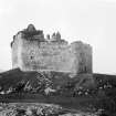
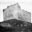
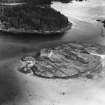
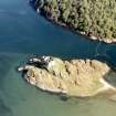
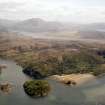
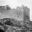
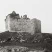
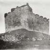
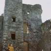
Castle Tioram


Castle (Medieval), Midden (Period Unassigned), Hanging Bowl (Bronze)(Period Unassigned)
Site Name Castle Tioram
Classification Castle (Medieval), Midden (Period Unassigned), Hanging Bowl (Bronze)(Period Unassigned)
Alternative Name(s) Eilean Tirim; Castle Tyrrim; Castle Tirrim; Eilean Tioram; Loch Moidart, Castle Tiorim; Ellan-tirrim
Canmore ID 22511
Site Number NM67SE 1
NGR NM 66211 72431
Datum OSGB36 - NGR
Permalink http://canmore.org.uk/site/22511


- Council Highland
- Parish Arisaig And Moidart
- Former Region Highland
- Former District Lochaber
- Former County Inverness-shire
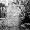
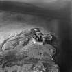
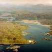
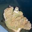
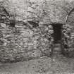
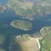
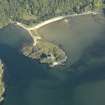
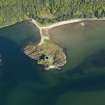
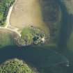
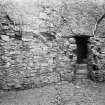
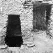
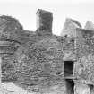
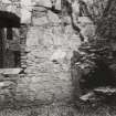
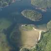
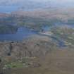
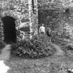
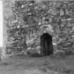
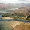
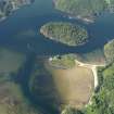
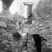
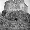
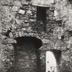
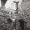
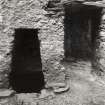
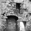
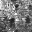
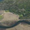
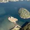
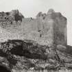
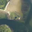
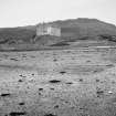
Castle Tioram, 13th century, continuously modified according to fashion until abandonment in the 18th century One of the great Gàidhealtachd strongholds, formerly the administrative centre of Garmoran and the seat of the Clanranalds. Strategically sited on a rocky outcrop in the throat of Loch Moidart, the castle overlooks Eilean Shona and the Shiel estuary in a landscape of superb Picturesque appeal enhanced by 19th century planting. Typical of its genre, it is enclosed by a great curtain wall of probably 13th century date, the round-angled, battered walls of which surround the highest part of the tidal isle. To judge from an odd crenellation, this has been heightened at a later date. The enclosure is entered through a simple, landward-facing gate, topped by a small machicolation reached by a continuous wall-walk (two other postern gates are blocked up). On the east is a small, simple tower, said to have been built in about 1350 by Amy MacRuari, mother of Ranald, the progenitor of the Clanranalds. This was raised in height in the 16th century. Sometime in the early 17th century, the building along the south side, possibly the original feasting hall, was converted into a "main house" of spacious apartments above cellars. This may date from around 1616, when Clanranald, along with other chiefs, entered into an agreement with James VI's government to build "civile and comelie houses for thair duellingis" and "make policie and planting about them". The south range was further remodelled, perhaps c.1668, when Donald, the 13th chief, wrote "I am doing what I can to repaire my old house of Castle Tyrholme" but "I am very scarce of deiles [deals] to it". Its south west section acquired large window openings and a projecting gabled stair tower on the courtyard elevation, and an extra storey embellished with corbelled bartizans and castellations for display; it used the old wall-walk as a promenade overlooking the sea. In the corner between the old tower house and the later south range was the kitchen. All these buildings would have been harled. Foundations of other structures, probably service buildings, line the curtain wall. Stirring and impossibly romantic, the ruin of Tioram stands as a potent symbol of the power struggles and political differences that have fuelled emotions since the Middle Ages. Today it has become the cause célèbre of a new brand of warfare - that waged between the opposing factions of the conservation lobby. The debate centres round the owner Lex Brown's thwarted application to restore and reinhabit the castle; widely supported plans by A.R.P. Lorimer & Assocs were rejected in 2002, after a notorious public enquiry.
Taken from "Western Seaboard: An Illustrated Architectural Guide", by Mary Miers, 2008. Published by the Rutland Press http://www.rias.org.uk

(NM 6621 7243) Castle Tioram (NR) (In ruins).
OS 6" map, Argyllshire, 2nd ed., (1901)
The castle on Eilean Tioram is first mentioned in a charter of 1372. It was garrisoned by the government in the E 18th century and burned down in 1715. It consists of a massive pentagonal curtain wall occupying the whole summit of the rock, within which is a range of stone buildings of which the earliest is the keep, 16th century; the South range was added about 1600 followed by later additions and modifications (Simpson 1954).
Before 1928 the remains of a 5th century bronze hanging-bowl were recovered from a kitchen-midden at Tioram. It is 6 1/2" in diameter and spun from a single piece of bronze. Now in the West Highland Museum (Kilbride-Jones 1937).
M E M Donaldson 1923; H E Kilbride-Jones 1937; W D Simpson 1954.
Castle Tioram, as described and planned by Simpson. About 8.0m NW of the gable of the castle is a cleft in the rock which has almost certainly been used as a midden for the castle, otherwise no further information regarding the find spot of the hanging bowl which is still in the West Highland Museum.
Visited by OS (R L) 3 June 1970.
The hanging-bowl dates within the 5th to 8th centuries but is late, perhaps 7th century.
Information from R B K Stevenson, Keeper, National Museum of Antiquities of Scotland (NMAS).
The castle is 13th century and later.
J G Dunbar 1966.
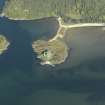
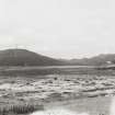
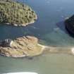
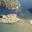
NM 662 724 An underwater survey off the N coast of Eilean Tioram in Loch Moidart was carried out in June 1998. This was based upon the previous discovery of artefacts and archaeological sediments during a preliminary survey carried out in November 1997. Using a shore-based total station the underwater features, artefacts, survey grid and associated shoreline were accurately recorded relative to the island topography and castle structure.
Areas that produced finds and features during the initial 1997 survey were re-evaluated after the seven month absence from this site. Divers employed a systematic swimming survey method using pin flags to mark areas of archaeological interest. Numerous artefacts and features were identified, providing enough data to select a location for the establishment of a 5 x 5m grid to be intensively surveyed and drawn.
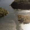
Extending offshore to the N of the castle ruin is a deposit of gravel and sediments darker than the surrounding sea floor. This area contained a fairly high concentration of grey and green slate fragments, pieces of cut stone blocks, and pot sherds. The grid was established within this area.
In the area to the ENE of the tidal island, fragments of an old jetty were found, including a substantial surviving structure and a scatter composed of loose planking and some thin metal rails on the sea floor. The visible extent of this feature, above and under water, was surveyed and the locations of the jetty fragments and the general dimensions of the scatter were recorded.
A concentration of possible cut stone blocks was identified at c 10msw (metres sea water), off the craggy shore of the NE quadrant of Eilean Tioram. There are no surviving structures on land in this area to relate the blocks to, although a level area which could support a small structure is located nearby.
A scatter of bottles was found in the centre of the channel between Eilean Tioram and island of Riska. This scatter contained champagne, whisky, and wine bottles; most likely from the latter part of this century.
Numerous fragments of slate, both grey and green, and some pot sherds were located to the WNW of the island. The bottom here is primarily composed of sand, which is constantly shifting due to tidal action, thus exposing and covering artefacts on a continual basis.
The submerged archaeological landscape around Castle Tioram is quite varied and provides information on numerous aspects of the castle's history and its construction. This survey has provided enough data to identify areas where an excavation or more intensive survey programmes could provide valuable information relating to the past activities at Castle Tioram.
Sponsor: Society of Antiquaries of Scotland.
D A McCullough and M Taylor 1998
NM 661 724 A fieldwork programme, including an integrated survey of the island's topography, archaeology and standing buildings, was undertaken during November and December 1997.
Sponsor: ARP Lorimer for Anta Estates.
C Evans 1998
Glasgow University Archaeological Research Division carried out an archaeological monitoring of emergency stabilisation works to the North West curtain wall of Castle Tioram in 2000. The report concluded that the collapsed wall section had been repaired at some point in the Middle Ages to a lower standard. The inner core of the wall, however, was of original build.
NMRS MS/725/286.
Situated in Moydart, or Moidart, a district on the mainland in the S.W. extremity of Inverness-shire, and on the margin of the indent or bay of the sea called Loch Moidart. Groome's Gazetteer of Scotland, 1901, refers to the 'ruined castle' there.
In a report dated at Edinburgh October 3rd, 1748, made by David Watson, Engineer, on the state of the Castles of Tyrrim, Duart, and Island Stalker (Shuna), and contained among a series of Drawings of the board of Ordnance (Reference MSS. 1645-1652) held in Volume or Case No. 1648 by the National Library of Scotland, he refers to Castle Tyrrim, as at that time, thus: "Castle Tyrrim is an old ruinous Building belonging to the Clanronald family, it stands on a Rocky Peninsula, that joins Moydart by a narrow neck of Sand.
In the Rebellion 1715, a detachment of the King's Troops was sent to Castle Tyrrim, which detachment was surprised and made prisoners by the Rebells who burnt the Castle.
If this Castle was repaired it might accommodate a party of 50 men, the repairs would cost at least 800 [pounds]; the Walls of the Building being quite insufficient, from the burning and Tryings of the Weather".
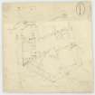
In the National Library of Scotland is a series of Military Maps and Drawings (many are coloured) of the Board of Ordnance, relating to the works executed in the 18th Century (Reference MSS. 1645-1652), and in Volume or Case 1648 is contained the report quoted above so far as relating to Castle Tyrrim, and the following Drawings:
No.Z.3/25.-Plann of Castle Tyrholme in Moidart, to scale one Inch to every 10 Feet; with Profile, or view. Indicated as Surveyed and deliver'd by Lewis Petit. There is no date, but there is a copy dated 1741.
Z.3/28.-Plan, to scale of 40 Feet to an Inch, and a View of Castle Tyrim in Muydart; and, on the same sheet, Plan to scale of 60 Feet to an Inch, and 2 Veiws of Castle Duirt in the Island of Mull. The Plan is dated 1748. Thre is also a copy. (This Drawing is also entered under Castle Duart).
In the Index Volume of the series quoted, numbered 1652, it is stated that Castle Tioram (Tyrim in Moidart or Muydart) is a scheduled monument: it was put into a state of repair at the instance of the owner, Mr Wiseman Madconald of Los Angeles, U.S.A., by the A.M. Department, H.M.O.W.
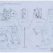
Macgibbon and Ross, in "The Castellated and Domestic Architecture of Architecture of Scotland", give the name as the Castle of Ellan-Tirrim. They give an Historical Note, with a Plan and a pen and ink sketch.
Non-Guardianship Sites Plan Collection, DC23166- DC23168, 1926.
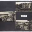
Photographic Survey (September 1963)
Photographic survey by the Scottish National Buildings Record in September 1963.

