
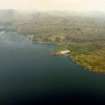
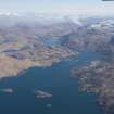
Eilean Nan Gobhar, Sound Of Arisaig


Fort (Period Unassigned)
Site Name Eilean Nan Gobhar, Sound Of Arisaig
Classification Fort (Period Unassigned)
Alternative Name(s) Eilean Nan Gobhar 2
Canmore ID 22510
Site Number NM67NE 2
NGR NM 6937 7946
Datum OSGB36 - NGR
Permalink http://canmore.org.uk/site/22510


- Council Highland
- Parish Arisaig And Moidart
- Former Region Highland
- Former District Lochaber
- Former County Inverness-shire
Field Visit (1 June 1970)
NM67NE 2 6937 7946.
See also NM67NE 1.
(NM 6937 7946) Vitrified Fort (NR) (Remains of)
OS 6" map, Argyllshire, 2nd ed., (1902)
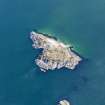
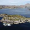
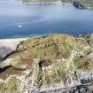
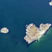
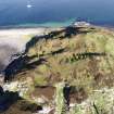
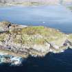
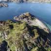
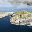
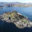
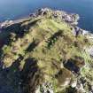
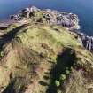
There are two vitirfied forts on Eilean nan Gobhar, a rocky cliff-girt islet.
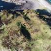
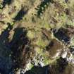
The smaller (see NM67NE 1 for the other) on a separate lower, rise, is oval on plan, measuring c. 25.0m E to W by c 16.0m transversely, within a heavily vitrified wall c. 4.5m to 5.0m thick. The outer face is visible up to 3 courses high around most of the S arc and for a short distance in the N but no inner face can be seen. No entrance is apparent. The W part of the interior is contained by a curving bank of rubble stones which may be the remains of a hut wall.
Visited by OS (N K B) 1 June 1970.
Sources: E Hamillton 1880; R W Feachem 1963.
Note (21 November 2014 - 18 May 2016)
Set on a rocky terrace at the N end of this small cliff-girt island, no more than 40m N of the vitrified fortification on the summit, is a second small fortification, which also displays evidence of extensive vitrifaction. Oval on plan, it measures about 25m from ESE to WNW by 16m transversely (0.04ha) within a wall spread up to 5m in thickness; no trace of the inner face can be seen, but there is a long run of outer face standing three courses high around the S side and its line can also be followed over a short distance on the N. The position of the entrance is not known but there is possible evidence of a stone structure in the W end of the interior.
Information from An Atlas of Hillforts of Great Britain and Ireland – 18 May 2016. Atlas of Hillforts SC2536

