
Following the launch of trove.scot in February 2025 we are now planning the retiral of some of our webservices. Canmore will be switched off on 24th June 2025. Information about the closure can be found on the HES website: Retiral of HES web services | Historic Environment Scotland
Beaquoy


Burnt Mound (Prehistoric)
Site Name Beaquoy
Classification Burnt Mound (Prehistoric)
Canmore ID 2251
Site Number HY32SW 11
NGR HY 3010 2198
Datum OSGB36 - NGR
Permalink http://canmore.org.uk/site/2251


- Council Orkney Islands
- Parish Birsay And Harray
- Former Region Orkney Islands Area
- Former District Orkney
- Former County Orkney
HY32SW 11 3010 2198
(HY 3010 2198) Tumulus (NR)
OS 6" map, Orkney, 2nd ed.,(1900)
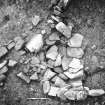
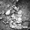
A mound of burn stones.
RCAHMS 1946
Only a slight rise with a scatter of burnt stones on it remains. Most of the mound was removed 'more than twenty years ago' by a previous farmer. (Information from Mr R Scott, Beaquoy, Dounby).
Site confirmed as published (J W Hedges 1974).
Visited by OS (RL) 29 May 1967
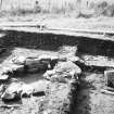
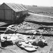
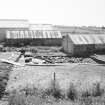
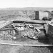
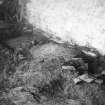
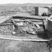
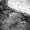
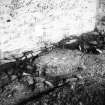
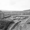
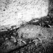
Beaquoy burnt mound was situated on a triangular piece of waste ground between a stream that had previously been dammed, a farm track and a ploughed field. The main part of the mound was levelled in the 19th century and two sheds put in its place (one still stands). The margins of the mound were affected therefore its size is uncertain.
On investigation it proved to be two mounds formed from two buildings which were probably occupied sequentially. One building rested on the old ground surface and was probably primary. Some of the refuse from this was thrown to the E where the second house was later built.
The mound sealed a natural stream bed in which were found the majority of flint artefacts and bones. The composition of the mound was identical to the mound at Liddle which was excavated at the same time.
J W Hedges (North of Scotland Archaelogical Society), Proc Soc Antiq Scot, 1974-5.
Field Visit (29 May 1967)
Only a slight rise with a scatter of burnt stones on it remains. Most of the mound was removed 'more than twenty years ago' by a previous farmer. (Information from Mr R Scott, Beaquoy, Dounby).
Site confirmed as published (J W Hedges 1974).
Visited by OS (RL) 29 May 1967
Excavation (1974)
Beaquoy burnt mound was situated on a triangular piece of waste ground between a stream that had previously been dammed, a farm track and a ploughed field. The main part of the mound was levelled in the 19th century and two sheds put in its place (one still stands). The margins of the mound were affected therefore its size is uncertain.
On investigation it proved to be two mounds formed from two buildings which were probably occupied sequentially. One building rested on the old ground surface and was probably primary. Some of the refuse from this was thrown to the E where the second house was later built.
The mound sealed a natural stream bed in which were found the majority of flint artefacts and bones. The composition of the mound was identical to the mound at Liddle which was excavated at the same time.
J W Hedges (North of Scotland Archaelogical Society), Proc Soc Antiq Scot, 1974-5.
Orkney Smr Note
Tumulus, Beaquoy Farm, On the bank of a small stream
immediately behind the farm outbuildings at the farm of Beaquoy
and only a few paces from the roadway there has been a fairly
large mound composed mainly of small angular burnt stones. The
construction has in parts been removed and a poultry run has been
erected on part of the SW segment. No very regular outline can be
determined but originally the mound probably had a diameter of at
least 45ft and was 4ft 6in high. [R1]
Beaquoy. Behind the farm outbuildings at Beaquoy.
[R2]
Information from Orkney SMR [n.d.]

