
Loch Of Huxter


Broch (Iron Age)
Site Name Loch Of Huxter
Classification Broch (Iron Age)
Canmore ID 224
Site Number HU15NE 4
NGR HU 1727 5694
Datum OSGB36 - NGR
Permalink http://canmore.org.uk/site/224


- Council Shetland Islands
- Parish Walls And Sandness
- Former Region Shetland Islands Area
- Former District Shetland
- Former County Shetland
HU15NE 4 1727 5694.
(HU 1728 5695) Brough (NR)
OS 6" map, Shetland, 2nd ed., (1903)
A broch now in a ruinous condition.The inner face of the wall can be traced all the way round varying from a mere foundation to 6 feet in height. In the south arc is the entrance to the remains of a mural cell. The interior diameter is 31 feet 9 inches and a small segment of outer wall visible on the NNW shows the wall-thickness to be 14 feet.
Sources: RCAHMS 1946, visited 1931; J Spence 1899
The remains of this broch are as described by RCAHMS. The interior has been adapted to form a sheep-fold.
Surveyed at 1/2500.
Visited by OS (WDJ) 15 June 1968
Publication Account (2002)
HU15 1 LOCH OF HUXTER 1 (‘Broch of Easter’)
HU/173570 (visited 4/6/63)
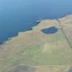
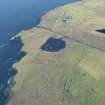
Probable ground-galleried broch in Walls and Sandness, on flat ground next to a small loch (Ills. 4.4 and 4.5). In defensive terms the site stands in a weak position, on flat ground in the midst of farmland and next to the Loch of Huxter, at the north end of its east shore (Ills. 4.4 and 4.5). There is a massive rampart surrounding the broch on its landward approaches, not mentioned in the Commission's account (Ill. 4.4). Spence refers to “… a gigantic building, double walled, chambered like a beehive, and fitted up with every convenience.” [3]. Apparently much stone was removed from it in about 1840 to build dikes [3] and the broch is now in a very ruinous condition. However several interesting features can be made out.
Part of the interior wall face is visible (though a sheep pen has been built inside the structure) and it stands to 5 - 6 ft. on the north and north-east. The part containing the main entrance has, however, been completely wrecked. A doorway in the interior wall face leads to a length of intact mural gallery -- lintelled over -- which runs to the left and emerges from the broken end of the wall (Ill. 4.5). Here it can clearly be seen to be expanding into an oval mural cell. This particular arrangement -- whereby a length of gallery runs only one way from a door and expands into a cell at its end -- is found at only one other site (HU25 7 below).
Dimensions: the internal diameter is 31 ft. 9 ins. and the wall, at the one measurable point, is 14 ft. thick: thus the walls proportion is about 46.7%.
Finds: during the ransacking of this broch querns, "mallets", knives, pottery and animal bones were found but were thrown away [2: 3, 52-3].
Sources: 1. OS card HU 15 NE 4 (with sketch plan): 2. RCAHMS 1946, vol. 3, no. 1605, 146 (no plan): 3. Spence 1899, 52.
NMR photographs: 5P.
E W MacKie 2002

