 |
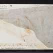
On-line Digital Images |
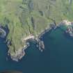
DP 076976 |
RCAHMS Aerial Photography Digital |
Oblique aerial view of Ockle point with Swordle Farm in the distance, taken from the NNW. |
1/6/2009 |
Item Level |
|
 |
On-line Digital Images |
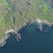
DP 076977 |
RCAHMS Aerial Photography Digital |
Oblique aerial view of Ockle point with Swordle Farm in the distance, taken from the NW. |
1/6/2009 |
Item Level |
|
 |
On-line Digital Images |
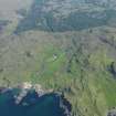
DP 076978 |
RCAHMS Aerial Photography Digital |
Oblique aerial view of Swordle Farm, taken from the NNW. |
1/6/2009 |
Item Level |
|
 |
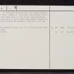
On-line Digital Images |
SC 2382959 |
Records of the Ordnance Survey, Southampton, Hampshire, England |
Ardnamurchan, Cladh Aindreis, NM57SW 2, Ordnance Survey index card, page number 1, Recto |
1958 |
Item Level |
|
 |
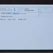
On-line Digital Images |
SC 2382960 |
Records of the Ordnance Survey, Southampton, Hampshire, England |
Ardnamurchan, Cladh Aindreis, NM57SW 2, Ordnance Survey index card, page number 2, Verso |
1958 |
Item Level |
|
 |
On-line Digital Images |
SC 2382961 |
Records of the Ordnance Survey, Southampton, Hampshire, England |
Ardnamurchan, Cladh Aindreis, NM57SW 2, Ordnance Survey index card, Recto |
1958 |
Item Level |
|
 |
On-line Digital Images |
SC 2382962 |
Records of the Ordnance Survey, Southampton, Hampshire, England |
Ardnamurchan, Cladh Aindreis, NM57SW 2, Ordnance Survey index card, Recto |
1958 |
Item Level |
|


