
Eigg, Galmisdale


Dun (Prehistoric)
Site Name Eigg, Galmisdale
Classification Dun (Prehistoric)
Canmore ID 22171
Site Number NM48SE 1
NGR NM 48456 83809
Datum OSGB36 - NGR
Permalink http://canmore.org.uk/site/22171


- Council Highland
- Parish Small Isles
- Former Region Highland
- Former District Lochaber
- Former County Inverness-shire
NM48SE 1 48456 83809
(Area NM 485 837) What has clearly been a large fort (or dun) is indicated by the discovery of the remains of a massive circular wall (diameter 90ft) on a small promontory which encloses MacBraynes pier buildings, Eigg. The public road bisects the structure.
Reported by D MacKinnon, Cleadale.
I A Crawford 1964
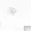
At NM 4844 8380, the remains of a dun, bisected by a road and with its interior partly occupied by a modern building. Sub-circular on plan it measures overall 26.4m NW-SE by 26.1m transversely with the base course of the outer wall face visible intermittently for much of the periphery. Traces of the inner face are visible in the SW, and one or two possible inner facing stones are evident in the N giving a wall thickness varying between 2.7m and 2.3m. Natural outcrops have been incorporated in the wall. The entrance is not evident.
Surveyed at 1/10 000; enlargement at 1/1250.
Visited by OS (AA) 8 May 1972
Measured Survey (6 September 2001)
RCAHMS surveyed the dun at Galmisdale on 6 September 2001 with plane-table and self-reducing alidade at a scale of 1:500.
Field Visit (10 October 2002)
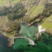
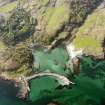
This extensively robbed dun stands on Galmisdale Point, immediately above the pier (NM48SE 51). Kidney-shaped on plan, it has measured overall about 28m from NNW to SSE by about 25m transversely. The wall is best preserved on the S and SW, where stretches of inner and outer face can be seen, though nowhere standing more than one course high; the wall here measures up to 2.8m in thickness. On the N, occasional grounders allow the line of the outer face to be traced, but on the E it has either been destroyed or masked by later disturbance. The road from the pier runs from the E to W through the centre of the dun; on the S side of the road most of the interior is occupied by a former tearoom, a crenellated building constructed for Walter Runciman in the 1920s (NM48SE 50), while to the N of the road the whole interior has been levelled and is in use as a car park.
(EIGG01 512)
Visited by RCAHMS (SDB) 10 October 2002

