
Following the launch of trove.scot in February 2025 we are now planning the retiral of some of our webservices. Canmore will be switched off on 24th June 2025. Information about the closure can be found on the HES website: Retiral of HES web services | Historic Environment Scotland
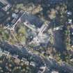
Stirling, 1-13 St Ninian's Road, Viewforth House


Local Government Office (20th Century), Post Hole(S) (Prehistoric), Villa (19th Century), Unidentified Pottery(S) (Medieval)
Site Name Stirling, 1-13 St Ninian's Road, Viewforth House
Classification Local Government Office (20th Century), Post Hole(S) (Prehistoric), Villa (19th Century), Unidentified Pottery(S) (Medieval)
Alternative Name(s) Central Region Headquarters
Canmore ID 221324
Site Number NS79SE 483
NGR NS 79649 92873
Datum OSGB36 - NGR
Permalink http://canmore.org.uk/site/221324


- Council Stirling
- Parish Stirling
- Former Region Central
- Former District Stirling
- Former County Stirlingshire
See also NS79SE 704
Watching Brief (10 June 2013 - 14 June 2013)
AOC Archaeology undertook an archaeological evaluation in respect to a proposed development within the grounds of Stirling Council at Viewforth, St. Ninians Road, Stirling (NGR; NS 7953 9282). The area (3600 m2) was subject to an 8% sample evaluation to comprise 72 linear metres. However the presence of live services and heavy tree canopy reduced the current works to 62 linear metres. The evaluation revealed thirteen pits/post-holes of probable prehistoric date. These features formed a right angled linear alignment and are the possible remains of a substantial post-built structure or enclosure.
Three sherds of late medieval reduced ware pottery were recovered from the interface of the top-soil and natural. These included two body sherds and a skillet handle.
AOC Archaeology Group (R. Engl) OASIS ID: aocarcha1-152783

