
Rum, Harris


Cairn (Prehistoric)(Possible), Cairn (Modern), Mound (Prehistoric)(Possible)
Site Name Rum, Harris
Classification Cairn (Prehistoric)(Possible), Cairn (Modern), Mound (Prehistoric)(Possible)
Alternative Name(s) Rhum
Canmore ID 21911
Site Number NM39NW 3
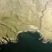
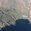
NGR NM 34200 95519
Datum OSGB36 - NGR
Permalink http://canmore.org.uk/site/21911


- Council Highland
- Parish Small Isles
- Former Region Highland
- Former District Lochaber
- Former County Inverness-shire
NM39NW 3 3419 9552.
(NM 342 955) An oval cairn 32' x 30' and about 3' high in the centre, built of waterworn pebbles appreciably larger than the stones of the raised beach on which the cairn is built. On the seaward side the cairn is partly covered with turf; on the landward side, in the SE quadrant, two large depressions in the cairn material suggest deliberate disturbance. A much smaller cairn, presumably modern, of unweathered boulders, has been built on top.
Source: G C David 1967
A cairn at NM 3419 9552 measuring 12.0m in diameter and 1.0m high, howked in two places in the S arc, generally as described by David. About 70 metres N at NM 3419 9560 is a mound of similar construction 6.5m in diameter and 0.4m high. Another mound of the same size, overgrown with peat, and with its centre howked lies about 60 metres NW at NM 3413 9562. A rubble wall extends SW from its SW side. Neither of these two mounds can be positively identified as cairns.
Visited by OS (AA) 14 May 1972
Field Visit (May 1983)
Harris NM 34 95 NM39NW 3&4
Situated on the raised storm-beach SW of Harris there are five stony mounds.
(1) NM 3419 9553. This cairn sits on the forward edge of the raised beach; it measures 11.5m in diameter by 0.9m in height and is surmounted by a modern cairn.
(2) NM 3419 9559. About 60m NNW of (1) there is a mound of stones 7.1m in diameter and 0.6m high.
(3) NM 3412 9562. About 110m NW of (1) there is a stony mound 6.5m in diameter by 0.5m high which is surrounded by a ditch-like hollow. The mound sits on the line of a field-bank which runs for a short distance to the NE and SW.
(4) NM 3407 9568. About 40m WNW of a recent fank there is a stony mound 3.5m in diameter and 0.4m high; it is surrounded by a slight hollow which appears to cut through the crest of the adjacent rig.
(5) NM 3403 9569. Some 35m WNW of (4) there is a stony mound 6m in diameter by 0.3m high; it is surrounded by a slight hollow. The date and purpose of these mounds are uncertain; some may be prehistoric burialcairns while others may be clearance heaps.
RCAHMS 1983, visited May 1983
(DES, 1967, 28)
Field Visit (13 October 2010)
This cairn is generally as described in 1983. The mounds to the NNW (at NM 34185 95603) and NW (at NM 34133 95622) are both at least partly-overgrown with peat and heather.
Visited by RCAHMS (SDB, ARG) 13 October 2010.

