 |
On-line Digital Images |
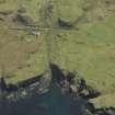
DP 027220 |
RCAHMS Aerial Photography Digital |
Oblique aerial view centred on the remains of the township, taken from the NNW. |
26/4/2007 |
Item Level |
|
 |
On-line Digital Images |
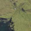
DP 027221 |
RCAHMS Aerial Photography Digital |
Oblique aerial view centred on the remains of the township, taken from the NW. |
26/4/2007 |
Item Level |
|
 |
On-line Digital Images |
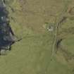
DP 027222 |
RCAHMS Aerial Photography Digital |
Oblique aerial view centred on the remains of the township, taken from the WSW. |
26/4/2007 |
Item Level |
|
 |
On-line Digital Images |
SC 2381881 |
Records of the Ordnance Survey, Southampton, Hampshire, England |
Mull, Lag, NM35SE 30, Ordnance Survey index card, Recto |
c. 1958 |
Item Level |
|
|
All Other |
551 166/1/1 |
Records of the Ordnance Survey, Southampton, Hampshire, England |
Archaeological site card index ('495' cards) |
1947 |
Sub-Group Level |
|


