
Ulva, Glacgallon


Head Dyke (Post Medieval), Township (Period Unassigned)
Site Name Ulva, Glacgallon
Classification Head Dyke (Post Medieval), Township (Period Unassigned)
Canmore ID 21818
Site Number NM34SE 6
NGR NM 381 410
NGR Description Centred NM 381 410
Datum OSGB36 - NGR
Permalink http://canmore.org.uk/site/21818


- Council Argyll And Bute
- Parish Kilninian And Kilmore
- Former Region Strathclyde
- Former District Argyll And Bute
- Former County Argyll
NM34SE 6 centred 381 410
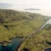
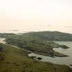
Three small settlements consisting in total of fifteen buildings and three corn drying kilns. Most of the buildings have rounded corners and measure 30' x 15'.
G Gandy 1962
Several farmsteads depopulated c. 1851 called Glacgallon, generally as described by Gandy.
Visited by OS 15 May 1972
A crofting township comprising twenty-four unroofed buildings, six enclosures and a head-dyke is depicted on the 1st edition of the OS 6-inch map (Argyllshire, Island of Mull 1881, sheet lxxxi). Twenty unroofed buildings, five enclosures and a head-dyke are shown on the current edition of the OS 1:10000 map (1975).
Information from RCAHMS (SAH) 29 June 1998
Sites recorded during survey for the Scottish Agricultural College, under the Historic Scotland Ancient Monument Survey Grant Scheme.
NM 384 412 Deserted settlement.
NM 379 407 Deserted settlement.
Sponsors: Historic Scotland, Scottish Agricultural College.
T Rees 1998.
Field Visit (10 May 2012 - 12 June 2012)
NM 3972 4100 (centred on) A walkover survey was undertaken 10 May – 12 June 2012 in advance of a woodland establishment scheme. The survey identified new sites of archaeological interest including farmsteads and ancillary buildings, shielings, enclosures, boundary walls and areas of rig and furrow cultivation. Settlement remains within planned open areas within the planting scheme were also recorded to complete the record of settlement within the Phase 3 survey area.
The survey completed three phases of archaeological survey on the island of Ulva in advance of this major tree planting scheme The survey recorded a complex and quite densely settled area, containing a wide range of features and extensive field dykes/land divisions and areas of relict rig and furrow cultivation. The survey provides a record of a well preserved post-medieval landscape including all elements of the settlement system and evidence for a transhumance economy using shielings and their associated enclosures and stock pens.
Archive: HHER, RCAHMS and WCAS (intended)
Funder: Ulva Estate and Miller Harris
Information from Steven Birch, West Coast Archaeological Services (12th of June 2012).
OASIS ID - westcoas1-128038

