
Ulva, Dun Ban


Island Dwelling (Medieval)
Site Name Ulva, Dun Ban
Classification Island Dwelling (Medieval)
Canmore ID 21812
Site Number NM34SE 1
NGR NM 3841 4160
Datum OSGB36 - NGR
Permalink http://canmore.org.uk/site/21812


- Council Argyll And Bute
- Parish Kilninian And Kilmore
- Former Region Strathclyde
- Former District Argyll And Bute
- Former County Argyll
NM34SE 1 3841 4160.
(NM 3841 4160) Dun Ban (NR)
OS 1:10,000 map, (1976)
The remains on Dun Ban are as described by RCAHMS. The name 'Glackingdaline Castle' could not be confirmed.
Surveyed at 1:10,000.
Visited by OS (RD) 19 May 1972.
Site recorded during survey for the Scottish Agricultural College, under the Historic Scotland Ancient Monument Survey Grant Scheme.
NM 3841 4160 Island dwelling (NM34SE 1).
Sponsors: Historic Scotland, Scottish Agricultural College.
T Rees 1998
Field Visit (June 1973)
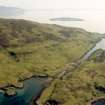
Dun Ban, Ulva (NM 384 416)
This rocky tidal islet is situated in the N portion of Am Bru, the narrow channel separating Ulva from Gometra. The level summit-area is surrounded by sheer cliffs some 10m in height, interrupted only by a narrrow gully, the sole means of approach, on the S, and by an area of sloping ground on the W flank. Access from the foreshore to the latter area was denied by a dry-stone wall, 1.1m thick and standing in places to a height of 1.9m, which fills the gap in the circuit of cliffs.
On the summit of the rock there are the remains of a substantial building of dry-stone masonry measuring 11.3m from N to S by 5.8m transversely over walls 1.1m thick which stand to an average height of 0.9m. The angles are noticeably rounded, both internally and externally, and two opposed doorways situated towards the S ends of the side-walls.
Access to the island from Ulva was facilitated by a causeway 2.7m in width and about 60m in length, to the S of which, on the Ulva shore, rocks have been removed to form a boat-inlet. A small bay immediately to the SW also contains an inlet and two boat-noosts; these were probably associated with the former township of Baligortan, situated a short distance to the NE.
The remains on Dun Ban may be ascribed to the late medieval period, and it was presumably a residence of members of the family of MacQuarrie of Ulva. There are no records of the cadet branches of this family before the mid-17th century, and no references to the site have been identified before the 19th century, when it was described as 'Glackingdaline Castle' (NSA 1845, 349).
RCAHMS 1980, visited June 1973.

