
Following the launch of trove.scot in February 2025 we are now planning the retiral of some of our webservices. Canmore will be switched off on 24th June 2025. Information about the closure can be found on the HES website: Retiral of HES web services | Historic Environment Scotland
Dun Aisgain, Mull


Broch (Iron Age), Dun (Period Unassigned)
Site Name Dun Aisgain, Mull
Classification Broch (Iron Age), Dun (Period Unassigned)
Alternative Name(s) Dun Aisgain Broch, Isle Of Mull
Canmore ID 21807
Site Number NM34NE 8
NGR NM 3774 4524
Datum OSGB36 - NGR
Permalink http://canmore.org.uk/site/21807


- Council Argyll And Bute
- Parish Kilninian And Kilmore
- Former Region Strathclyde
- Former District Argyll And Bute
- Former County Argyll
NM34NE 8 3774 4524.
(NM 3774 4524) Dun Aisgain (NR)
OS 1:10,000 map, (1976)
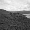
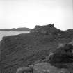
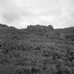
Dun, Dun Aisgain: This remarkably fine example of a galleried dun occupies a conspicuous position on the summit of a low rocky knoll some 600m SSW of Burg farm-house. It is almost exactly circular on plan, measuring 10.4m in diameter within a stone wall which measures 2.3m in average thickness but increases to 2.75m on each side of the entrance. The wall is in an exceptionally good state of preservation, particularly on the NW, where the outer face survives to a height of 2.75m in twelve courses, the lower portion rising vertically for 1.5m and the upper exhibiting an inward batter of 0.3m; in the same sector the inner face stands 1.75m high in eight courses. Nearly all the circuit of both the inner and outer face can still be traced, and there is no indication that the former either incorporated a scarcement or was interrupted to provide access to the internal gallery, 0.3m wide, that can be seen in the thickness of the wall at several points. The entrance, in the W and partly choked with debris, is 1.1m wide internally and only 0.8m wide at the outer end. However, about half-way along the passage, where it has been checked for a wooden door, the width increases to 1.35m; there are traces of a square bar-hole, 0.15m wide, just inside the rebate in the S passage-wall. Three lintels are still in position over the entrance- passage, while a fourth has been dislodged and lies on top of the debris immediately outside.
An outwork in the form of a stone wall has been drawn round the irrgular margin of the summit outside the dun. It appears, for the most part, as a low grass-covered band of stony debris, but on the SW it is better preserved and the outer face stands to a height of 1.9m in six courses; no inner facing-stones can, however, be seen. The entrance probably lay on the W, opposite the entrance to the dun. A sub-rectangular enclosure of no great age has encroached upon the inner line of the outer wall on the WSW, and a recent dyke overlies the outwork on the W.
Surveyed at 1:10,000.
RCAHMS 1980, visited 1974; Visited by OS (DWR) 25 April 1972.
Field Visit (7 June 1934)
Dun Aisgain, Port Burg.
Crowns summit of rock on a platform 200 with cliffs above and below but once cultivated. Wall at entrance 9' thick internal diameter 34 x 32. Entrance 2' 3/4" external and 4' 1/4" internal, lintels still in situ. Traces of gallery in wall. On E cliff falls away sheer from lower base but on W part of rock top is defended by an outwork the outer face of which extends to 25' from lower wall. Entrance on NNW.
Visited by VG Childe 7 June 1934.
Original field notes held in MS 36 and typed version included with Emergency Survey (WP 003403).
Field Visit (27 July 1942)
This site was recorded as part of the RCAHMS Emergency Survey, undertaken by Angus Graham and Vere Gordon Childe during World War 2. The project archive has been catalogued during 2013-2014 and the material, which includes notebooks, manuscripts, typescripts, plans and photographs, is now available online.
Information from RCAHMS (GF Geddes) 4 December 2014.
Publication Account (2007)
NM34 1 DUN AISGEAN
NM/3774 4524
There is little doubt about the identity of this unexcavated broch in Kilninian and Kilmore even though it is classed as a “galleried dun” in the latest account [3] (visited 5/6/64 and 6/10/89). The structure is well preserved, the wall standing nearly 3.05m (10 ft) high until recently but a little less in 1974 [3]; it stands on a rock knoll with some sheer faces. The site is close to the sea and overlooks it, and is not far from some formerly cultivated land with ruined crofts. Some of the blocks in the wall are very large and the lintels over the entrance are massive. The lower part of the external wallface is vertical, the upper part battered.
1. Description
The entrance faces just west of south and has built rebates for a door about 1.65m (5 ft 6 in) from the exterior; one of the checks was still visible in 1989. Within the door-frame the passage width increases from 1.0m to 1.5m. A very large lintel has fallen forward from the front end but is not triangular; it must however have stood on edge originally, and have supported the weight of the outer wallface. An unusual feature is the weed-covered masonry which runs over the lintel at the inner end of this passage; if this is original there would seem to have been no opening to the interior from any chamber over the entrance. The passage is 2.90m (9 ft 6 in) long indicating a relatively thin wall for a broch.
Immediately clockwise from the entrance a narrow length of mural gallery can be seen by peering into the rubble. Only about 0.30cm (12 in) wide, it stands higher than the entrance lintels and ought therefore to be in Level 2. Its rough sides are traceable to about 9 o’clock where there are signs of a doorway to the interior, presumably raised. At the right edge of this door is another very large lintel bridging the gallery. A scarcement of the ledge type – turfed over in places, uneven in level and about 38 - 45cm (15 - 18 in) wide – is traceable intermittently from about 6-9 o’clock, to just beyond the possible gallery door. Thereafter the inner face is visible at a slightly lower level. The narrow gallery is again visible at about 10.30 o’clock and its lintels must here be about 90cm (3 ft) above the scarcement.
There has been an outer wall all the way round the broch – following the irregular edge of the summit of the knoll – but it is only visible as such on the south-west, where the outer face stands six courses high.
2. Discussion
In spite of its relatively thin wall Dun Aisgean is classified as a hollow-walled broch here because of, first, its clear Level 2 gallery, second its scarcement and, third, the massive lintel in front of the entrance which seems to indicate a high wall. The Commission investigators do not mention the scarcement or the possible gallery door at 9 o’clock and this doubtless explains the term they used for this site [3]. Nevertheless Dun Aisgean is not typical of a broch, firstly because of the thinness of its wall and secondly because of the masonry resting on the innermost lintel of the entrance, though this could be the result of misguided ‘reconstruct-ion’ in modern times of the kind which one so often sees in remote highland brochs.
3. Dimensions
The external diameter is 15.10m (49.5 ft) from 6 - 12 o’clock and the same from 9 - 3 o’clock; the corresponding internal diameters are 9.30m (30.5 ft) and 9.46m (31 ft). The wall proportion is thus 38.4% and the average wall thickness is 2.86m (at the entrance it is 2.9m, as noted). The Commission [3] gives slightly different measurements – an internal diameter of 10.4m with an average wall thickness of 2.3m increasing to 2.75m at the entrance. The wall proportion would thus be 30.7%, much less than the author’s figure.
Sources: 1. NMRS site no NM 34 NE 8: 2. Duns 1883, 86-7: 3. RCAHMS 1980, 101, no. 186, fig. 107 and pl. 15, B and C: 4. Ritchie and Harman 1996, 128.
E W MacKie 2007

