
Ulva, Cille Mhic Eoghainn


Burial Ground (Period Unassigned)
Site Name Ulva, Cille Mhic Eoghainn
Classification Burial Ground (Period Unassigned)
Canmore ID 21781
Site Number NM33NE 1
NGR NM 3953 3890
Datum OSGB36 - NGR
Permalink http://canmore.org.uk/site/21781


- Council Argyll And Bute
- Parish Kilninian And Kilmore
- Former Region Strathclyde
- Former District Argyll And Bute
- Former County Argyll
NM33NE 1 3953 3890.
(NM 3953 3890) Cille Mhic Eoghainn (NR)
OS 1:10,000 map, 1975
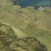
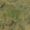
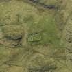
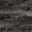
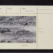
Burial-ground, Cill Mhic Eoghainn, Ulva: This burial-ground is sub-rectangular on plan and measures about 35m from N to S by 22m transversely within a boundary-wall of 19th century date. At the highest point there is a rectangular enclosure of lime-mortared rubble masonry, measuring 9.5m from E to W by 4.4m transversely within walls having a thickness of some 0.5m. The only entrance to this enclosure is an opening in its E wall, which forms part of the perimeter of the burial-ground; it contains a headstone erected in 1791. Although in its present form the entire structure is evidently a private burial enclosure of about that date, its walls appear to stand on more substantial footings, which may incorporate some fragments of the early church referred to, but apparently not visited, by Dr Johnson in 1773. The main burial-ground contains many simple uninscribed grave-markers. The earliest inscribed stone is dated 1765.
The name of this burial-ground first appears on record as 'Kilvc Ewyn' in 1630, when it evidently refers to an associated township. It has been suggested (MacKinlay 1914) that the dedication, like that of the parish church of Kilvickeon was to Ernan son of Eoghan, a nephew of St Columba.
J M MacKinlay 1914; RCAHMS 1980, visited June 1972.
The bell of the pre-Reformation chapel of Kilviceuen was found here some years ago among the ruins.
New Statistical Account (NSA) 1845.
This burial ground contains two rectangular enclosures, both orientated E-W and containing graves. 'A' is as described by the RCAHMS (1980), while 'B' measures 6.4m by 3.5m within a dry-stone wall 0.5m thick and up to 1.0m high. The entrance is in the E. Neither enclosure shows any positive evidence of having been a chapel.
The burial ground (name confirmed) is as described.
Surveyed at 1:10,000.
Visited by OS (DWR) 11 May 1972.
Site recorded during survey for the Scottish Agricultural College, under the Historic Scotland Ancient Monument Survey Grant Scheme.
NM 395 389 Burial ground
Sponsors: Historic Scotland, Scottish Agricultural College.
T Rees 1998

