
Broch Of Burgar


Broch (Iron Age)
Site Name Broch Of Burgar
Classification Broch (Iron Age)
Canmore ID 2178
Site Number HY32NE 27
NGR HY 3521 2771
Datum OSGB36 - NGR
Permalink http://canmore.org.uk/site/2178


- Council Orkney Islands
- Parish Evie And Rendall
- Former Region Orkney Islands Area
- Former District Orkney
- Former County Orkney
HY32NE 27 3521 2771.
(HY 3519 2771) Brough (NR)
OS 6" map, Orkney, 2nd ed., (1900).
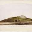
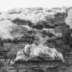
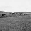
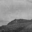
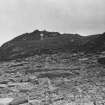
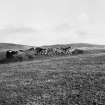
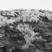
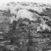
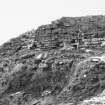
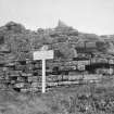
The remains of the Broch of Burgar are buried except for a section of the outer wall-face, on the north side, about 50 ft long and 9 ft high. Slight surface indications of possible cells or galleries can be seen as well. Thomas (F W L Thomas 1852), in 1851, described it as 14 ft high in part, and 60 ft in diameter, with walls about 17 ft thick.
Gordon, some years after 1825, is said to have found two skeletons and a hoard of amber and silver ornaments, in an urn, deposted after the broch fell into ruin, and to have thrown them into the sea to avoid surrendering them to the Crown.(The Orcadian 10 January 1863).
'Two fine gold armillae' from the site are in the possession of the Earl of Zetland. (D Wilson 1851 and G Petrie Ms notebooks Nos.4, 5).
RCAHMS 1946.
The broch of Burgar, as described by the Commission, is in danger of mutilation by cliff erosion. None of the finds could be traced. Resurveyed at 1/2500.
Visited by OS (NKB) 9 June 1967.
Erosion is gradually causing this site to fall into the sea. A polished bone pin and c.30 sherds of coarse broch pottery (undecorated) were found.
B Bell 1980.
The excavations carried out at this site in 1870-1 are mentioned in several additions of 'The Orcadian' and 'The Orkney Herald' newspapers (see references). 'The Orkney and Zetland Chronicle' in 1825 describes the excavation of the broch, and the finds made by the 'clergyman's son's' excavation of the top of the mound. The finds were sent to a Dr Hibbert.
M Howe 2006.
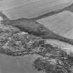
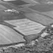
Aerial Photography (1971)
Oblique aerial photographs of Broch of Burgar, Orkney, by John Dewar in 1971.
Publication Account (2002)
HY32 1 BURGAR (‘Broch of Burgar’, ‘Burgher’)
HY/352277
The only information about the size and structure of this probable broch on the coast in Evie and Rendall is from Thomas [2]. He gives the external diameter as 18.3 m (60 ft.) and its internal diameter as 10.4 m (34 ft.): the wall proportion would therefore be about 43.3%. At that time, he says, "upon one side the wall is still fourteen feet high, and is about five feet thick; the inner concentric wall is of the same thickness, and separated from the outer one by a distance of seven feet, the space between being formed into numerous chambers." [8, 60, fig. 3.10] The broch had already been explored. In 1825 one Peterkin dug into the mound and found a few relics, including a human skeleton with a long-handled bone comb beside it [3, fig. 119]), of which he sent the latter to the National Museum. About 15 years later the site was re-open by the proprietor Mr Gordon who is alleged to have found items of gold and silver. Unfortunately the description of these finds [4] is second hand, being derived from two "intelligent gentlemen" who had seen them. Gordon is reputed to have thrown the whole collection into the sea rather than surrender them to the Crown, for whom they had been claimed [6].
Recently further erosion of the broch exposed a polished bone pin and about 30 sherds of undecorated pottery [7].
The “treasure”: the metal and other objects were in a vessel found "in one of the cells in the thickness of the wall" [5], "a highly ornate silver vase or Beaker which would contain about half a gallon of liquid" and which "bulged out about the middle, the mouth and bottom being considerably narrower. Round the middle were projecting knobs and various ornamental figures or designs were stamped or incised upon its surface [4, 89].
The silver articles found with it probably imply a post-Iron Age deposit. The pot "was nearly filled with the following articles, viz. a great number of amber beads, from 3 to 4 inches in diameter down to the size of a pea, including many of the size of half-crowns; several silver combs of various sizes, some 6 inches long, with long teeth, the back or upper part being rounded and perforated with numerous holes; five or six silver pins, some silver buckles or fibulae, and several pieces of silver chains, consisting of three links interwoven, and resembling modern watch chains" [4, 89]. From the position of this hoard Petrie inferred that it had been deposited, together with a human skeleton, after the building had fallen into ruin.
Sources: 1. OS card HY 32 NE 27: 2. Thomas 1852. 122-3: 3. Wilson 1863, 2, 107: 4. Petrie 1890, 85 and 89: 5. Petrie 1927, 23: 6. RCAHMS 1946, 2, 74, no. 261: 7. B. Bell in Disc. and Excav. Scot. 1980, 24: 8. Hedges et al. 1987, 59-60.
E W MacKie 2002
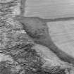
Magnetometry (16 October 2011 - 11 November 2011)
HY 3453 2674 (centred on) An extensive walkover survey covering c175ha was undertaken, 16 October–11 November 2011, in a transect running SW from the Evie coast, as part of PhD research. A total of 28 sites were identified, including 19 previously unrecorded sites. In the main, these sites were related to the post-medieval and early modern exploitation of the landscape. However, a burnt mound was located, as well as possible sub-peat features in an upland area that may be tentatively be assigned a prehistoric date. A targeted gradiometer survey was undertaken on two sites within the survey area.
The first area spanned c4.2ha covering the Knowe of Grugar (HY32NE10) and its surrounding area. The responses were generally well defined, with anomalies suggestive of a substantial roundhouse, with associated domestic activity, surrounded by a large ditch. Outside the ditch the responses and trends in the data demonstrated some enhancement that may relate to the settlement.
The second area of c2.9ha around the partially excavated Broch of Burgar (HY32NE27) also produced well defined responses, with a clear ditch-like anomaly surrounding the roundhouse and associated settlement. Further ditch-like anomalies running c150m inland appeared to indicate a contemporary enclosure of an unusual and substantial nature.
Report: Orkney SMR and RCAHMS (intended)
Funder: Orkney College UHI
Orkney College UHI, 2011

