
Pricing Change
New pricing for orders of material from this site will come into place shortly. Charges for supply of digital images, digitisation on demand, prints and licensing will be altered.
Upcoming Maintenance
Please be advised that this website will undergo scheduled maintenance on the following dates:
Thursday, 9 January: 11:00 AM - 3:00 PM
Thursday, 23 January: 11:00 AM - 3:00 PM
Thursday, 30 January: 11:00 AM - 3:00 PM
During these times, some functionality such as image purchasing may be temporarily unavailable. We apologise for any inconvenience this may cause.
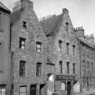
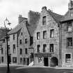
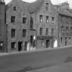
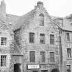
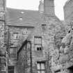
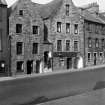
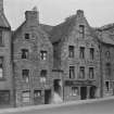
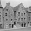
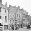
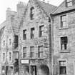
Linlithgow, 46-48 High Street


Shop (17th Century), Tenement (17th Century)
Site Name Linlithgow, 46-48 High Street
Classification Shop (17th Century), Tenement (17th Century)
Alternative Name(s) Hamiltons' Land
Canmore ID 214466
Site Number NT07NW 77.01
NGR NT 00389 77143
Datum OSGB36 - NGR
Permalink http://canmore.org.uk/site/214466


- Council West Lothian
- Parish Linlithgow
- Former Region Lothian
- Former District West Lothian
- Former County West Lothian
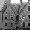
Hamilton's Land, 40-48 High Street, early 16th century
Town houses of the Hamiltons of Pardovan and Humbie restored, 1958, by the National Trust for Scotland as part of the Little Houses Scheme. Twin crowstepped gables to the street linked by a covered stairway rising between to the principal floor. Stone and pantile roofs. Projecting window margins of No 42-44 reveal it once was harled. The gable of the other has a doocot. No 46-48 retains a bread oven in the yard behind.
Taken from "West Lothian: An Illustrated Architectural Guide", by Stuart Eydmann, Richard Jaques and Charles McKean, 2008. Published by the Rutland Press http://www.rias.org.uk

Publication Account (2000)
The Hamilton Lands figure 11 at 40-48 High Street, built for the Hamiltons of Pardovan, give clues to domestic buildings typical of Linlithgow's sixteenth-century main thoroughfare (seep 20), with crowstepped gables and, at Nos 44-48, a flight hole for pigeons. 40-42 is stone-slated and has a round arched pend leading to its back.lands, which are now developed. The two houses are joined by a stair with its own pantiled roof 44-48 is pantiled, with a narrower pend leading to a sixteenth-century stone oven at the rear of the property. Although this has probably been much renovated, it is a reminder of the importance of avoiding fire risk when so much housing was totally or partially of wood. Also, a strong visual comment on the importance of back.lands is the circular beehive-shaped doocot, with its 370 nest holes, which housed an alternative food supply for the family of Ross of Halkhead.
Information from ‘Historic Linlithgow: The Archaeological Implications of Development’ (2000).
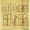
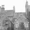
Field Visit (3 October 2011 - 1 November 2011)
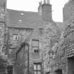
The National Trust for Scotland commissioned Alder Archaeology to carry out a Historic
Building Recording on the roof at 42-44 High Street, Linlithgow which is part of the 16th century group of buildings known as Hamilton’s Land. Hamilton’s Land is located in the centre of Linlithgow at NGR NT 00398 77131. The work was undertaken between the 3rd of October and the 1st of November 2011. The requirement was to record the nature of the original roof as it was exposed during essential repairs. The sarking was found to comprise pit-sawn Scots pine planks of a variety of lengths and widths. Stone slates had been attached to it using large headed hand forged wrought iron clout type nails. These nails were also used to nail the sarking to the rafters. The roof itself was found to be of common rafter form with most of the original rafters surviving, though a few had been reinforced or replaced with new rafters in the 19th or 20th century. All original timbers were found to be adze trimmed softwood, probably Scots pine, and most were whole though some were halved and a few quartered. Rafter pairs were connected at the apex with pegged mortise and tenon joints.
On the N roof of the property (that aligned E-W) most of the rafters were mortise and tenoned into original sole plates and ashlar posts. The sole plates on the N side rested on the external stone wall of the property, but those on the S side rested on brick walls that had been constructed on two steel I-beams. These beams had been inserted when a major internal wall in the floor below was removed in the 19th or early 20th century. Nine of the eleven rafter pairs on the N roof were connected to original collars by nailed lap joints with no dovetailing. The S roof (aligned N-S with a gable overlooking the street) was of similar design to the N though original collars had been sawn off for a modern attic conversion.
However, inspection of the stubs showed that the collars had been attached in the same manner as the N roof. In the S half of this roof the W rafters were mortised and tenoned to ashlar posts and sole plates resting on an external wall to the W. On the E, they simply abutted the party wall of the next property. Here the rafters also rested on two softwood beams that bridged a gap that was caused by the party wall being at an angle. The N half of this roof had a ridge plate which rested on a small beam inserted in between the rafters of the N roof. Rafter pairs in this part of the roof were not joined at the apex but were instead nailed to the ridge plate and each ran down to join valley timbers on either side.
On the N facing side of the N roof at either side were two sets of vertical grooves in the original rafters marking the possible location of two ‘cat slide’ type windows. A pair of cat slides were also found on either side of the S roof. Two adze trimmed bracing beams in the S roof pointed to the former existence of two dormers, one which blocked a cat slide. Later on, both of these dormers had been blocked.
Differences in collar widths and assembly marks suggested that the N roof may have stood alone prior to the construction of the S. This pointed to the possibility that Hamilton’s Land was at one stage set back from the High Street.
Archaeolical building survey of roof structure

