
Sandray


Building(S) (Period Unknown)
Site Name Sandray
Classification Building(S) (Period Unknown)
Canmore ID 21405
Site Number NL69SW 4
NGR NL 6430 9055
NGR Description From NL 642 905 to NL 643 905
Datum OSGB36 - NGR
Permalink http://canmore.org.uk/site/21405


- Council Western Isles
- Parish Barra
- Former Region Western Isles Islands Area
- Former District Western Isles
- Former County Inverness-shire
NL69SW 4 642 905 to 643 905.
(NL 6420 9059 and NL 6430 9056) Cairns (NAT) (There is no authority, in the original Name B of 1878, for the publication of this name, which also appears on the O.S. 1st. ed. 6").
OS 6" map, Inverness-shire, 2nd ed., (1904)
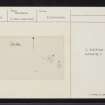
The two 'cairns' mentioned above, situated at the SEend of a rock-strewn grassy valley close to the shore line at the S. end of Sandray, approx. 25ft OD., appear to be the remains of buildings of unknown date.
"A" is a vague semi-circle, measuring 8.5m E-W, formed by a dry-stones wall of large stones, 0.7m max. height, but destroyed by coastal erosion along its S arc. Only the outer face is visible, the inner being obscured by tumble in the centre. No entrance can be seen.
"B" is a complex of 3 irregularly-shaped dry-stone constructions, 0.3m max. height, masked by tumble. The north-westerly building has an entrance in the S, and is encircled by a slight grass-covered bank of earth and rubble-stones, 0.2m high.
"C"-A grass-covered circular mound of earth and stones, 20.0m SE of B at NL 6432 9055, measures 8.0m diameter by 1.3m high, and has been robbed of stones probably for building purposes. It is possibly a cairn but bears no distinguishing features except its regular shape.
Visited by OS (N K B) 24 May 1965.
SY42: NL 6428 9057 Sub-rectangular structure, pen ?, associated with complex of walls. Also SY43: NL 6429 9056 Cairn or grassed-over circular house, 7m diameter, 1.75m high. (Presumably referring to the structures at 'B' above.)
NMRS MS 595/6, 11.

