
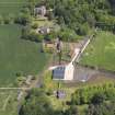
Whittingehame, Parish Church


Burial Ground (18th Century), Church (18th Century)
Site Name Whittingehame, Parish Church
Classification Burial Ground (18th Century), Church (18th Century)
Canmore ID 211284
Site Number NT67SW 85
NGR NT 60312 73665
Datum OSGB36 - NGR
Permalink http://canmore.org.uk/site/211284


- Council East Lothian
- Parish Whittingehame
- Former Region Lothian
- Former District East Lothian
- Former County East Lothian
Project (1996 - 2006)
A project recording graveyard monuments within the parish of Traprain.
Note (18 February 2025)
A church and burial ground are depicted on the 1st edition of the OS 6-inch map (1855) - Haddingtonshire, Sheet 11.
Information from HES (D Watson) 18 February 2025

