
Strichen House


Recumbent Stone Circle (Neolithic) - (Bronze Age)
Site Name Strichen House
Classification Recumbent Stone Circle (Neolithic) - (Bronze Age)
Alternative Name(s) Strichen House Policies; Strichen Stone Circle
Canmore ID 20754
Site Number NJ95SW 2
NGR NJ 93674 54479
Datum OSGB36 - NGR
Permalink http://canmore.org.uk/site/20754


- Council Aberdeenshire
- Parish Strichen
- Former Region Grampian
- Former District Banff And Buchan
- Former County Aberdeenshire
NJ95SW 2 93674 54479.
(NJ 9367 5447) Stone Circle (NR)
OS 6" map, (1959).
The remains of a recumbent stone circle, all the stones of which were removed about 1830 and some of which were replaced, but not in their original positions.
F R Coles 1904.
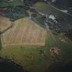
The stones of the recumbent stone circle were removed in 1965 during tree-felling operations, and are now in a pile a few metres to the SE. All that remains is a low turf-covered circular bank c 20.0m in diameter, in the S arc of which a large stone protrudes through the turf. Within the bank, and placed eccentrically, is a vague circular bank c 6.0m in diameter. The circle is located on a false crest below the summit of a rounded hill.
Revised at 1:2500.
Visited by OS (NKB) 20 March 1967.
Air photographs: AAS/94/06/G15/21-4.
NMRS, MS/712/21.
(Location cited as NJ 9367 5447: nominated as Site of Regional Significance).
This recumbent stone circle is situated on a crest at an altitude of 85m OD; the grey granite stones are of local origin. All the stones except the recumbent and its flankers were pulled down by a tenant farmer in 1830. Mr Fraser (later Lord Lovat), the landowner, ordered them to be replaced but this was done wrongly, and the circle was re-erected to the S of the recumbent. A landscaped earthern bank was built around this ring.
In 1960 every one of the stones was removed. The recumbent and flankers were subsequently replaced but taken away during tree-felling operations in 1965.
Excavations by A Burl in 1979 revealed that the original sitaution of the circle was immediately to the N, although the recumbent and its flankers were in their prehistoric location. Quartz, flints and sherds of prehistoric were found during the excavation and a cremation lay within the prehistoric bank to the NE of the recumbent. Several hammer- and rubbing-stones were found along with a cup-and-ring-marked stone which was buried in a small stone-lined pit on the N periphery of the central area. After excavation, the stones were replaced in their original positions and the circle reconstructed.
Further excavation was carried out by P Abramson in 1982 and a cremation set into the prehistoric bank of the circle has been dated by radiocarbon to 700 +/- 160 bc [reference not cited].
[Air photographic and newspaper references cited].
NMRS, MS/712/35, visited 6 August 1980.
The circle was being reconstructed during 1980-2.
Information from RCAHMS (CAA) 28 August 1985.
Re-erected by a team of volunteers in 1981.
C McKean 1990.
Publication Account (1986)
This recumbent stone circle, at 85m OD, on a false crest below the summit of a rounded Buchan hill, reflects in its history of decay the landscape changes of the past two and a half centuries. When Dr Johnson visited it in 1773, the 'druidical circle' was in woodland; approximately 20 years later a tenant farmer pulled the stones down but was forced to re-erect them by order of the landowner. Recent excavation demonstrated that the circle was re-created to the south of the original site so that the recumbent appeared, anomalously, on the north arc of the new circle. This 're-creation' was itself bulldozed away in 1965. In 1979-83 the circle was excavated and restored in its original position; a visit is now a rewarding,prehistoric, experience.
StIichen is a typical Buchan recumbent stone circle, with the stones sitting on a slight bank which forms a flattened circle, shorter north to south (12.1m by 11m). The recumbent is oriented on the extreme southern moon. One evocative discovery of the excavation was that the bank had been liberally covered with quartzite flakes, broken on site on an anvil stone.
Information from ‘Exploring Scotland’s Heritage: Grampian’, (1986).
Publication Account (1996)
This recumbent stone circle, at 85m OD, on a false crest below the summit of a rounded Buchan hill, reflects in its history of decay the land scape changes of the past two and a half centuries. When Dr Johnson visited it in 1773, the 'druidical circle' was 111 woodland; approximately 20 years later a tenant farmer pulled the stones down but was forced to re-erect them by order of the landowner. Recent excavation demonstrated that the circle was re-created to the south of the original site so that the recumbent appeared, anomalously, on the north arc of the new circle. This 're-creation' was itself bulldozed away in 1965. In 1979-83 the circle was excavated and restored in its original position; a visit is now a rewarding, prehistoric, experience.
Strichen is a typical Buchan recumbent stone circle, with the stones sitting in a slight bank which forms a flattened circle, shorter north to south (12.1m by 11m). The recumbent is oriented on the extreme southern moon. One evocative discovery of the excavation was that the bank had been liberally covered with quartzite flakes, btoken on site on an anvil stone.
Information from ‘Exploring Scotland’s Heritage: Aberdeen and North-East Scotland’, (1996).
Field Visit (21 August 2003)
As reconstructed, the circle comprises a recumbent setting and seven orthostats, standing on the line of a ring-bank to form an oval ring measuring 15.4m from ENE to WSW by 12.8m transversely overall. The recumbent (2) measures about 2.6m in length by 1.05m in height and is situated on the SSE of the ring; the uneven summit of the slab has a crudely centred shot-hole on the inner edge and a shallow cupmark to its SW. The flankers (1 & 3), which stand about 1.75m and 1.9m high respectively, are of contrasting shapes, the western being the more slender of the pair. Unusually, the leading edges of both flankers project in front of the recumbent, and that on the W with its long axis at right angles to the recumbent setting (see discussion below). One of the orthostats has now fallen (10), but the remainder have been graded in height from the flankers on the SSE down to an eccentrically placed stone only 0.7m high on the NNW (7). The ring-bank is made up largely of angular rocks and measures up to 3m in thickness by 0.35m in height; the uneven interior measures 13m from ESE to WNW by 11.5m transversely.
Visited by RCAHMS (JRS, ATW and KHJM) 21 August 2003
Measured Survey (21 August 2003)
RCAHMS surveyed Strichen House recumbent stone circle on 21 August 2003 with plane table and alidade producing a plan and section of the site and an elevation of the recumbent setting at a scale of 1:100. The survey drawing was checked on-site on 5 May 2005. The plan, section and elevation were used as the basis for an illustration, produced in ink and finished in vector graphics software, that was published at a scale of 1:250 (Welfare 2011, 455).
Measured Survey (1 May 2013)
A plan was taken to show the relationship between the original site of the recumbent stone circle and what remained of the earthen ring-bank to its south. This had been constructed to enclose the original recumbent setting and three other stones that were rearranged around a central oak tree when the ring was restored as a Druidical folly on the orders of Lord Lovat about 1830. Although the north arc of this earthwork was removed in the excavations conducted by Burl, Abramson and Hampsher-Monk from 1979 to 1982, while the remainder was de-turfed, much of its circuit still survives, with the bank measuring 2.5m thick and up to 0.4m high. In addition, the plan shows the ring-bank's relationship to the shallow quarry situated to its SE into which it would seem that the stones were cast when the monument was demolished in 1965.
Visited by RCAHMS (ATW; ARG), 1 May 2013.

