
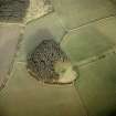
Aikey Brae


Recumbent Stone Circle (Neolithic) - (Bronze Age)
Site Name Aikey Brae
Classification Recumbent Stone Circle (Neolithic) - (Bronze Age)
Alternative Name(s) Parkhouse Hill; Aiky Brae
Canmore ID 20571
Site Number NJ94NE 4
NGR NJ 9588 4709
Datum OSGB36 - NGR
Permalink http://canmore.org.uk/site/20571


- Council Aberdeenshire
- Parish Old Deer
- Former Region Grampian
- Former District Banff And Buchan
- Former County Aberdeenshire
NJ94NE 4 9588 4709.
(NJ 9588 4709) Stone Circle (NR)
OS 6" map (1959)
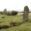
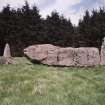
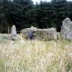
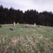
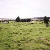
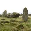
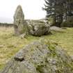
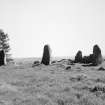
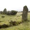
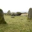
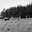
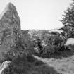
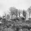
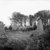
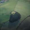
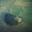
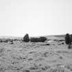
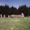
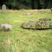
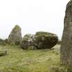
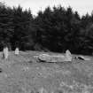
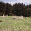
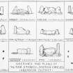
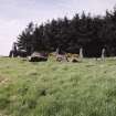
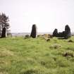
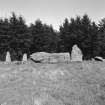
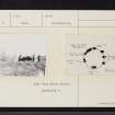
A recumbent stone circle comprising five erect stones including the 'recumbent'stone and the E pillar, and five prostrate stones including the W pillar. They are set upon a bank of small stones and earth, 5 to 6 feet wide and about 2ft 6ins high above the interior, which appears flat and grass grown. However,below the surface soil, the interior is made up, at least partially, of a mass of small boulders.
Outside the circle within a few feet to the W and S are pits apparently faced with small stones, and at a distance of 45 feet to the NE of the circle there is a harp of stones, possibly a cairn.
About 1821 a partial excavation was undertaken but nothing was found.
F R Coles 1904; J Spence 1890
A recumbent stone circle generally as described. The 'bank' appears to have been a wall about 1.2 metres wide, the inner and outer facing stones of which can be seen in parts round the circle. The alleged cairn to the NE is probably stones robbed from the circle and the pits to the W and S minor quarrying or tree holes, those on the W being in an old field bank.
Resurveyed at 1/2500.
Visited by OS (RL) 5 April 1968.
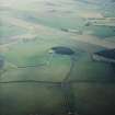
Air photographs: AAS/97/04/G8/17-18 and AAS/97/04/CT.
NMRS, MS/712/29.
NJ 9588 4709 As a continuation of the investigations at the Tomnaverie stone circle in the Howe of Cromar, Deeside (DES 2000, 9), one trench was excavated at the Buchan-type recumbent stone circle at Aikey Brae (NMRS NJ94NE 4). The trench was laid out on the W side of the monument between two monoliths of the stone circle and straddled in the wall of rubble about 1m wide that surrounds the site. This wall was found to be edged by kerbstones, some up to 1m high. The colours of the stones alternated between red and white. The kerb was bedded into a trench and charcoal samples were recovered from the base of one part of the cut. Given the excellent state of preservation of the rubble wall, this part of the structure was not removed. The socket of the southern monolith had been cut through the rubble wall and was set on its outer edge. The northern monolith was set into the centre of the wall, again cutting through the rubble. It was supported by a displaced kerbstone on its outer side. Artefacts recovered include a few worked flints and broken and flaked quartz. As seen in the recent excavations at Tomnaverie, and Cothiemuir Wood (this volume, 11), a recumbent stone circle appears to have been imposed on an earlier monument.
Sponsor: Historic Scotland
R Bradley and C Ball 2001
Publication Account (1996)
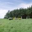
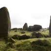
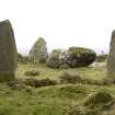
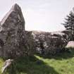
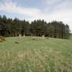
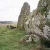
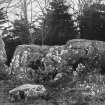
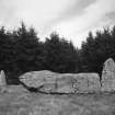
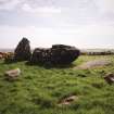
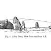
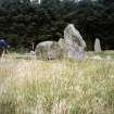
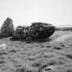
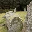
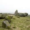
A classic hilltop circle cut into the southern rim of little Park house Hill (at 120m OD), the most intact recumbent stone circle in Buchan. It was noted, in 1858, to be 'one of the very few [circles] that the utilitarian hand of improvement has spared' (J B Pratt, Buchan). The remaining pillars of the stone ring rest on a bank of small stones and earth c 14.4m in diameter, with kerbs formed by slab-like stones on the inner and outer faces. It was a considerable feat to haul all the great stones of the ring, including the massive, whale-like recumbent (weighing 21.5 tons), into position on this bank. Such banks are a particular feature of recumbent stone circles in Buchan.
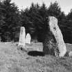
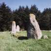
An arc of monoliths runs out from the fallen west flanker; the southern and central ones were perhaps selected for their distinctly phallic shape. These stones are exceptionally tall: the east flanker stands 2.23m high and its fallen partner on the west is 2.86m long. Clear signs that the seven stones of the ring were graded in height can still be seen.
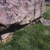
Most of the stones are of granite, but the fallen west flanker and the recumbent are of whinstone. The latter, 4.6m long, is rather uneven over its upper surface, yet overall quite level; it is beaked at the west end for ease of levering into position (cf Midmar, no. 96), but very straight at the east.
The circle's interior is slightly dished, perhaps the effects of 'excavations' conducted under the direction of Charles Elphinstone Dalrymple 'during a long summer day' many years before 1881. Remarkably little was recovered in this rather inexpert operation. In any event, the view over the recumbent to the low, open ridges of southern Buchan is enhanced.
Information from ‘Exploring Scotland’s Heritage: Aberdeen and North-East Scotland’, (1996).
Field Visit (2 August 2001)
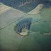
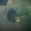
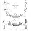
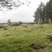
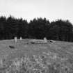
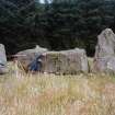
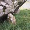
This recumbent stone circle, which is owned by Aberdeenshire Council, is situated in a grassy clearing on the S side of a coniferous plantation covering the summit of Parkhouse Hill. Measuring 16.5m from ESE to WNW by 15m transversely overall, it comprises the recumbent setting and at least six orthostats set in a ring-bank faced with kerbstones inside and out; a seventh orthostat is missing on the ENE, and the W flanker (1) and three of the orthostats (4, 5 & 6) are now prostrate. The recumbent (2), which has an uneven summit, stands on the SSW and measures up to 4.6m in length by 1.7m in height. It is held in place by three stones: one a long stone sleeper beneath its W end; the second a rounded boulder at its E end; and the third a substantial vertical slab placed at right angles to its rear, this last apparently to prevent the slab from falling backwards. The W flanker (1) has fallen across the ring-bank, and two fragments lying close by have been deliberately split from its top (1a and 1b). One antiquarian source claims that in about 1880 its counterpart on the E (3), which is some 2.1m high, was prostrate (Ferguson 1881, 105; see below), which might explain its present position set back from the leading edge of the recumbent with its inner face flush with the inner kerb of the ring-bank. Nevertheless, its foot is turned at an angle to project the arc of the kerb in a manner seen elsewhere, though in this case the outer kerb may have been carried round in front of it to the end of the recumbent. The orthostats of the circle are clearly graded from S to N, as can be seen on the W, where the tops of the three that remain upright (7–9) reduce in height from 2m to 1.6m, and the spaces between them close up from 4m to 3.2m. Excavations by Richard Bradley and Chris Ball in 2001 demonstrated that orthostats 8 and 9 had been inserted into the ring-bank on the W (Bradley 2005, 78–86), which in this sector measures between 1m and 1.5m in thickness over its kerbs. Elsewhere the ring-bank is spread up to 2.9m thick and 0.4m high, though no less than 44 kerbstones are still visible in their original positions and others lie displaced around the edge of the slightly dished interior. The excavation revealed that the kerbstones were set in trenches cut into the sub-soil and probably alternated in colour from red to white; the ring-bank was made up of angular rock fragments and may have been divided transversely by other slabs (Bradley 2005, 78–86). Apart from the fallen orthostat on the N (6) and a scatter of smaller blocks, one of which (A) has been cut down from a larger stone and may be part of the missing orthostat, the interior is featureless. Oval on plan, it measures 12m from ESE to WNW by 10m transversely, and a patch of cobbles exposed in a small cutting for a campfire at the time of the survey has since been covered back over.
Visited by RCAHMS (ATW, KHJM) 2 August 2001
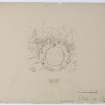
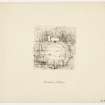
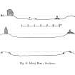
Measured Survey (31 July 2001 - 2 August 2001)
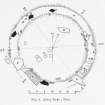
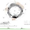
RCAHMS surveyed Aikey Brae recumbent stone circle between 31 July - 2 August 2001 with plane-table and alidade producing a plan, elevation and section at a scale of 1:100. The survey drawing was later used as the basis for an illustration produced in vector graphics software for publication at a scale of 1:250 (Welfare 2011, 275).
Field Visit (22 March 2019)
NJ 9588 4717 A walkover survey was undertaken at Parkhouse Hill woodland, located on the north side of Aikey Brae stone circle (Canmore ID: 20571), prior to tree felling and improvements to the access to the stone circle. The survey was carried out on 22nd March 2019 and a total of 11 sites were recorded. A stone-built woodland enclosure wall, several possible stone settings, banks and a stone cairn were recorded. Recommendations were made for the safeguarding of the sites during felling.
Archive: NRHE
Funder: Aberdeenshire Council
Lindsey Stirling ̶ AOC Archaeology
(Source: DES Vol 20)

