Field Visit


Date 2 August 2001
Event ID 634925
Category Recording
Type Field Visit
Permalink http://canmore.org.uk/event/634925
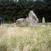
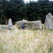
This recumbent stone circle, which is owned by Aberdeenshire Council, is situated in a grassy clearing on the S side of a coniferous plantation covering the summit of Parkhouse Hill. Measuring 16.5m from ESE to WNW by 15m transversely overall, it comprises the recumbent setting and at least six orthostats set in a ring-bank faced with kerbstones inside and out; a seventh orthostat is missing on the ENE, and the W flanker (1) and three of the orthostats (4, 5 & 6) are now prostrate. The recumbent (2), which has an uneven summit, stands on the SSW and measures up to 4.6m in length by 1.7m in height. It is held in place by three stones: one a long stone sleeper beneath its W end; the second a rounded boulder at its E end; and the third a substantial vertical slab placed at right angles to its rear, this last apparently to prevent the slab from falling backwards. The W flanker (1) has fallen across the ring-bank, and two fragments lying close by have been deliberately split from its top (1a and 1b). One antiquarian source claims that in about 1880 its counterpart on the E (3), which is some 2.1m high, was prostrate (Ferguson 1881, 105; see below), which might explain its present position set back from the leading edge of the recumbent with its inner face flush with the inner kerb of the ring-bank. Nevertheless, its foot is turned at an angle to project the arc of the kerb in a manner seen elsewhere, though in this case the outer kerb may have been carried round in front of it to the end of the recumbent. The orthostats of the circle are clearly graded from S to N, as can be seen on the W, where the tops of the three that remain upright (7–9) reduce in height from 2m to 1.6m, and the spaces between them close up from 4m to 3.2m. Excavations by Richard Bradley and Chris Ball in 2001 demonstrated that orthostats 8 and 9 had been inserted into the ring-bank on the W (Bradley 2005, 78–86), which in this sector measures between 1m and 1.5m in thickness over its kerbs. Elsewhere the ring-bank is spread up to 2.9m thick and 0.4m high, though no less than 44 kerbstones are still visible in their original positions and others lie displaced around the edge of the slightly dished interior. The excavation revealed that the kerbstones were set in trenches cut into the sub-soil and probably alternated in colour from red to white; the ring-bank was made up of angular rock fragments and may have been divided transversely by other slabs (Bradley 2005, 78–86). Apart from the fallen orthostat on the N (6) and a scatter of smaller blocks, one of which (A) has been cut down from a larger stone and may be part of the missing orthostat, the interior is featureless. Oval on plan, it measures 12m from ESE to WNW by 10m transversely, and a patch of cobbles exposed in a small cutting for a campfire at the time of the survey has since been covered back over.
Visited by RCAHMS (ATW, KHJM) 2 August 2001