
Girvan Harbour


Harbour (Period Unassigned)
Site Name Girvan Harbour
Classification Harbour (Period Unassigned)
Alternative Name(s) Girvan, Harbour; Water Of Girvan
Canmore ID 203289
Site Number NX19NE 75
NGR NX 18196 98250
NGR Description Centred NX 18196 98250
Datum OSGB36 - NGR
Permalink http://canmore.org.uk/site/203289


- Council South Ayrshire
- Parish Girvan
- Former Region Strathclyde
- Former District Kyle And Carrick
- Former County Ayrshire
NX19NE 75.00 centred 18196 98250
Harbour [NAT] (at NX 181 982)
OS (GIS) MasterMap, July 2009.
NX19NE 75.01 NX 17973 98323 to NX c. 18087 98230 South Pier (Breakwater)
NX19NE 75.02 NX 17972 98322 South Pier, Beacon ('Harbour Light')
NX19NE 75.03 NX 18030 98342 to NX c. 18244 98408 North Pier (Breakwater)
NX19NE 75.04 NX 18031 98343 North Pier, Beacon ('Reflector')
NX19NE 75.05 NX 18336 98169 to NX c. 18400 98134 to NX c. 18420 98086 Timber Jetty
NX19NE 75.06 NX 18429 98079 Lifeboat Station (Knockcushan Street)
NX19NE 75.07 NX 18359 98198 Slipway (Newton Kennedy)
NX19NE 75.08 NX 18377 98193 Coastguard Station (Newton Kennedy)
NX19NE 75.09 NX 18168 98281 Inner Breakwater, Beacon
NX19NE 75.10 NX 18168 98281 to NX c. 18254 98288 Inner Breakwater (Old North Breakwater)
NX19NE 75.11 NX c. 1817 9823 Beacon ('Block Signal')
Location formerly entered as NX 1819 9822.
For adjacent 'fort of earth' [earthwork], see NX19NE 16.
For (associated) Girvan, Newton Kennedy, Boatbuilding Yard (centred NX 18490 98170), see NX19NE 138.
For former railway bridge (allowing access to the harbour), see NX19NE 175.
For Newton Kennedy Bridge (at upper limit of harbour), see NX19NE 176.
Harbour [NAT] (centred NX 18177 98260)
OS (GIS) AIB, June 2006.
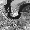
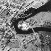
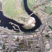
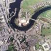
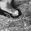
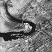
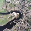
(Location cited as NX 183 982). Girvan Harbour, rebuilt 1869-70 and extended in 1881-3. A rivermouth harbour, with quays on the S bank, protected by a concrete breakwater with a small light-tower at the seaward end (1881-3). A relatively recent addition is an L-plan piled pier in the inner harbour, giving increased berthage. There was a coal quay on the N bank, but this has been demolished.
J R Hume 1976.
(Location cited as NX 18 98). The old town of Girvan [NX19NE 44] stood on the left bank of the Girvan Water where its lowermost reach curves from S and [at NS c. 1839 9814] straightens out westwards to finish its course to the sea. It was the seaward part of this reach that formed the original harbour. Abercromby noted the place in 1683 as a 'receptacle' for boats from Ireland and the Highlands, and he regarded it as better than the neighbouring sites at Turnberry Bay [name: NS 194 062] and the mouths of the Doon [location: NS 32 19] and Stinchar [location: NX 07 81], which he put in a similar class. Tucker had previously (1655) noted Girvan as a 'creek', no doubt in the sense of a subordinate Customs station. In 1794, while it was still unimproved, the harbour was considered reasonable, as its entrance gave from 9ft [2.7m] to 11ft [3.4m] of water at high tides and vessels were able to get out in all moderate winds. It was suggested at that time that improvements could be made, and that deeper water could be obtained if a quay was built. Profits accruing from a glut of herrings which occurred in the 1760's, as well as from the contraband trade, had resulted in the growth of what had previously been a very small town; though at the date of writing only a single boat of more than 20 tons was owned in or worked from the place, and the craft used in coastwise trade or in the smuggling of slat from Ireland were small and open, or half-decked. By 1837 a 'quay on a very limited scale' was constructed, which improved conditions for the trade in coal and grain, and further improvement was 'contemplated'. Further improvement was recorded in 1847. The harbour could accommodate vessels up to 10ft [3m] draught, and Girvan ranked as a large fishing-station, supporting 34 boats and 90 men.
The harbour of today lacks such distinctive features as would help in the dating of its individual components. The most important of these is, of course, the pier [NX19NE 75.01], which runs out north-westwards, to a length of 170yds [156m] along the estuary's left [S] bank. It is ashlar rendered in cement, and carries a protective wall on its seaward side and a light [NX19NE 75.02] at its outer end, which forms one side of the entrance. The entrance [location: NX 1800 9833] is very narrow, and on its opposite side there stands the round-ended fragment of a ruined breakwater [NX19NE 75.03], some remains of which appear at low tide as a rickle of stones bearing two or three lumps of built masonry not yet completely destroyed. This work occupies a low, rocky spit projecting from the boulder-strewn N shore of the estuary, and no doubt served to protect the harbour from the N. At the landward end of the pier there is a small shapeless inlet [centred NX 1819 9835] now full of boulders and with the stumps of a row of posts crossing its entrance; impinging on it from upstream there can be seen a masonry ledge with a curved end, which may perhaps represent the former terminal point of a system of wharfage antedating the constreuction of the pier.
Upstream again from the inlet, the riverbank is faced with sections of wharfage in slightly different alignments; in particular, the block of ground now devoted to a car park helps to shelter the lower part of a pool used by fishing-boats and yachts. On its upstream side, this pool is also partially enclosed by a timber jetty [NX19NE 75.05] which runs out into the estuary on a diagonal but curving line; this post-dates the map of 1856 but is marked 'Screen' on that of 1963. No doubt, it acts a baffle in times of flood, and may concentrate the current and improve its scouring effect. The wharves and buildings now seen on the estuary's right [N] bank are all later than 1856.
A Graham 1984.
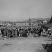
Photographic Survey (1900 - 1930)
Photographs by A Brown & Co of sites across Scotland c1900-1930

