Accessibility

Font Size

100% 150% 200%

Background Colour

Default Contrast
Close Reset

Eigg, Poll Duchaill

Fort (Prehistoric), House Platform (Medieval) - (18th Century)

Site Name Eigg, Poll Duchaill

Classification Fort (Prehistoric), House Platform (Medieval) - (18th Century)

Canmore ID 202968

Site Number NM48NE 51

NGR NM 4543 8816

Datum OSGB36 - NGR

Permalink http://canmore.org.uk/site/202968

Ordnance Survey licence number AC0000807262. All rights reserved.
Canmore Disclaimer. © Bluesky International Limited 2025. Public Sector Viewing Terms

Toggle Aerial | View on large map

Digital Images

General oblique aerial view of the west side of Eigg with the fort in the foreground and the Sgurr fort beyond, taken from the NW.
General oblique aerial view of the west side of Eigg with the fort in the foreground and the Sgurr fort beyond, taken from the NW.General oblique aerial view of the west side of Eigg with the fort in the foreground and the Sgurr fort beyond, taken from the NNW.General oblique aerial view of the west side of Eigg with the fort in the foreground and the Sgurr fort beyond, taken from the NW.Eigg, Poll Duchaill, Fort. View from S.Eigg, Poll Duchaill, Fort. View from S.Eigg, Poll Duchaill, Fort. View from W.Oblique aerial view centred on the remains of the fort, taken from the SW.Eigg, Poll Duchaill, Fort. View from S.Looking out of entranceGeneral oblique aerial view of the west side of Eigg with the fort in the foreground and the Sgurr fort beyond, taken from the NNW.General viewGeneral oblique aerial view centred on the Bay of Laig with the crofting township beyond and the remains of the fort adjacent, taken from the W.General oblique aerial view of the remains of the fort with Rum in the distance, taken from the ESE.General oblique aerial view of the remains of the fort with Rum in the distance, taken from the ESE.General oblique aerial view centred on the Bay of Laig with the remains of the fort beyond, taken from the ENE.General oblique aerial view looking across Laig Bay, with the fort in the foreground, towards Cleadale and the north side of Eigg, taken from the W.Archaeological map of Eigg, produced for the RCAHMS Broadsheet Eigg: the archaeology of a Hebridean landscapeEigg, Poll Duchaill, Fort. View from S.Eigg, Poll Duchaill, Fort. View from S.Eigg, Poll Duchaill, Fort. View from S of fragment of W wall.Eigg, Poll Duchaill, Fort. View from S of fragment of W wall.RCAHMS survey drawing; plan of Poll Duchaill fort.Eigg, Poll Duchaill, Fort. View from S.Eigg, Poll Duchaill, Fort. View from S.Eigg, Poll Duchaill, Fort. View from S.Eigg, Poll Duchaill, Fort. View from S.Eigg, Poll Duchaill, Fort. View from S of fragment of W wall.Eigg, Poll Duchaill, Fort. View from S of fragment of W wall.Eigg, Poll Duchaill, Fort. View from S of fragment of W wall.General oblique aerial view of the remains of the fort with Rum in the distance, taken from the ESE.Oblique aerial view centred on the remains of the fort, taken from the W.RCAHMS inked drawing; plan of fort, Poll DuchaillEigg, Poll Duchaill, Fort. View from W.Eigg, Poll Duchaill, Fort. View from S.Eigg, Poll Duchaill, Fort. View from S.General oblique aerial view of the Bay of Laig, Eigg, taken from the W.Plan of Poll Duchaill fort. HES publication illustration.Eigg, Poll Duchaill, Fort. View from S.General oblique aerial view looking across Laig Bay, with the fort in the foreground, towards Cleadale and the north side of Eigg, taken from the WNW.Oblique aerial view of Laig, Isle of Eigg, looking SW.Eigg, Poll Duchaill, Fort. View from S of W wall.Eigg, Poll Duchaill, Fort. View of entrance from NE.View of the fort, Poll Duchaill, Eigg, with the hills of Rhum in the background.General oblique aerial view centred on the Bay of Laig with the remains of the fort beyond, taken from the ENE.General oblique aerial view looking across Laig Bay, with the fort in the foreground, towards Cleadale and the north side of Eigg, taken from the WNW.Eigg, Poll Duchaill, Fort. View from S.Eigg, Poll Duchaill, Fort. View from W.Eigg, Poll Duchaill, Fort. View of entrance from S.Oblique aerial view centred on the remains of the fort, taken from the W.General viewOblique aerial view centred on the remains of the fort, taken from the SW.Eigg, Poll Duchaill, Fort. View from W.Eigg, Poll Duchaill, Fort. View of section of W wall.Eigg, Poll Duchaill, Fort. View of entrance from S.Eigg, Poll Duchaill, Fort. View from S of W wall.Eigg, Poll Duchaill, Fort. Section of walling.Looking out of entranceGeneral oblique aerial view centred on the Bay of Laig with the crofting township beyond and the remains of the fort adjacent, taken from the W.General oblique aerial view centred on the Bay of Laig with the crofting township beyond and the remains of the fort adjacent, taken from the W.Eigg, Poll Duchaill, Fort. View from S.Eigg, Poll Duchaill, Fort. View from S of fragment of W wall.Eigg, Poll Duchaill, Fort. View from S of fragment of W wall.Eigg, Poll Duchaill, Fort. View of entrance from S.Eigg, Poll Duchaill, view of the remains of a fort.Digital photograph: General view of fort, Poll DuchaillEigg, Poll Duchaill, Fort. View from W.RCAHMS staff at Poll DochaillGeneral viewGeneral oblique aerial view centred on the Bay of Laig with the crofting township beyond and the remains of the fort adjacent, taken from the W.General oblique aerial view centred on the Bay of Laig with the remains of the fort beyond, taken from the ENE.General view centred on the fort at Poll Duchaill. Eigg, Poll Duchaill, Fort. Section of walling.Eigg, Poll Duchaill, Fort. View of entrance from N.

Administrative Areas

  • Council Highland
  • Parish Small Isles
  • Former Region Highland
  • Former District Lochaber
  • Former County Inverness-shire

Archaeology Notes

NM48NE 51 4543 8816

Further information to follow from RCAHMS Eigg Survey.

RCAHMS (SDB) 28 November 2001.

Activities

Field Visit (30 August 2001)

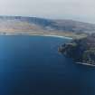
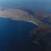
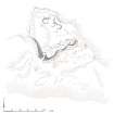
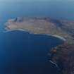
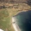
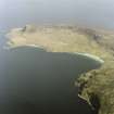
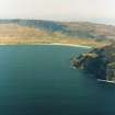
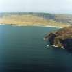
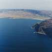
This fort is situated upon a roughly triangular, cliff-girt knoll overlooking the island of Rhum to the N and the Bay of Laig to the E. These natural defences are further strengthened by a deep gully on the S, which contains outcropping rocky ridges. The fort measures about 55m from NW to SE by 50m transversely, within cliff edges on the NE and W and grass-grown, faced-rubble walls up to 3m thick and 1m high on the SW and SE. A foundation course emerging from the external face of these walls at a lower level on the SW, produces a funnel-shaped entrance that narrows to about 1m wide. A terraced path ascending the rocky scarp from the gully may once have made for a second entrance roughly centred in the SE wall, while another path approaching via the cliff top on the E heads for an entrance in the gap at the end of this wall that is possibly of relatively recent origin.

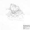
The interior of the fort, which consists of broken ground that slopes gently N, contains traces of at least eight circular hut platforms. In addition, there is a later quarry that interrupts access to the SW entrance and traces of further quarrying occur on the ridges within the gully.

(EIGG01 250)

Visited by RCAHMS (AGCH, DCC) 30 August 2001

Measured Survey (31 August 2001)

RCAHMS surveyed the fort at Poll Duchaill on 31 August 2001 with plane table and self-reducing alidade at a scale of 1:1000. The plan was redrawn in ink and later used as the basis of an illustration published in 2016 (Hunter, fig. 3.13).

Note (12 November 2014 - 23 May 2016)

This fort occupies a rugged promontory which projects from the coastal escarpment high above the shore to the W of Laig Bay. While overlooked by the cliffs to the S, it is nevertheless a strong position with a deep natural gully across its neck on the SE. The remains of a wall can be traced along the SE flank of the promontory's summit overlooking the gully, turning sharply back at the S corner to peter out on the W flank. Occasional outer facing- stones can be seen along its line, including a few set rather further down the slope at the southern corner where they possibly indicate an outer line of defence enhancing the protection of a natural ramp leading up to the entrance. The interior, which measures about 60m from NW SE by a maximum of 50m transversely (0.25ha), is rough and uneven but at least six circular house platforms have been dug into the slope.

Information from An Atlas of Hillforts of Great Britain and Ireland – 23 May 2016. Atlas of Hillforts SC2524

References

MyCanmore Image Contributions


Contribute an Image

MyCanmore Text Contributions