
Strath Howe


Promontory Fort (Period Unassigned)
Site Name Strath Howe
Classification Promontory Fort (Period Unassigned)
Alternative Name(s) Tore Of Troup
Canmore ID 19978
Site Number NJ86SW 8
NGR NJ 840 611
Datum OSGB36 - NGR
Permalink http://canmore.org.uk/site/19978


- Council Aberdeenshire
- Parish Aberdour (Banff And Buchan)
- Former Region Grampian
- Former District Banff And Buchan
- Former County Aberdeenshire
NJ86SW 8 840 611.
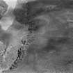
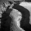
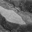
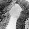
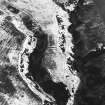
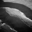
On the east side of the Tore of Troup a pair of ditches traverse a horsebacked promontory between two dens creating an enclosure c.140m NE-SW by c.5 0m transversely.
I A G Shepherd and I B M Ralston 1982.
(Location cited as NJ 8400 6118; nominated as Site of Regional Significance). This promontory fort is situated at an altitude of 70m OD on the E side of the Tore of Troup.
(Air photographic imagery listed).
NMRS, MS/712/35 and MS/712/36, visited 9 April 1981.
Note (28 April 2015 - 18 May 2016)
Aerial photography has revealed a ploughed-down earthwork cutting across the neck of a steep-sided promontory between two burn gullies that ultimately feed into the Tore of Troup via Stonny Burn. An irregular tongue of roughly level ground, the margins of the summit are defined by low banks that have the appearance of old field boundaries, and it is possible that the ploughed down earthwork, which apparently comprises twin ditches with a medial bank cutting across the narrow neck on the NE, are the remains of a post-medieval field boundary rather than the defences of a fort. Nevertheless, the featureless interior, which has evidently been cultivated on several occasions in the past, measures about 160m in length from NE to SW by a maximum of 65m transversely (0.69ha). There are traces of a trackway hollow extending along the axis of the promontory, but no evidence of an original entrance.
Information from An Atlas of Hillforts of Great Britain and Ireland – 18 May 2016. Atlas of Hillforts SC2984

