|
Photographs and Off-line Digital Images |
D 83029 PO |
Records of Aberdeen Aerial Surveys, Aberdeen, Scotland |
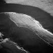
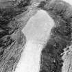
Strath Howe (Tore of Troup), promontory fort: aerial view. |
23/8/1981 |
Item Level |
|
|
Photographs and Off-line Digital Images |
D 98016 PO |
Records of Aberdeen Aerial Surveys, Aberdeen, Scotland |
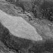
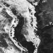
Strath Howe (Tore of Troup), promontory fort: oblique air photograph under snow. |
15/1/1982 |
Item Level |
|
|
Manuscripts |
MS 712/35 |
Records of Aberdeenshire Archaeology Service, Aberdeen, Scotland |
Photocopies of updates to Aberdeenshire Archaeological Service (formerly Grampian Regional Council) SMR, relating to sites, finds and monuments within area of former Grampian Region, received September 1998. |
1998 |
Item Level |
|
|
Manuscripts |
MS 712/36 |
Records of Aberdeenshire Archaeology Service, Aberdeen, Scotland |
Photocopies of updates to Aberdeenshire Archaeological Service (formerly Grampian Regional Council) SMR, relating to sites, finds and monuments within area of former Grampian Region, received April 1997 (with supplementary information and covering letter). |
1997 |
Item Level |
|
 |
On-line Digital Images |
SC 1010659 |
Records of Aberdeen Aerial Surveys, Aberdeen, Scotland |
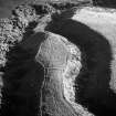
Oblique aerial view centred on the remains of the promontory fort at Strath Howe, looking to the W. |
10/8/1985 |
Item Level |
|
 |
On-line Digital Images |
SC 1010660 |
Records of Aberdeen Aerial Surveys, Aberdeen, Scotland |
Oblique aerial view centred on the remains of the promontory fort at Strath Howe, looking to the SW. |
10/8/1985 |
Item Level |
|
 |
On-line Digital Images |
SC 1012669 |
Records of Aberdeen Aerial Surveys, Aberdeen, Scotland |
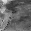
Oblique aerial view centred on the remains of the promontory fort and hut circles at Glenhouses and Strath Howe, looking to the NE. |
23/8/1980 |
Item Level |
|
 |
On-line Digital Images |
SC 1012678 |
Records of Aberdeen Aerial Surveys, Aberdeen, Scotland |
Oblique aerial view centred on the remains of the promontory fort at Strath Howe, looking to the SE. |
23/8/1980 |
Item Level |
|
 |
On-line Digital Images |
SC 1936828 |
Records of Aberdeen Aerial Surveys, Aberdeen, Scotland |
Strath Howe (Tore of Troup), promontory fort: aerial view. |
23/8/1981 |
Item Level |
|
 |
On-line Digital Images |
SC 1936836 |
Records of Aberdeen Aerial Surveys, Aberdeen, Scotland |
Strath Howe (Tore of Troup), promontory fort: oblique air photograph under snow. |
15/1/1982 |
Item Level |
|
 |
On-line Digital Images |
SC 2378036 |
Records of the Ordnance Survey, Southampton, Hampshire, England |
Strath Howe, NJ86SW 8, Ordnance Survey index card, Recto |
c. 1958 |
Item Level |
|


