Accessibility

Font Size

100% 150% 200%

Background Colour

Default Contrast
Close Reset

Bonnington Hydro-electric Power Station

Hydroelectric Power Station (20th Century)

Site Name Bonnington Hydro-electric Power Station

Classification Hydroelectric Power Station (20th Century)

Alternative Name(s) Bonnington Hydro-electric Scheme; River Clyde; Corra Linn; Bonnington Linn; Falls Of Clyde

Canmore ID 199381

Site Number NS84SE 131

NGR NS 88397 41672

Datum OSGB36 - NGR

Permalink http://canmore.org.uk/site/199381

Ordnance Survey licence number AC0000807262. All rights reserved.
Canmore Disclaimer. © Bluesky International Limited 2025. Public Sector Viewing Terms

Toggle Aerial | View on large map

Digital Images

Oblique aerial view of Corchouse with Bonnington Power Station adjacent, taken from the W.
Oblique aerial view of Corchouse with Bonnington Power Station adjacent, taken from the W.Tunnel at surge tank end.
Photographic copy of Plate 25, Volume 198, PA 123.Power house.
Photographic copy of Plate 35, Volume 198, PA 123.Tilting weir and intake screens.
Photographic copy of Plate 42, Volume 198, PA 123.Air vent pipes
Photographic copy of Plate 44, Volume 198, PA 123.Oblique aerial view of Bonnington hydroelectric power station, taken from the E.View of W side from NNW.View of E side from NE.Interior. View of control panel from E.Interior. View of control panel from E.Interior. View of N end of turbine hallOblique aerial view centred on Bonnington power station with pavilion adjacent, taken from the WNW.View of E side from NE.Oblique aerial view centred on Corehouse and power station with New Lanark adjacent, taken from the SE.
General view in snow.Oblique aerial view centred on Corehouse and power station with New Lanark adjacent, taken from the SE.Power house viewed from Corehouse side.
Photographic copy of Plate 49, Volume 198, PA 123.View of structure showing reinforcing steel.
Photographic copy of Plate 6, Volume 198, PA 123.Building and pipe track.
Photographic copy of Plate 18, Volume 198, PA 123.Placing concrete liner segments in position from surge tank end. Under gardens..
Photographic copy of Plate 51, Volume 198, PA 123.Working face.
Photographic copy of Plate 54, Volume 198, PA 123.Aqueduct. Work in open cut
Photographic copy of Plate 55, Volume 198, PA 123.View of Bonnington hydroelectric power station from SEGeneral oblique aerial view centred on Corehouse country house and Bonnington power station with New Lanark village beyond, taken from the S.Oblique aerial view of Bonnington Hydro-Electric Power Station, taken from the S.View of station house from S.Falls of Clyde map, from RCAHMS Falls of Clyde Broadsheet 14Oblique aerial view centred on Corehouse with power station adjacent, taken from the SW.Oblique aerial view centred on Bonnington power station with pavilion adjacent, taken from the NW.Oblique aerial view centred on Corehouse, the power station and pavilion, taken from the WNW.View from NE.View up pipeline from NW.General view from E.View from S showing part of S and E frontsTilting weir at Tulliford.
Photographic copy of Plate 42, Volume 198, PA 123.Soft tunnel heading.
Photographic copy of Plate 44, Volume 198, PA 123.Tunnel.
Photographic copy of Plate 57, Volume 198, PA 123.View up pipeline from NW.General view from E.Oblique aerial view centred on Bonnington power station with pavilion adjacent, taken from the NW.View of W side from NNW.View of station house from S.View from ESE.View of pipeline from NNW.Interior. View of turbine hall from N.Interior. View of control panel from E.Bonnington Power StationView showing work at surge tank and watch tower.
Photographic copy of Plate 9, Volume 198, PA 123, Scottish Power Collection.General view of Bonnington hydroelectric power station from NWShowing line of pipe track.
Photographic copy of Plate 25, Volume 198, PA 123.Placing concrete liner segments in position from surge tank end. Under gardens..
Photographic copy of Plate 50, Volume 198, PA 123.Interior. View of turbine hall from N.View from E.Oblique aerial view centred on Corehouse, the power station and pavilion, taken from the W.View from SE.View from E.Sectional Elevation of Stonebyres Hydro-Electric Unit-2840 KW and Elevation of Bonnington Hydro-Electric Unit-4920 KW; copied from pages 4 and 5 of the booklet 'Harnessing the Falls of Clyde'.
Copy of Black and white negative.
Showing intake works at Tulliford.
Photographic copy of Plate 14, Volume 198, PA 123.Intake works.
Photographic copy of Plate 33, Volume 198, PA 123.General oblique aerial view centred on Corehouse country house with the Bonnington power station beyond, taken from the SSW.View of outflow on W side from NNW.Interior view of Bonnington hydroelectric power station showing turbine hall from N, including worker.Oblique aerial view centred on Corehouse with power station adjacent, taken from the WSW.General view from NW.Interior. View of turbine hall from N.Interior. View of turbine hall from N, including worker .General view from E.Inflow pipelines to BonningtonScanned image of oblique aerial photograph of Bonnington Power Station, taken from the NW.View of structure showing work at surge tank and watch tower, Bonnington Power Station in 1926.
View from W, from opposite bank.
Scanned image of Plate 49, Volume 198, PA 123.View from ESE.Oblique aerial view centred on Corehouse with power station adjacent, taken from the WSW.View of outflow on W side from NNW.View of E side from NE.View from ESE.View up pipeline from NW.Interior. View of control panel from E.Interior. View of control panel from E.View from E.Interior.
View showing Hydro-Electric Unit.
Scanned image of Plate 19, Volume 197, PA 123.Bird's eye view looking into surge tank.
Photographic copy of Plate 13, Volume 198, PA 123.Surge tank operating gear for sluices.
Photographic copy of Plate 59, Volume 198, PA 123.General oblique aerial view centred on Corehouse country house with the Bonnington power station beyond, taken from the SSW.Oblique aerial view of Bonnington Hydro-Electric Power Station, taken from the N.Oblique aerial view of Corehouse Country House, taken from the W.Oblique aerial view of Corehouse Country House, taken from the SW.Oblique aerial view of Corehouse Country House, taken from the SSW.View from NE.View of pipeline from NNW.View of W side from NNW.View of station house from S.Interior. View of control panel from E.View from SSE showing E front and part of S frontFront cover illustration of the booklet, 'Harnessing the Falls of Clyde' displaying the logo of the Clyde Valley Electrical Power Company above a stylised motif of cascading water.


Profile at tunnel mouth.
Photographic copy of Plate 16, Volume 198, PA 123.View of intake works, Bonnington hydro-electric power station in 1926.
Oblique aerial view centred on Corehouse with power station and pavilion adjacent, taken from the W.Oblique aerial view centred on Corehouse with power station adjacent, taken from the WSW.View from NE.View of pipeline from NNW.

First 100 images shown. See the Collections panel (below) for a link to all digital images.

Administrative Areas

  • Council South Lanarkshire
  • Parish Lanark
  • Former Region Strathclyde
  • Former District Clydesdale
  • Former County Lanarkshire

Archaeology Notes

NS84SE 131.00 88397 41672

Location formerly cited as NS 8840 4167, and as centred NS 88397 41672.

Not to be confused with Stonebyres Hydro-electric Power Station (NS 85023 44157), for which see NS84SE 99.00.

NS84SE 131.01 c.NS 8849 4147 to NS c. 8846 4072 Aqueduct

NS84SE 131.02 NS 88496 41447 Surge tank

NS84SE 131.03 c.NS 8849 4147 to NS c. 8841 4166 Pipeline

NS84SE 131.04 NS 88471 40682 Weir; Footbridge

Power Station [NAT]

OS 1:10,000 map, 1985.

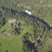
(Location cited as NS 883 417). Bonnington Power Station, built 1927 by the Clyde Valley Electrical Power Co Ltd. A tall, single-storey, 3- by 7-bay, reinforced-concrete building with round-headed windows, and ancillary 3- and 2-storey blocks in similar style. Stonebyres (NS 850 442) is very similar.

J R Hume 1976.

This power station is situated on the E bank of the River Clyde, about 0.5km downstream from Corra Linn [name: NS 8834 4144] and Bonnington Linn [name: NS 8834 4056].

Information from RCAHMS (RJCM), 23 February 2006.

Activities

Construction (December 1927)

Commissioned mid 1920s and opened December 1927. Intake regulated by tilting weirs. 9.8KW electricity generated on opening.

Project (2007)

This project was undertaken to input site information listed in 'Civil engineering heritage: Scotland - Lowlands and Borders' by R Paxton and J Shipway, 2007.

Publication Account (2007)

The Bonnington Hydro scheme on the Clyde, about four miles from Lanark, was constructed in the mid-1920s and opened in December 1927. It was the first major hydroelectric project for the public supply of electricity in Scotland. The scheme utilises the head or height of water provided by two of the Falls of Clyde, Bonnington Linn and Cora Linn. Water is abstracted at intakes above the falls by automatically adjusted tilting weirs, and conveyed by tunnels 10 ft in diameter, totalling some 1200 yards in length, to the power station downstream where twin turbo-alternators produce 9.8MW of electricity. The working head of water in the Bonnington scheme is 189 ft, and for Stonebyres, 98 ft.

The project was designed by Buchan & Partners of Edinburgh, and the contractors were Sir William Arrol & Co., and the English Electric Company.

R Paxton and S Shipway 2007

Reproduced from 'Civil Engineering heritage: Scotland - Lowlands and Borders' with kind permission of Thomas Telford Publishers.

Field Visit (2010)

Built during 1926 and commissioned in 1927 this is the first of two powerhouses operating as run of the river schemes on the upper reaches of the River Clyde. The technical concept was designed by Edward McColl and the engineering specification produced by Buchan and Partners of Edinburgh. The civil engineering was undertaken by Sir William Arrol and Co. the powerhouse comprises two vertical shaft generators with Francis turbines connected to 11,000 KW generators. The Falls of Clyde scheme is an important example of the earliest large scale application of hydroelectric power for public supply in Scotland The scheme consist of two powerhouse each with an associated weir operating as run of the river schemes. All elements of the scheme are design cohesively in a modern classical style which was very influential over later developments such as the Rannoch / Tummel scheme. Buchan & Partners, Engineers, Ground plans and sections of Lanarkshire hydro-electric power schemes near Bonnington and near Nemphlar and Stonebyres Falls (1923-1924) NAS Reference, RHP 43551. Clyde Valley Electrical Power Co., 1926; J R Hume, 1976; Archive, Issue 14, 1997.

References

MyCanmore Image Contributions


Contribute an Image

MyCanmore Text Contributions