
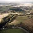
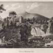
Bonnington Linn


Waterfall (Period Unassigned)
Site Name Bonnington Linn
Classification Waterfall (Period Unassigned)
Alternative Name(s) Bonnington Lynn; Falls Of Clyde; River Clyde
Canmore ID 199372
Site Number NS84SE 130
NGR NS 88336 40589
NGR Description Centred on NS 8836 40589
Datum OSGB36 - NGR
Permalink http://canmore.org.uk/site/199372


- Council South Lanarkshire
- Parish Lesmahagow
- Former Region Strathclyde
- Former District Clydesdale
- Former County Lanarkshire
NMRS REFERENCE:
The River Clyde here forms the boundary between the parishes of Lanark and Lesmahagow.
(Undated) information in NMRS.
Photographic Record (1865 - 1867)
Photograph album with photos compiled and photographed by J McGhie, Hamilton.

