
Glasgow, Springfield Quay


Quay (19th Century)
Site Name Glasgow, Springfield Quay
Classification Quay (19th Century)
Canmore ID 196598
Site Number NS56SE 1411
NGR NS 5787 6480
Datum OSGB36 - NGR
Permalink http://canmore.org.uk/site/196598


- Council Glasgow, City Of
- Parish Govan (City Of Glasgow)
- Former Region Strathclyde
- Former District City Of Glasgow
- Former County Lanarkshire
Desk Based Assessment (16 June 2017)
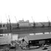
Springfield Quay is located on the S bank of the River Clyde opposite Anderston Quay and is depicted on the 1:500 OS Town Plan of Glasgow (1857, VI.10.18). A long range of roofed structures measuring 225m long by 15m transversely is recorded, most likely good sheds, and two ferry crossings at either end of the quay are indicated by sets of steps descending to the waterline on both banks. The 1:500 OS town plan of 1893 (Glasgow, Sheet VI.10.18) indicates that the goods sheds had been replaced with a series of rail or tram tracks, eight hydraulic capstans, a travelling crane, mooring posts and a customs office. The ferry to the west had gone by this time, but that to the east remained, annotated as the ‘Clyde Street Ferry’. During this time much work was being undertaken to deepen the Clyde and by 1871 a minimum depth of 22ft at high water was available between Greenock and the Broomielaw Quays, a distance of 22 miles. In 1867 the Kingston Dock, immediately west of Springfield Quay was opened, the first dock outwith the river basin. The area is now a recently developed entertainment complex immediately west of the Kingston Bridge (NS56SE 104).
Information from HES Survey and Recording (AMcC) 16 June 2017.

