|
Manuscripts |
MS 712/79 |
Records of Aberdeenshire Archaeology Service, Aberdeen, Scotland
|
Photocopies of Aberdeenshire Archaeological Service site record sheets for map sheets NJ81SW and NJ81SE, received 5 March 1999. |
1999 |
Item Level |
|
|
Prints and Drawings |
ABD 221/1 |
|
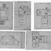
Ground and attic floor plans of church. Basement, ground and first floor plans of manse. |
1926 |
Item Level |
|
 |
On-line Digital Images |
SC 929090 |
|
Scanned image of 5 drawings showing ground and attic floor plans of church and basement, ground and first floor plans of manse. |
1926 |
Item Level |
|
|
Photographs and Off-line Digital Images |
D 32058 |
|
Photographic copy of 5 drawings showing ground and attic floor plans of church and basement, ground and first floor plans of manse. |
1926 |
Item Level |
|
|
Digital Files (Non-image) |
GV 004697 |
Records of the Royal Commission on the Ancient and Historical Monuments of Scotland (RCAHMS), Edinbu |
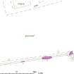
RCAHMS publication drawing: plan of Kinellar Parish Church stone circle (possible) |
|
Item Level |
|
|
Photographs and Off-line Digital Images |
DP 119920 |
Buildings at Risk Register |
Kinellar Parish Church (Former) West elevation |
28/10/2010 |
Item Level |
|
|
Photographs and Off-line Digital Images |
DP 119921 |
Buildings at Risk Register |
Kinellar Parish Church (Former) West/ south elevations |
1/3/2004 |
Item Level |
|
|
Photographs and Off-line Digital Images |
DP 119922 |
Buildings at Risk Register |
Kinellar Parish Church (Former) West/ north elevations |
28/10/2010 |
Item Level |
|
|
Photographs and Off-line Digital Images |
DP 119923 |
Buildings at Risk Register |
Kinellar Parish Church (Former) West elevation |
1/3/2004 |
Item Level |
|
|
Photographs and Off-line Digital Images |
DP 119924 |
Buildings at Risk Register |
Kinellar Parish Church (Former) East elevation |
1/3/2004 |
Item Level |
|
|
Photographs and Off-line Digital Images |
DP 188985 |
Buildings at Risk Register |
Approach |
17/10/2013 |
Item Level |
|
|
Photographs and Off-line Digital Images |
DP 188986 |
Buildings at Risk Register |
Side Elevation |
17/10/2013 |
Item Level |
|
 |
On-line Digital Images |
SC 1492869 |
Records of the Royal Commission on the Ancient and Historical Monuments of Scotland (RCAHMS), Edinbu |
RCAHMS publication drawing: plan of Kinellar Parish Church stone circle (possible) |
|
Item Level |
|
 |
On-line Digital Images |
SC 2377151 |
Records of the Ordnance Survey, Southampton, Hampshire, England |
Kinellar Parish Church, NJ81SW 5, Ordnance Survey index card, Recto |
1958 |
Item Level |
|
 |
On-line Digital Images |
SC 2377152 |
Records of the Ordnance Survey, Southampton, Hampshire, England |
Kinellar Parish Church, NJ81SW 5, Ordnance Survey index card, page number 1, Recto |
1958 |
Item Level |
|
|
Prints and Drawings |
IGL 1920/4/10 |
Records of Ian Gordon Lindsay and Partners, architects, Edinburgh, Scotland |
Ecclesiastical research material.
Mechanical copies of plans of Kinellar and Rothiemay churches and plans, sections and elevations showing alterations to Monymusk Church by A Marshall Mackenzie. Details of Norman windows in churches at Coton and Leuchars, aisle at Dirleton Church and sedilia at Cherry Hinton Church. Unidentified plans of churches, including details of coats of arms. |
c. 1926 |
Batch Level |
|
|
All Other |
551 166/1/1 |
Records of the Ordnance Survey, Southampton, Hampshire, England |
Archaeological site card index ('495' cards) |
1947 |
Sub-Group Level |
|


