
Turriff, Saint Congan's Church


Church (15th Century)
Site Name Turriff, Saint Congan's Church
Classification Church (15th Century)
Alternative Name(s) Old Parish Church Of St Congan
Canmore ID 19148
Site Number NJ74NW 12
NGR NJ 72231 49831
Datum OSGB36 - NGR
Permalink http://canmore.org.uk/site/19148


- Council Aberdeenshire
- Parish Turriff
- Former Region Grampian
- Former District Banff And Buchan
- Former County Aberdeenshire
NJ74NW 12.00 72231 49831
(NJ 7222 4983) St Congan's Church (NR) (Remains of)
OS 25" map, Aberdeenshire, (1926).
NJ74NW 12.01 NJ 72230 49820 Burial Ground
Turriff, St. Co[n]gan's Church.
Portion roofed and gateway to same.
(Undated) information in NMRS.
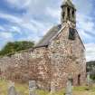
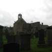
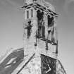
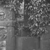
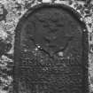
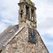
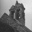
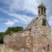
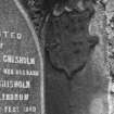
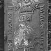
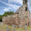
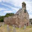
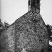
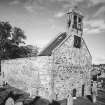
St Congan's Church was granted before AD 1214 to the Monks of Arbroath. The old parish church of St Congan was a long narrow structure, 120ft, in length, by 18ft wide. When the new church was erected in 1794 the earlier building was left to decay and the eastern end, still known as 'the quire' is all that now remains. The erection of the choir can be satisfactorily assigned to the first part of the 16th century.
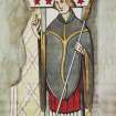
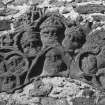
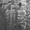
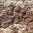
In 1861 portions of the choir were taken away, and on removing the stones from a window in the south wall which had been built up, there appeared on the splay of one side the figure of a bishop painted on the plaster in bright colours. An inscription in Gothic letters above read 'S Ninianus'. A similar painting on the other splay of the window was destroyed before it could be drawn or photographed - there is reason to believe that there was a series of similar pictures around the church.
J Stuart 1869.
This church was probably established in the 7th century by a follower of St Columba.
D MacGibbon and T Ross 1896-72.
The old parish church of Turriff still stands on the site of the church which St Congan founded. (but see NJ74NW 22 ? Monastery).
A B Scott 1918.
The remains of the old church consist of the north and south walls and the entire east gable of the choir, and measures 16.0m E-W by 7.5m transversely. The north and south walls stand to their original height of c.6m, and an interior cross wall of similar height blocks off the east half of the choir. No trace remains of the paintings mentioned by Stuart (1869).
The north and south walls are extended westwards 5.0 and 12.0m respectively by walls of a later period c.2.0m high.
Visited by OS (WDJ), 13 December 1962.
Field Visit (1 May 2011 - 1 November 2011)
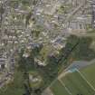
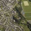
Cultural Heritage assessment for the proposed Greeness wind farm development. The assessment forms part of an Environmental Statement. The Cultural Heritage assessment identifies all historic environment features within the development area (through desk-based assessment and field survey), and key external receptors up to 10km from the proposed development. An assessment of the direct and indirect impacts of the development on these features is included.
Farmstead depicted as roofed on First Edition Ordnance Survey, now in ruins. No associated remains were discovered within the area.
Information from OASIS ID: cfaarcha1-207671 (H Tweedie) 2011
Photographic Survey (29 June 2012)
Photographed on behalf of the Buildings of Scotland publications.
Information from RCAHMS (2012).

