
Following the launch of trove.scot in February 2025 we are now planning the retiral of some of our webservices. Canmore will be switched off on 24th June 2025. Information about the closure can be found on the HES website: Retiral of HES web services | Historic Environment Scotland
Loch Cluanie, Dam


Dam (20th Century)
Site Name Loch Cluanie, Dam
Classification Dam (20th Century)
Alternative Name(s) Great Glen Hydroelectric Scheme
Canmore ID 190048
Site Number NH10NE 5
NGR NH 18465 09808
NGR Description Centred
Datum OSGB36 - NGR
Permalink http://canmore.org.uk/site/190048


- Council Highland
- Parish Urquhart And Glenmoriston
- Former Region Highland
- Former District Inverness
- Former County Inverness-shire
NH10NE 5 1845 0979
This dam spreads over onto OS 10,000 map sheet NH11SE
Information from RCAHMS (DHR), July 2001.
Field Visit (2010)
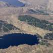
Loch Cluanie Dam is the main catchment and storage dam for the Northern section of the Great Glen scheme with water fed from a number of catchments and also fed in by tunnel from Loch Loyne (see separate item) which lies to the south. Cluanie Dam is at the top of a cascade with water passing through Ceannacroc, Livishie and Glenmorriston power stations (see separate items). The dam is rubble fill with a concrete panel fascia and oversailing vehicular access deck above fixed spillway to the centre. Tunnel gatehouse towers are located to both ends of the dam controlling flow in from Loch Loyne and flow out to Ceannacroc. A small valvehouse to the centre of the downstream face houses the compensation set and the controls for the large spiral dispersal valve. Cluanie Dam is of relatively standard design and construction. It is prominently sited adjacent to the A87 road to Kyle of Lochalsh and Skye forming a local landmark. PL Payne, 5; E Wood, 2002, 38; J Miller, 2002.
Note (25 October 2023)
The Great Glen scheme: Garry/Moriston
The garry part of the scheme uses the storage facility at Loch Quoich to supply Quoich power station via a tunnel from the dam, which is a rockfill type. Two further dams were required at the west end ofthe loch. The outflow goes vis the River Garry to Loch Garry, and eventually via a tunnel to Invergarry power station at Loch Oich. There is a dam at the east end of Loch Garry. A fish stopper and trap were built down stream of Quoich power station.
Storage for Moriston section was provided by damming Loch Loyne and Loch Cluanie, and interconnecting them by a tunnel. A second tunnel from Loch Cluanie supplies Ceannacroc power station which discharges int the River Moriston, which in turn feeds Loch Dundreggan. This loch is also fed by the outflow of Livishie power station, supplied by a system of aqueducts. Glenmoriston power station is just below the Dundreggan dam. Its outflow reaches the River Moriston at Loch Ness via a tunnel. These three power stations were built underground for environmental reasons. The control centre for the the entire scheme is at Fort Augustus. The total output capacity is 114MW. The scheme was built between 1949 and 1962.
Information from NRHE catalogue number WP007424 compiled by George Walker in 2005.

