
Brandsbutt


Stone Circle (Neolithic) - (Bronze Age)
Site Name Brandsbutt
Classification Stone Circle (Neolithic) - (Bronze Age)
Canmore ID 18882
Site Number NJ72SE 12
NGR NJ 7600 2240
Datum OSGB36 - NGR
Permalink http://canmore.org.uk/site/18882


- Council Aberdeenshire
- Parish Inverurie
- Former Region Grampian
- Former District Gordon
- Former County Aberdeenshire
NJ72SE 12 7600 2240
(NJ 7600 2239) Stone Circle (NR) (site of)
OS 1:10,000 map (1975)
Four stones of this circle still remain - two of them still in their original position and two removed. The remainder of the stones were taken either for building or agricultural purposes. When reclaiming the land on which the stones were placed, a considerable quantity of ashes of burnt wood was found, but there were no remains of any other description. One of the stones (see NJ72SE 23) is rudely sculptured but much defaced.
Name Book 1866.
Coles (1901) notes three large stones, built into the dykes on Brandsbutt farm. A circle incorporating these stones would be c. 90' in diameter. He subsequently located part of stone NJ72SE 23), built into a wall.
F R Coles 1901.
Stone 'B' and 'C' on Coles' (1901) plan are built into the southern face of a field wall, and are at NJ 7599 2241 and NJ 7600 2241 respectively. The wall at the position shown for stone 'A' has been demolished and the stone is probably one of several lying close to sculptured stone (NJ72SE 23).
'B' and 'C' surveyed at 1:2500.
Visited by OS (NKB) 10 March 1964.
This monument is situated on the crest of a shoulder of a low hill at an altitude of 90m OD. The area was under arable cultivation until 1982, being developed for residential and 'amenity' use thereafter; it is preserved as an amenity feature.
Partial excavation was carried out by I A G Shepherd and Bill Sievewright (of Ellon Plant) in January 1983; this only reached the surface of the subsoil. Careful removal of the topsoil and scraping with the ditching bucket of a Hymac revealed five stone-holes. The circle had been deliberately slighted as these stoneholes had been enlarged and refilled with topsoil, displaced packing-stones and charcoal flecks. A fragment of a standing stone lay on the subsoil surface in the NE arc and evidence of considerable burning was found adjacent to the inner face of the stone hole on the S arc. Three possible post-holes were also found between 1 and 3m outside the S arc of the circle.
(GRC air photography: AAS/83/3/S1/24 and AAS/84/14/S6/27).
NMRS, MS/712/72, visited December 1982 and January-June 1983.
Publication Account (2011)
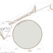
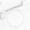
Symbols The site of this stone circle is preserved in an open space in one of the housing estates on the western outskirts of Inverurie, where its circumference is now laid out as a strip of cobbles in the grass. The stones of the circle were cleared away in the late 18th or early 19th century, but in 1866–7 four of them, including the Pictish symbol stone known as the Brandsbutt Stone, were pointed out in the adjacent field dykes to the OS surveyors, who believed that two were still in their original sockets (Name Book, Aberdeenshire, No. 42, p 5). In 1900 Coles at first located only three of the stones in the dykes, but he subsequently returned to discover the Brandsbutt Stone. He concluded that the first three were still in position, projecting a diameter a little over 27m (1901, 229–30), and it was left to Ian Shepherd to establish by excavation in 1983 that the site of the circle actually lay a little to the east. Systematically stripping back the topsoil, he located five stone-holes and estimated that in its original form the ring had measured about 25m in diameter, comprising twelve or thirteen evenly spaced orthostats (Shepherd 1983). Although Barnatt has suggested that its relatively large diameter may indicate that Bransbutt was a recumbent stone circle (1989, 273, no. 6:16), Shepherd could find no evidence of a recumbent setting, despite exposing the south-west arc of the ring. His concluding discussion favoured its interpretation as a plain circle while also entertaining the possibility that it may have had a recumbent. In the light of the present survey it is possible to make one further observation. The ground plan that Shepherd recovered is evidently slightly flattened around an east and west axis rather than circular, which by comparison with other recumbent stone circles places the most likely position for any recumbent setting on the south arc. This falls uncomfortably close to the single stone-hole he uncovered on the south side of the ring. On these grounds Brandsbutt is better considered a plain circle until proven otherwise.

