 |
On-line Digital Images |
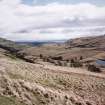
SC 579491 |
Records of the Royal Commission on the Ancient and Historical Monuments of Scotland (RCAHMS), Edinbu |
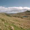
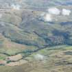
General view to south-east of Menstrie Glen from Ashentrool towards Loss.
Scan of D/59286/CN, ground view of Menstrie Glen. Scanned for Menstrie Glen publication. |
1998 |
Item Level |
|
 |
On-line Digital Images |
SC 584585 |
Records of the Royal Commission on the Ancient and Historical Monuments of Scotland (RCAHMS), Edinbu |
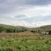
General view of Menstrie Glen from Ashentrool towards Loss. The stone dyke in the foreground is one of the new land divisions laid out in the 1760's. It marks the march between Ashentrool and Loss and the line of trees leading away on the left of the picture follows the boundary of the emparkemnt established between Loss and Townhead. |
1998 |
Item Level |
|
 |
On-line Digital Images |
SC 1440969 |
Records of the Royal Commission on the Ancient and Historical Monuments of Scotland (RCAHMS), Edinbu |
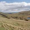
General view of Menstrie Glen from Ashentrool (NS89NW 56.00) looking south-east. |
1998 |
Item Level |
|
 |
On-line Digital Images |
DP 198028 |
RCAHMS Aerial Photography Digital |
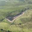
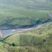
Oblique aerial view of Lossburn Reservoir at low water level, looking SSW. |
10/9/2014 |
Item Level |
|
 |
On-line Digital Images |
DP 198029 |
RCAHMS Aerial Photography Digital |
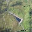
Oblique aerial view of Lossburn Reservoir at low water level, looking S. |
10/9/2014 |
Item Level |
|
 |
On-line Digital Images |
DP 198030 |
RCAHMS Aerial Photography Digital |
Oblique aerial view of Lossburn Reservoir at low water level, looking SSE. |
10/9/2014 |
Item Level |
|
 |
On-line Digital Images |
DP 222150 |
RCAHMS Aerial Photography Digital |
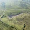
General oblique aerial view of Menstrie Glen centred on Backside of Lipney showing the recent afforestation, looking NE. |
19/9/2015 |
Item Level |
|
 |
On-line Digital Images |
DP 282108 |
Historic Environment Scotland |
Oblique aerial view. |
4/9/2018 |
Item Level |
|
 |
On-line Digital Images |
SC 2475548 |
Records of the Royal Commission on the Ancient and Historical Monuments of Scotland (RCAHMS), Edinbu |
General view of Menstrie Glen from Ashentrool (NS89NW 56.00) looking south-east. |
1998 |
Item Level |
|


