
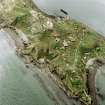
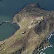
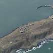
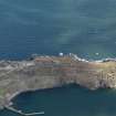
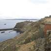
Inchkeith, Victoria Harbour, Jetty


Harbour (Period Unassigned), Jetty (Period Unassigned), Tramway (Modern)
Site Name Inchkeith, Victoria Harbour, Jetty
Classification Harbour (Period Unassigned), Jetty (Period Unassigned), Tramway (Modern)
Alternative Name(s) Firth Of Forth; Leith Harbour
Canmore ID 187337
Site Number NT28SE 12
NGR NT 29162 82668
NGR Description NT 29174 82725 to NT 29191 82619
Datum OSGB36 - NGR
Permalink http://canmore.org.uk/site/187337


- Council Fife
- Parish Kinghorn
- Former Region Fife
- Former District Kirkcaldy
- Former County Fife
NT28SE 12 29174 82725 to 29191 82619
Jetty [NAT]
Victoria Harbour [NAT]
OS 1:10,000 map, 1982.
The harbour consists of a stone built angled jetty with a secondary pier to the E. Some modifications have been undertaken since 1945. Several store houses survive around the E side of the harbour. Traces of the tramway are also found at the N end quayside.
Visited by RCAHMS (DE, AL, JM), 25 February 4th and 5th March 2009.

