
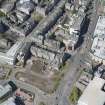
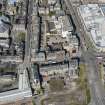
Dundee, Nethergate, General


General View (Period Unassigned)
Site Name Dundee, Nethergate, General
Classification General View (Period Unassigned)
Alternative Name(s) Whitehall Close
Canmore ID 186813
Site Number NO43SW 444
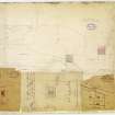
NGR NO 4010 3002
NGR Description From NO 3981 2983 to NO 4027 3019
Datum OSGB36 - NGR
Permalink http://canmore.org.uk/site/186813


- Council Dundee, City Of
- Parish Dundee (Dundee, City Of)
- Former Region Tayside
- Former District City Of Dundee
- Former County Angus
NMRS REFERENCE
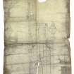
Dundee, Nethergate - Deep Sea Building
Architect: James Hutton 1893
Precise location uncertain at time of upgrade, 14.08.01
Dundee, Nethergate - Fyffe Workshops.
Architect: John Murray Robertson
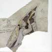
Observation (1814)
Skeletal remains found in the 19th century were regarded as victims of Monck's assault. These had been found when the buildings on the south side were cleared away early in the 19th century to widen Nethergate (here called Ladygate).
The skeletons were discovered in 1814 when houses south of church grounds were removed.
Perry, 2005
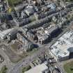
Excavation (1999)
Four human skulls, found during the reconstruction of the Overgate Centre on the north side of the City Churches in 1999, had been redeposited in a pit, and were not in situ burials.
The bones exposed were human and probably medieval. They are not cemetery burials. It is likely that they have been redeposited (ie they have been disturbed in the past and reburied) either in the Victorian period or earlier this century.
Information from Dundee SMR; Coleman, R. 1999. Medieval Burial
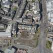
Watching Brief (4 May 2005 - 15 September 2005)
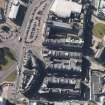
NO 4018 2990 The City of Dundee Council City Engineer's Department commissioned SUAT to undertake an archaeological watching brief on road and service works for the Dundee Central Waterfront Development. This was undertaken between 4 May and 15 September 2005. The present phase of works was largely confined within fairly recent deposits related to reclamation and demolition, and the insertion of 19th- and 20th-century services. The interesting exception was the junction of Nethergate and Marketgait, where an earlier gravel road surface may survive just 0.5m below the present road.
Report deposited with NMRS [Summarised below].
Sponsor: City of Dundee Council
David Bowler, 2006.
The area affected by these works was part of a much larger area of the Central Waterfront. The works followed Marketgait, from just N of its junction with Nethergate to its termination at the Riverside roundabout, an area consisting largely of open spaces dissected by major roads and junctions, N of Dundee Railway Station and W of Tayside House. The works consisted of re-routing the roads and all associated services, including water, drainage, electricity and gas. A particularly large and deep brick sewer running down the centre of Marketgait received new manholes. A pedestrian over bridge running N from the railway station was removed. A pedestrian underpass under Marketgait just S of Nethergate and E of Meadowside St Paul's Church was also broken out and removed.
The features and layers observed are notes in Appendices 1 and 2 [of the report]. Eighteen different contexts were recorded, which can be divided into seven brief phases.
1. A red silt… and reddish sandy gravel… seen in Nethergate, in the inland part of the site, were probably natural.
2. Adjacent gravel surfaces … may have been early road surfaces.
3. Occasional, localised patches of dark earthy rubble and stones… in the bottom of new services trenches may have been belonged to the original 18th or 19th century reclamation of this area, but no datable artefacts were found. A dark grey silty subsoil… and a stone rubble dump… may also belong to this phase.
4. Some sandstone wall foundations … were seen, perhaps from 19th century industrial buildings or tenements.
5. The most prominent features were the long red brick wall foundations … probably remains of Victorian railway platforms and buildings. Extensive spreads of red brick rubble … were probably 1960's-1970's demolition of railway structures and buildings.
6. The deep rubble dumps seen in Marketgait … were probably the fills of Victorian and modern sewer and pipe trenches, and dumps deposited to level up the gradient of the street in the 1960's-1970's. A long E-W … step in the rubble was perhaps a railway terrace, but more probably a modern (1960's-1970's) landscape feature.
8. Service ducts running along the S kerb of Nethergate were obviously modern, and still in use.
Information from SUAT, 2006

