Monymusk
Bench Mark (19th Century), Cross Slab (Pictish), Pictish Symbol Stone (Pictish)
Site Name Monymusk
Classification Bench Mark (19th Century), Cross Slab (Pictish), Pictish Symbol Stone (Pictish)
Alternative Name(s) Monymusk Castle; Monymusk Parish Church; The Monymusk Stone
Canmore ID 18658
Site Number NJ71NW 12
NGR NJ 703 151
NGR Description NJ c. 703 151 removed to 6850 1524
Datum OSGB36 - NGR
Permalink http://canmore.org.uk/site/18658
- Council Aberdeenshire
- Parish Monymusk
- Former Region Grampian
- Former District Gordon
- Former County Aberdeenshire
Monymusk 1, Aberdeenshire, Pictish symbol-bearing cross-slab
Measurements: H over 2.12m, W 0.75m
Stone type: granite
Place of discovery: NJ 703151
Present location: in Monymusk Church.
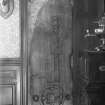
Evidence for discovery: recorded around 1800 in a field near the River Don, it was taken out and set up beside the road at NJ 7036 1478. By 1903 it had been taken to Monymusk Castle, where it was placed in a recess in the billiard room. Sometime between 1973 and 1985, it was transferred to Monymusk Church.
Present condition: good.
Description
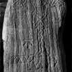
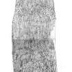
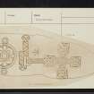
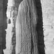
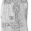
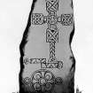
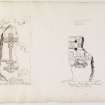
One broad face is carved in partial low relief with an ornate cross. The cross-head has equal arms with square terminals and widely rounded armpits, and a central roundel filled with eight double spirals. Each terminal contains a ring interlaced with a cross. The shaft consists of a simple two-strand plait, which expands to form the foot of the cross. Close to the foot is a step symbol, carved in partial low relief and incision, and set horizontally. Below the step is incised a triple disc symbol with a double outline, which encloses a flower-like design of circles and quatrefoils.
While the stone stood at the roadside, it was incised with an OS benchmark, adjacent to the shaft of the cross.
Date: eighth or ninth century.
References: ECMS pt 3, 192, 193-4; Fraser 2008, no 35.
Desk-based information compiled by A Ritchie 2017
NJ71NW 12 c. 703 151 removed to NJ 6850 1524
See also NJ61NE 4.00.
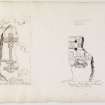
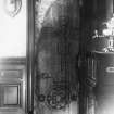
(Area: NJ 703 151). A Class II symbol stone, found about 1800 in a field near the river, was set up at NJ 7036 1478 which was the nearest point of the public road, where it is published on the 1st edition of the 6" OS map. By 1903 it had been removed to Monymusk Castle (NJ61NE 5) where it is built into an inside wall of the billiard-room and shut into a recess by an oak door. It is a pillar of granite 7' high by 2'6" wide sculptured in semi-relief on one face with an equal-armed decorated cross, with hollowed 'arm-pits', which spring from a narrow shaft. Under this is the 'step' symbol and an ornamented disc.
OS 6" map, Aberdeenshire, 1st ed., (1864-7); New Statistical Account (NSA) 1845; J R Allen and J Anderson 1903;
W D Simpson 1925.
Field Visit (25 July 1973)
As described and in good condition in House of Monymusk (formerly Monymusk Castle).
Visited by OS (ISS) 25 July 1973.
Field Visit (13 May 1991)
(Name cited as The Monymusk Stone). This stone is held in Monymusk Church (NJ61NE 4).
NMRS, MS/712/66, visited 13 May 1991.
Reference (1997)
Class II symbol stone. Below the cross are a step over a triple disc.
A Mack 1997.
Field Visit (3 July 2000)
This Class II Pictish symbol stone, which now stands in the SE corner of the tower of Monymusk Parish Church (NJ61NE 4.00) was discovered in about 1800, in a field near the River Don, where it was said to have lain from time immemorial.
A granite pillar, it measures 0.8m in width by 0.45m in thickness and 2.16m in height. It is unshaped, tapering gradually upwards to a rounded head, and is roughly triangular in section. Although striated vertically by weathering, the broad front face maintains a fairly even surface, and the carving, which cuts across the striations, is in mixture of broad, shallow, incised line, and very low relief, possibly a response to the character of the surface. Despite this, and the way that the carving follows irregularities of the stone, the quality of work is high and the lines of the design have been carefully laid out.
On the upper part of the stone there is an equal- and hollow-armed cross with a central disc. This is decorated with curvilinear ornament comprising two sets of four 'C' shaped incised lines, set out in the form of a cross-pattee. The centre and terminals of this cross each contain an incised dot. The arms of the cross are rectangular and decorated by an interlace design based upon a circle interwoven with a saltire. The interstices of the left and right arms contain pellets, as does the lower interstice of the lower arm. The intervening space between this design and the central disc is filled by a concave sided quadrangle.
The cross is set upon a narrow shaft and semi-circular base formed in a single strand interlace, though the latter does not form a true closed pattern. An Ordnance Survey benchmark is deeply cut into the surface on the left side of the shaft (viewed from in front), while below both a step symbol extends horizontally across the stone, placed off centre to curve around the left edge of the slab. The body of the symbol is decorated with diagonally placed almond-shaped motifs, and each end is embellished with a spiral-armed pelta-shaped terminal.
Below this, the lowest quarter of the stone is occupied by a centrally placed triple-disc or cauldron symbol. The small flanking rings appear to be attached to the central disc by three short lines. Each disc is depicted as two concentric circles, but the central one is also elaborately decorated. In the centre are another two concentric rings surrounding a central dot, and the intervening space is filled by arcs and short lines. The latter suggest either the petals of a flower or a curvilinear armed cross.
Although worn, the sculpture is largely intact except for an area of damage extending along the right hand side of the central boss and the lower arm. The position of the stone close to the wall prevents any examination of the back of the stone.
The area in which the stone was found is a broad expanse of arable haughland on the south side of the river. On the instructions of the then Sir Archibald Grant, it was moved to the nearest part of the public road and placed upright at the steading of Nether Mains. The stone still stood beside the road in the mid-1860s, when it was surveyed there by the Ordnance Survey (OS 6-inch map, Aberdeenshire (1st edition), sheet lxiv, 1869), and it would have been at this time that the benchmark was cut into its face. Between then and the late 1890s it was taken to Monymusk House, where it was built into a recess behind a door in the billiard room. Between 1973 and 1985 it was moved to its present position in the church.
Visited by RCAHMS (IFr, 3 July 2000)
NSA 1845; J Stuart 1856; J R Allen and J Anderson 1903.


