
Broomend Of Crichie


Cist(S) (Bronze Age), Henge (Bronze Age), Stone Circle (Bronze Age), Timber Circle (Bronze Age), Battleaxe (Bronze Age), Cinerary Urn(S) (Bronze Age)
Site Name Broomend Of Crichie
Classification Cist(S) (Bronze Age), Henge (Bronze Age), Stone Circle (Bronze Age), Timber Circle (Bronze Age), Battleaxe (Bronze Age), Cinerary Urn(S) (Bronze Age)
Alternative Name(s) 'Buckie'; Inverurie; Port Elphinstone
Canmore ID 18621
Site Number NJ71NE 6
NGR NJ 7792 1967
Datum OSGB36 - NGR
Permalink http://canmore.org.uk/site/18621


- Council Aberdeenshire
- Parish Kintore
- Former Region Grampian
- Former District Gordon
- Former County Aberdeenshire
NJ71NE 6 7792 1967
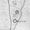
(NJ 7792 1967) Henge (NR)
OS 6" map, (1959).
For stone circles at Fullerton (NJ 7839 1797), Cairnhall (NJ 7850 1759), Hill of Tuack (NJ 7957 1544) and Castle Hill, Kintore (NJ 7939 1634), see NJ71NE 14, NJ71NE 17, NJ71NE 27 and NJ71NE 32.00, respectively.
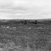
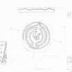
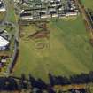
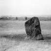
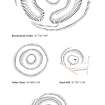
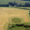
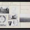
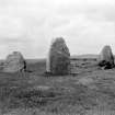
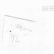
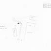
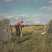
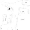
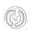
This monument consists of a flat area, diameter 50 feet, surrounded by a ditch 20 feet wide and 5 to 6 feet deep within an encircling bank also about 20 feet wide. The ditch is crossed on north and south by an earthen embankment 9 feet wide. Within the ditch there was a concentric circle of six stones, of which only two remain, at the base of each of which was found a cremation burial; one of these was accompanied by a decorated perforated stone hammer, 4 1/2 inches long and 3 1/2 inches broad, another was in a small cist, and two more were within inverted urns.
In the centre of the circle was found a deposit of burnt bones overlying a conical pit 15 feet in diameter at the top and 10 feet in diameter at the bottom, filled with small rounded stones, underneath which was a cist containing an inhumation and a cremation burial.
Two more cremation burials, one in an inverted urn, were found elsewhere in the circle. There appeared to be small animal, possibly bird, bones mixed with the various cremation deposits.
Although some authorities show a seventh stone at the centre of the circle, there is not likely to have been one there until the advent of the sculptured stone (NJ71NE 8).
C E Dalrymple 1884; F R Coles 1901; J Ritchie 1920.
The stone hammer and urns are of Late Bronze Age type.
J G D Clark 1936.
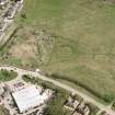
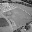
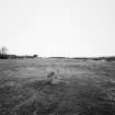
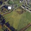
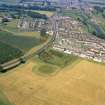
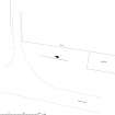
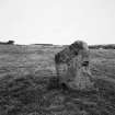
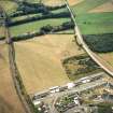
This Class II henge is situated on the S outskirts of Port Elphinstone on level ground between the main road and the railway, at a point 1/4 mile from the present position of the right bank of the River Don. Measuring 11 ft (33.5m) in diameter, it approximates very closely to the henges at Muir of Ord and Ballymeanoch.
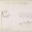
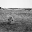
The interior contains three standing stones. Two, near the inner lip of the ditch, belong to a circular setting contemporary with the henge, but the third was erected near the centre in modern times when it was removed from a bank (50 yds to the N) which was being taken for railway ballast. Several standing stones existed in the neighbourhood of the henge, and it is only likely that this is one of them which was re-used in Early Christian times. It bears very well-preserved examples of the so-called elephant symbol, and a crescent and V-rod.
Two double crouched Beaker burials were found in two cists a few hundred yards S of the henge in 1866, one of them including the now-famous horn spoon.
R W Feachem 1963.
The henge is as described above. On the flat area are two standing stones and a sculptured stone (NJ71NE 8).
Re-surveyed at 1/2500.
Visited by OS (RD), 23 March 1964.
Battle-axe: RMS EP 2
F E S Roe 1966.
The battle-axe (NMS EP 2) is of Northern Variant grooved type, and has been petrologically identified as andalusite cordierite muscovite quartz hornfels.
T H McK Clough and W A Cummins 1988.
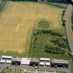
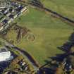
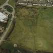
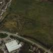
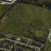
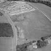
(Location cited as NJ 7792 1967). Broomend of Crichie. This henge is situated in arable ground on an undulating terrace at an altitude of 65m OD.
[Air and ground photographic imagery listed].
NMRS, MS/712/36.
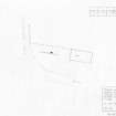
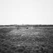
NJ 7792 1967 This was the third and final season of work at the site and took place 22 September-6 October 2007. An area of 300m2 was stripped immediately outside the S entrance to the previously excavated henge monument. It identified the position of one stone socket, which probably belonged to the southern avenue of the monument complex. Its position confirms the course of the avenue postulated by James Ritchie in the 1920s. Away from the monument were occasional postholes and a single pit, all without associated artefacts. Immediately outside the entrance and sharing the long axis of the henge monument was an almost circular setting of post pits approx 8.5m in diameter. There were no artefacts, but charcoal samples associated with the post pipes and with the weathering cones in the tops of the Archive to be deposited with RCAHMS.
Funder: Reading University, with help in kind from Aberdeenshire Council.
Richard Bradley and Amanda Clarke, 2007.
Publication Account (1986)
The now subdued circle-henge, 33.5m from crest to crest of the banks, on a gravel terrace of the River Don, just downstream from its confluence with the Urie, is only one component of what was once a late neolithic ceremonial complex of considerable importance. The principal extant monument is the henge with entrances to north and south within which are two stones, the survivors of a six-stone concentric circle. (The stone at the centre is a fme Pictish symbol stone, with beast and crescent, of c AD 600, which was placed here for safety in the 19th century.) At the base of each stone were deposits of cremated bones, in pits or cists or cordoned urns. In 1855 three separate deposits were found in front of the north-western stone: a prestigious decorated sandstone battle axe, a small circular cist and a cordoned urn. In the centre of the circle was a shaft grave more than 1.9m deep with, at the bottom, a cist containing a 'tolerably entire' skeleton and a deposit of cremated bones.
Some 50m N of the circle-henge stood a large ring, 45.7m in diameter, of three concentric circles of stones with a small cairn at their centre. The 1757 description mentions an 'altar of one stone, with a cavity in the upper part, wherein some of the blood of the sacrifice was put'. This may well have been a recumbent stone circle. It was destroyed by quarrying.
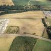
A great avenue of standing stones ran south from the destroyed site to the circle-henge and on for about 400m to a spot close to the river. The avenue has been estimated as 18.3m wide and to have contained 36 stones in each side, but only three remain, one of which can be seen just south of the henge.
In a sandbank a few metres to the west of the south end of the avenue, a small cemetery of four short cists was found in 1866. Two of the cists were larger than average and contained double burials covered with ox hides and accompanied by beakers (now in RMS). The cist cemetery and the battle axe have been interpreted as 'meaningful acts of desecration' of the old ceremonial centre by individuals or family groups who wished to demonstrate their newly acquired high status.
Information from ‘Exploring Scotland’s Heritage: Grampian’, (1986).
Publication Account (1996)
The now subd ued circle-henge, 33.5m from crest to crest of the banks, on a gravel terrace of the River Don, just downstream from its confluence with the Urie, is only one component of what was once a late neolithic ceremonial complex of considerable importance. The principal extant monument is the henge with entrances to north and south within which are two stones, the survivors of a six-stone concentric circle. (The stone at the centre is a fine Pictish symbol stone, with beast and crescent, of c AD 600, which was placed here for safety in the 19th century.) At the base of each stone were deposits of cremated bones, in pits or cists or cordoned urns. in 1855 three separate deposits were found in ftont of the northwestern stone: a prestigious decorated sandstone battle axe, a small circular cist and a cordoned urn. In the centre of the circle was a shaft grave more than 1.9m deep with, at the bottom, a cist containing a 'tolerably entire' skeleton and a deposit of cremated bones.
Some 50m N of the circle-henge stood a large ring, 45.7m in diameter, of three concentric circles of stones with a small cairn at their centre. The 1757 description mentions an 'a ltar of one stone, with a cavity in the upper part, wherein some of the blood of the sacrifice was put'. This may well have been a recumbent stone circle. It was destroyed by quarrying.
A great avenue of standing stones ran south from the destroyed site to the circle-henge and on for about 400m to a spot close to the river. The avenue has been estimated as 18.3m wide and to have contained 36 stones in each side, but only three remain, one of which can be seen just south of the henge.
In a sandbank a few metres to the west of the south end of the avenue, a small cemetery of four short cists was found in 1866. Two of the cists were larger than average and contained double burials covered with ox hides and accompanied by beakers (now in NMS). The cist cemetery and the batrle axe have been interpreted as 'meaningful acts of desecration' of the old ceremonial centre by individuals or family groups who wished to demonstrate their newly acquired high status.
Information from ‘Exploring Scotland’s Heritage: Aberdeen and North-East Scotland’, (1996).
Magnetometry (2001)
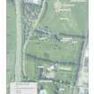
NJ 7792 1967 The henge and the rest of a field to the S of the monument (NMRS NJ71NE 6) have recently been acquired by Aberdeenshire Council; this formed the area of investigations. Two standing stones and a re-erected Pictish symbol stone are located inside the henge. A stone avenue leading into the henge was reported to have stood to the S. The stones of the avenue were broken up using gunpowder in the 19th century, although one monolith remains standing.
An area to the S of the henge, measuring 120 x 60m, was surveyed using magnetometry. A series of anomalies were recorded including the sites of possible stone holes of the avenue. The henge was surveyed using resistivity at a spacing of 25cm. No anomalies that could represent a timber or stone circle were observed.
Trench 1 (2 x 2m) was excavated on the S side of the remaining avenue monolith in order to establish the nature of its socket. The base of the stone itself appeared to be flat, and the whole monolith had been set into a relatively shallow socket. No artefacts were recovered from this trench.
Trench 2 (3 x 3m) was excavated about 30m S of the henge, around the central point of a magnetic anomaly. This proved to be a stone socket similar in nature to that recorded in Trench 1: shallow with steeply cut sides and flat-bottomed. A large piece of stone was recovered from below the turf that may be part of a broken monolith, and a retouched flint blade came from the base of the ploughsoil.
Sponsor: Historic Scotland
R Bradley, J Creighton and T Philips 2001
Excavation (22 September 2007 - 6 October 2007)
NJ 7792 1967 This was the third and final season of work at the site and took place 22 September-6 October 2007. An area of 300m2 was stripped immediately outside the S entrance to the previously excavated henge monument. It identified the position of one stone socket, which probably belonged to the southern avenue of the monument complex. Its position confirms the course of the avenue postulated by James Ritchie in the 1920s. Away from the monument were occasional postholes and a single pit, all without associated artefacts. Immediately outside the entrance and sharing the long axis of the henge monument was an almost circular setting of post pits approx 8.5m in diameter. There were no artefacts, but charcoal samples associated with the post pipes and with the weathering cones in the tops of the Archive to be deposited with RCAHMS.
Funder: Reading University, with help in kind from Aberdeenshire Council.
Richard Bradley and Amanda Clarke, 2007.
Note (February 2017)
A large and complex monument
Its story starts in the early Neolithic, when it appears the land was being used for cultivation and agriculture, likely over a continued period. Then at some point in the early Bronze Age - possibly around 4150 years ago - a henge was constructed as well as a circular stone setting. Six stones survived until 1855, when the site was first excavated, but now only three of them remain. After the construction of the henge and stone circle, the site became a place of burial. Six Bronze Age cremation burials were discovered during the original excavations placed at the base of each of the six standing stones. One of these burials included a decorated, perforated sandstone battle axe; two others were contained within inverted cordoned urns and one was positioned in a small circular cist. In addition, a collection of burnt bones was found in the middle of the stone circle, underneath which was another cist containing skeletal remains and a cremation burial. Two more cremation burials were found elsewhere in the circle: one of these was also inside an inverted urn. Interestingly, it seems that the bones of a small animal, possibly a bird, were mixed in with the various cremation deposits.
A small cemetery containing four more Bronze Age cists, this time associated with beakers, were found a few hundred yards to the south of the henge. Two of these burials were larger than normal and contained double burials. The individuals appear to have been covered with ox hides and accompanied by beakers. One contained a ladle made from the horn of an animal. In addition to the henge and stone circle, a great stone avenue once ran across the whole site, but it was broken up - by the use of gunpowder - during the 19th century. Only three of these stones survive to this day. To the north of the henge you can find three concentric circles of stones with a small cairn at the centre which may have once been a recumbent stone circle, but which was sadly destroyed during quarrying activity. In the most recent phase of excavation in 2007, an almost circular setting of wooden posts, possibly a timber circle, was discovered just outside the entrance of the henge. It appears that this site must have been considered a place of great importance for so many different monuments and burials to have been created and deposited here. It is possible that the Bronze Age burials were that of family groups or communities who were burying their loved ones here, at a place of obvious significance, to demonstrate their high status.
Continued use
However, that is not the end of the sites story. At the centre of the circle is a stone which has been carved with a Pictish symbol dating to around 600 AD. The symbol depicts a beast and a crescent. However, this stone was not placed here during the early medieval era, but was moved here for safe keeping during the 19th century. The excavators from 1855 also left their mark on the site. Buried amongst the backfill were two glass bottles – one a whisky bottle – containing some interesting finds. The excavators had carved their names and the date of the excavation (13th and the 22nd of November 1855) on to thin slivers of window glass and placed them inside. These were accompanied by a newspaper showing the train timetable from that same month.
This site, although we believe it mainly dates to the Bronze Age, beautifully demonstrates the complexities of archaeology. Sites don’t always sit in isolation, but are used and re-visited by many generations making for a wonderfully complex and diverse story.
Maya Hoole - Archaeology InSites project manager
Note (14 November 2024)
The classifications and periods of this site record have been reviewed and changed from Cist(s) (Period Unassigned); Henge (Neolithic-Bronze Age); Stone Circle (Neolithic-Bronze Age); Timber Circle (Bronze Age), Battleaxe, Cinerary Urn(s) as part of record revision work carried out by HES Designations.
Information from HES Designations (K Millican), 14 November 2024

