
Kintore


Pit(S) (Period Unassigned), Roundhouse(S) (Prehistoric), Temporary Camp (Roman)
Site Name Kintore
Classification Pit(S) (Period Unassigned), Roundhouse(S) (Prehistoric), Temporary Camp (Roman)
Alternative Name(s) Deer's Den; A96 Kintore And Blackburn By-pass; Forest Road
Canmore ID 18584
Site Number NJ71NE 28
NGR NJ 78739 16232
Datum OSGB36 - NGR
Permalink http://canmore.org.uk/site/18584


- Council Aberdeenshire
- Parish Kintore
- Former Region Grampian
- Former District Gordon
- Former County Aberdeenshire
NJ71NE 28 78739 16232
(NJ 7869 1619) Deer's Den (NAT)
Site of Supposed Camp (NR)
OS 6" map, Aberdeenshire, 1st ed., (1869)
For pits and other features discovered within and around the camp, see NJ71NE 93 and NJ71NE 127 (prehistoirc site at Deer's Den) and 140.
For length of supposed 'Roman road' (RX 18) leading NNW from the camp, see NJ71NE 153.
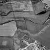
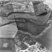
Roman camp enclosing 110 acres (44ha), first noted by Watt (1864) and planned by Capt Courtney R E (1870) after the completion of the first survey. Watt describes the bank as at least 18ft wide at base, 6ft to 8ft high, with a ditch 8ft wide, but it had already been largely destroyed when Courtney saw it; by 1934 Crawford (1949) could see no surface traces. The name of the earthwork was 'Deer's Den', and it was traditionally said to have been built to keep wild animals off the crops. The 'supposed site of Roman Road' leading from the N side was identified by another R E officer and was not confirmed by Courtney.
A Watt 1864; E H Courtney 1870; O G S Crawford 1949.
Perambulation of the area centred on NJ 7869 1619 revealed no surface indication of a camp or Roman road and no recent finds have been made in the locality. Most of the N and S sides of the camp and fragmentary stretches of the W and E sides show as crop marks on air photographs (Roman temporary camp visible on J K St Joseph air photographs D 61-3; Q 100; DE 68-71; QE 13).
Visited by OS (NKB) 16 March 1964.
120 acre camp. Severan.
J K St Joseph 1969.
The proposed second Roman temporary camp at Kintore has been excavated but the evidence found does not yet amount to proof.
Information contained in letter from J K St Joseph, 12 October 1977.
This 120-acre (Severan) camp is situated at an altitude of between 50 and 75m OD. Field investigation has revealed no surface indication of a Roman camp or road, and no recent finds have been made in the vicinity.
[Ground and air photographic imagery listed].
Information from Aberdeenshire Archaeological Service, visited 11 June 1981.
NMRS, MS/712/19 and MS/712/36.
NJ 787 166. Part of the N side was examined in 1984; the N ditch was c.3.25m wide and 1.4m deep.
About 85m to the S remains of a field-oven were located, consisting of a rectangular pit, c.1.2m by 0.9m and 0.47m deep, filled with burnt material and capped by large stones. It yielded a grain of oats.
A N Shepherd 1984; S S Frere 1988.
(Roman Camp, Kintore, Aberdeenshire: NJ 787 162). First photographed by CUCAP, 28 July 1945 (D61-3, 83). [Air photographic cover listed].
(Undated) information in NMRS, CUCAP card index catalogue.
A length of ditch of this temporary camp (including an entrance) was excavated by D Alexander (EUCFA) in 1996. The ditch and titulus were hand- and machine-excavated in places, but no Roman artifacts were discovered.
NMRS, MS/726/116.
NJ 7885 1665. During January 1996, excavation was carried out to locate and excavate a length of the perimeter ditch and a corner of the Kintore Roman temporary camp in advance of a housing development. The site was located on the NE corner of the camp, on the W edge of Kintore between the Bridgealehouse and Torry burns, due S of Bridgend farm. The area of excavations lay 50-75m E of the excavations and watching brief carried out in 1984.
Four trenches were opened:
Trench A revealed the corner of the camp. Two sections were hand-excavated through the perimeter ditch, which was cut through a fine yellow sand subsoil. Both sections measured 2.4-3.0m wide by 0.75m in depth with a U-shaped profile. The ditch contained a sequence of sandy fills. At the corner of the perimeter ditch, there were spreads of brown sandy material similar to the upper most ditch fill extending 3m both inside and outside the camp. The function of these features was unclear, although it is possible that this material comprises the upcast material from the excavation of the ditch and vestigial traces of the rampart. A sherd of green-glazed pottery was recovered during the initial cleaning of the ditch surface.
Trench B revealed a section of the perimeter ditch measuring 3.35m wide by 1.4m in depth with a V-shaped profile. As with all sections through the ditch, the fills provided evidence of an internal rampart, no traces of which survived in situ.
Within Trench C the ditch was not apparent on the surface due to the variegated sandy nature of the subsoil, and could only be clearly seen following the machine excavation of a box-section.
Within Trench D, a section was hand-excavated through the ditch and revealed a well-defined U-shaped profile, 2.95m wide by 1m in depth.
A subsequent watching brief revealed no features within the portion of the camp interior affected by the development.
Sonsor: Stewart Milne Homes.
A R Rees 1996
[No NGR cited]. An archaeological evaluation was carried out along the proposed route of the A96 Kintore Bypass in March and April 1996 through a combination of desk-based research, invasive and non-invasive fieldwork. The bypass route runs from S-N around the W side of Kintore and was known to cut across the W and S sides of the Roman temporary camp NJ71NE 28. A low-density spread of features was located within the interior of the camp, and included a field oven and a pit containing carbonised grain.
D Alexander 1996.
NJ 841 119 to NJ 784 179. A watching brief was conducted during the initial construction phase of the A96 Kintore Bypass in the spring and early summer of 1997 (see also Alexander 1996). Topsoiling activity revealed 33 archaeological features within the road corridor, the majority of which were located in the northern half of the route and concentrated immediately to the S of the Roman temporary camp. Several small concentrations of pits were located. Material retrieved from the features includes pottery, flint and burnt bone. In addition, a few isolated pits were uncovered along the length of the working swathe, none of which contained any artefacts.
A detailed report will be lodged with the NMRS.
Sponsor: The National Roads Directorate of The Scottish Office Development Department, managed on their behalf by Historic Scotland
J Hamilton and C McGill 1997
NJ 7885 1665. A programme of watching briefs was undertaken in August 1996 and November 1997 within the Scheduled area around the Roman temporary camp at Kintore (NMRS NJ71NE 28). Previous excavation on the perimeter ditch of the camp had been carried out in advance of a housing development (Rees 1996).
Small pits and a figure-of-eight oven were identified during the watching briefs. The remains of a flint core came from the oven and a flint blade came from an undefined spread. In addition, sherds of prehistoric pottery were recovered from the machined surface though no associated feature could be identified.
A report has been lodged with the NMRS.
Sponsor: Stewart Milne Homes.
B Glendinning 1998
Descheduled.
Information from Historic Scotland, Certificate of Exclusion from Schedule dated 2 November 1999.
NJ 787 158 An archaeological evaluation was undertaken on the site of a proposed housing development. Prior to the evaluation the known archaeology comprised: Deer's Den (NMRS NJ71NE 28), a Roman marching camp; a semi-circular cropmark (NMRS NJ71NE 93); and the Lands of the Holy Cross (NMRS NJ71NE 83), the possible remains of an ecclesiastical site. In addition to this, an archaeological evaluation immediately to the W of the site indicated a dense scatter of prehistoric settlement (NMRS NJ71NE 127).
The evaluation comprised the machine-excavation of c 16,200m2, representing approximately 4.6% of the total development area (35ha). In addition to this, 50 0.5m2 hand-dug test pits were excavated across the development area in order to establish the presence/absence of lithics.
The evaluation identified a variety of features ranging in date from early prehistoric to medieval/post-medieval and included: a lithic scatter; a series of Neolithic/Early Bronze Age pits; remains of later prehistoric settlement (including roundhouses and souterrains); the Roman marching camp ditch (up to 1.65m deep); a series of presumed Roman bread ovens and latrine pits; and a small group of medieval/post-medieval pits.
A programme of excavation and post-excavation is currently planned and the site archive will be lodged with the NMRS.
Sponsor: Bett Homes.
Murray Cook 2000
NJ 787 158 An archaeological excavation was undertaken between May and December 2000 prior to a proposed housing development, and followed an earlier evaluation at the development site.
Some 8.75ha was exposed, revealing features representing four broad periods of activity: early prehistoric (Neolithic and Early Bronze Age), later prehistoric (Late Bronze Age and Iron Age), Roman, and medieval/post-medieval. The excavation identified ritual and domestic features, including a flint scatter, a possible Neolithic barrow, and over 27 roundhouses including 13 ring-ditch houses. Sections of the ditch of the Roman marching camp were investigated, and over 120 ovens and a dozen latrine pits were excavated within its interior. The excavation also recovered an abundance of artefact and ecofact types, including flint tools, coarse stone, metalwork (both ferrous and non-ferrous), charcoal, ceramic, glass, slag and charred bone.
Sponsor: Bett Homes.
Murray Cook 2001.
NJ 7875 1600 An excavation was undertaken of c 1ha, prior to a proposed housing development between May and July 2002, following an earlier evaluation in March 2002.
Three broad periods of activity were represented: early prehistoric (Neolithic and Early Bronze Age), later prehistoric (Late Bronze Age and Iron Age), and Roman. The main features identified were eight Roman ovens, six roundhouses, three 4-posters, and four Neolithic pits in which structured deposition had taken place. A number of finds were recovered including flint tools, coarse stone, metalwork (ferrous and non-ferrous), ceramics, slag, charcoal and charred bone. (AOC 3787, AOC 3821)
Report to be deposited in the NMRS.
Sponsor: Malcolm Allan Housebuilders Ltd.
L Dunbar 2002.
There is no change to the existing record
Information from RCAHMS (JRS), 15 October 2003.
NJ 7869 1619 An archaeological excavation was undertaken between September 2003 and March 2004 prior to a proposed housing development at Deers Den, Kintore.
Approximately 4.65ha was exposed, producing evidence of three broad periods of activity: early prehistoric (Neolithic and Early Bronze Age); later prehistoric (Late Bronze Age and Iron Age); and Roman. The main features identified were 21 Roman ovens, four roundhouses, a possible barrow feature, and a section of the Roman marching camp ditch. The excavation also recovered a number of artefacts and ecofacts, including flint tools, metalwork (both ferrous and non-ferrous), ceramics, slag, charcoal and charred bone.
Archive to be deposited in the NMRS.
Sponsor: Stewart Milne Homes Ltd.
C Hatherley 2004
Publication Account (17 December 2011)
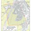
The camp at Kintore was first recorded by Captain E.H Courtney of the Royal Engineers in 1867, following receipt of a pamphlet by Mr Alexander Watt of Kintore entitled The Early History of Kintore (Watt 1865). The publication by Watt dates to 1865, but his notes about the Deer’s Den had been made some years before, probably in the 1810s (Courtney 1870: 389), although possibly slightly earlier. Courtney commented that the camp had been much reduced since Watt’s observations, noting that Watt’s measurements recorded the rampart at least 5.5m in width and up to 2.4m in height with a ditch some 3m in width. The potential accuracy of Watt’s measurements is indicated in the note that states that Watt recorded the west side as 800 yards long and Courtney as 809 yards (1870: 391n). Courtney also noted that the Aberdeenshire Canal passed through the east side of the camp (1870: 392), and this was also confirmed by excavation on the north side in 1984, indicating that it cut across the camp from northwestto south-east (Shepherd 1987: 205–6). The plan that Courtney produced of the north side, presumably derived from Watt, is fairly complete, which may suggest that Watt’s notes were made prior to the cutting of the Canal (from Aberdeen to Port Elphinstone, just south of Inverurie), which opened in 1805 and closed in 1854 (Graham 1968: 172–3). The loss of the earthworks of the camp continued, and by 1943 no trace of it could be seen on the ground (Crawford 1949: 114–15), although it has been recorded through cropmarkings since 1945.
The camp is located on the west side of the village of Kintore, on relatively flat land to the west of the River Don. The landscape covered by the camp has been under improved pasture and arable for a number of years, but this has been gradually converting to housing as Kintore has expanded, and the A96 road also cuts across it. The camp measures about 776m from NNW to SSE by about 600m transversely, enclosing 44.6ha (110 acres). Courtney did not record any gates, but entrance gaps with tituli have now been recorded in the centre of the NNW side and in the southern part of the WSW and ENE sides. The latter two have both been excavated (Alexander 2000; Dunbar & Cook 2004). There is a change of direction in the northern part of the WSW side where the camp is crossed by the road to Springburn according to Courtney’s plan (1870), and this probably represents a further entrance on that side; there is also a slight change of direction in the centre of the south side at the probable entrance gap.
The result of the expansion and development of Kintore in recent years has been a series of excavations of the majority of the camp (perimeter and interior). The widespread nature of the excavations has resulted in a wealth of material being uncovered. Over 200 features including ovens and pits have now been recorded in the interior of the camp from various excavations (Shepherd 1987; Alexander 2000; Glendinning 1998a; Hamilton & McGill 1997; Cook 2001; Cook 2002b; Dunbar 2003; Dunbar & Cook 2004; Cook & Dunbar 2008; Cook et al forthcoming). Radiocarbon dates obtained thus far indicate both Roman and post-Roman dates (Alexander 2000; Cook & Dunbar 2008), but cluster in the late 1st century ad. The first phase of the recent large-scale excavations at Forest Road has now been published (Cook & Dunbar 2008).
Excavations of the perimeter ditch have recorded that it measured up to 3.35m in width and 1.4m in depth in the north-east corner (Rees 1996), and around 3m in width and 1.5m in depth in the south-west corner (Cook & Dunbar 2008: 128–30). The site is currently unique in the Roman Empire; the wealth of internal features and finds from the camp are starting to provide valuable insights about the activities of the Roman army in the field (Cook & Dunbar 2008; Cook et al forthcoming; Cook in prep; see above, section 7f).
R H Jones.
Watching Brief (11 December 2017)
(NJ 7846 1647) A watching brief was undertaken during ground works for a dwelling house at Springburn Kintore which lies within Deers Den Roman Camp (NJ71NE0055). No archaeological features or finds were evident.
Information from OASIS ID: mas1-335120 (J C Murray) 2017
Excavation
NJ71NE 172 79118 15962
NJ 7905 1590 An evaluation was undertaken between July and November 2003 ahead of the construction of a new primary school. Overall, a 10% evaluation was conducted over three different parcels of land totalling 3.1ha. The whole of the development lies within the SW corner of the Deer's Den Roman temporary camp. The evaluation identified around 30 Roman ovens, a section of the temporary camp ditch including an entrance, and a variety of prehistoric features.
Archive to be deposited in the NMRS.
Sponsor: Aberdeenshire Council.
L Dunbar and M Cook 2003
NJ 7905 1590 Archaeological excavation between November 2003 and January 2004 followed an earlier evaluation (DES 2003, 20), ahead of the construction of a new primary school.
The excavation was zoned into 13 different areas across the site on the basis of the evaluation results. The prehistoric remains uncovered at the site included an extremely well-preserved ring-
ditch roundhouse from which a number of pottery vessels, flint artefacts and coarse stone tools were recovered. Traces of a stake-hole outer wall of this roundhouse were also recorded. A further four post-ring roundhouses and numerous pits were found across the site. A large circle of nine substantial posts has been provisionally identified as a timber circle, though as yet the feature remains undated.
The Roman remains included a section of the eastern side of the temporary camp, with entrance complete with tutulus. Over 40 Roman ovens were discovered, of which some yielded metal artefacts. Twelve pits, identified as Roman rubbish pits, were uncovered, along with a further seven sub-square pits with burning which are also thought to be of Roman date.
Archive to be deposited in the NMRS.
Sponsor: Aberdeenshire Council.
L Dunbar 2004

