
Following the launch of trove.scot in February 2025 we are now planning the retiral of some of our webservices. Canmore will be switched off on 24th June 2025. Information about the closure can be found on the HES website: Retiral of HES web services | Historic Environment Scotland
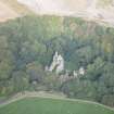
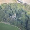
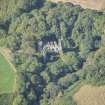
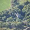
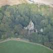
Boyne Castle


Castle (Late 16th Century)
Site Name Boyne Castle
Classification Castle (Late 16th Century)
Alternative Name(s) Boyne Water; Boyne Castle Policies; Boyn House; Bonne House
Canmore ID 18436
Site Number NJ66NW 1
NGR NJ 61155 65650
Datum OSGB36 - NGR
Permalink http://canmore.org.uk/site/18436


First 100 images shown. See the Collections panel (below) for a link to all digital images.
- Council Aberdeenshire
- Parish Boyndie
- Former Region Grampian
- Former District Banff And Buchan
- Former County Banffshire
NJ66NW 1.00 61155 65650
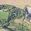
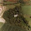
(NJ 6115 6565) Boyne Castle (NR) (In Ruins)
OS 6" map, Banffshire, 2nd ed., (1904).
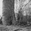
NJ66NW 1.01 NJ 61043 65626 Dovecot
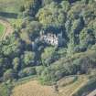
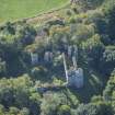
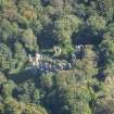
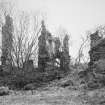
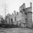
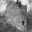
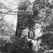
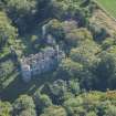
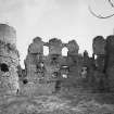
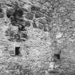
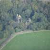
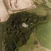
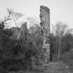
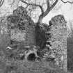
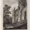
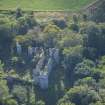
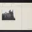
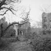
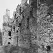
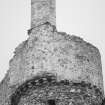
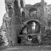
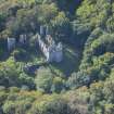
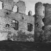
Boyne Castle is protected on three sides by the Boyne Water, and on the south side by a dry moat nearly 60ft wide.
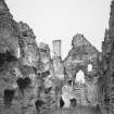
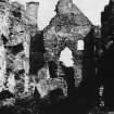
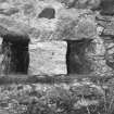
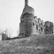
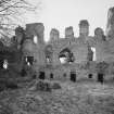
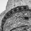
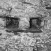
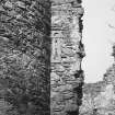
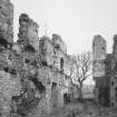
The castle is all of one design, having been built about the end of the 16th century. It consists of a courtyard forming a parallelogram with a projecting round tower 22ft in diameter at each angle. The enceinte walls average 5ft in thickness. There have been ranges of buildings on the east, west and south sides of the quadrangle, but not on the north which was enclosed by a wall. The walls of the west side are still standing but those of the south side are greatly destroyed, while the eastern range has been almost entirely demolished.
The approach to the castle from the south is through the gardens and orchards, of which some of the walls still remain. The moat is crossed by a causeway on the level of the principal entrance which is in the centre of the south front. The gateway is flanked by two cirular towers, and was no doubt protected by a drawbridge in the raised causeway.
D MacGibbon and T Ross 1887-92.
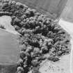
The remains of the castle are generally described by MacGibbon and Ross (1887-92). The walls of the western range of buildings and the towers still stand to a height of c.10m. The remains are in a dilapidated and ruinous condition, overgrown with vegetation.
Revised at 1/2500.
Visited by OS (WDJ) 25 September 1961.
As described above.
Visited by OS (NKB) 28 January 1968.
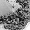
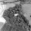
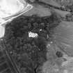
Visible on air photographs AAS/93/09/G21/6-10. Copies held by Grampian Regional Council.
Information from M Greig, Grampian Regional Council, March 1994.
Air photographs: AAS/94/17/G33/1-9.
NMRS, MS/712/21.
See catalogue for full RCAHMS Collection
Measured Survey (12 March 1990 - 16 March 1990)
Itemised under Buildings Survey Programme (DES 1990, 54).
Measured survey including a site plan at 1:500, ground and first floor plans at 1:100 and details at 1:50.
Aerial Photography (25 September 2015)
Aerial photography.

