
Stirling, 33 Spittal Street


Bank (Financial) (19th Century), Hospital (First World War), Infirmary (19th Century), Library (20th Century)
Site Name Stirling, 33 Spittal Street
Classification Bank (Financial) (19th Century), Hospital (First World War), Infirmary (19th Century), Library (20th Century)
Alternative Name(s) Commercial Bank; Stirling Infirmary; District Library; Forth Valley Health Board; Colessio Hotel
Canmore ID 181208
Site Number NS79SE 236
NGR NS 79442 93508
NGR Description Centred on NS 79442 93508
Datum OSGB36 - NGR
Permalink http://canmore.org.uk/site/181208


![Area 3B. Slots through ditch [170] facing NW](http://i.rcahms.gov.uk/canmore/l/DP00272596.jpg)
![Area 3B. Slots through ditch [170] facing SE](http://i.rcahms.gov.uk/canmore/l/DP00272598.jpg)
![Area 3B with ditch [170] in foreground, Area 3C with inter-cutting pits in the background facing NE](http://i.rcahms.gov.uk/canmore/l/DP00272599.jpg)
![Area 3C. Small group of stones within fill (181) in pit [180] facing NE](http://i.rcahms.gov.uk/canmore/l/DP00272610.jpg)
![Area 3C. Pit [172] cut by slot 174 partly excavated facing SE](http://i.rcahms.gov.uk/canmore/l/DP00272620.jpg)
![Area 3C. E-facing section of slot across pits [160] and [162], S part facing W](http://i.rcahms.gov.uk/canmore/l/DP00272635.jpg)
![Area 3C. W- facing section of slot across pits [160] and [162], S part facing E](http://i.rcahms.gov.uk/canmore/l/DP00272640.jpg)
![Area 3A. Base of well [154] facing NW](http://i.rcahms.gov.uk/canmore/l/DP00272646.jpg)
![Area 3A. Well [154] half sectioned facing NW](http://i.rcahms.gov.uk/canmore/l/DP00272653.jpg)
![Area 3C. NE facing section of slot through pit [223] facing SW](http://i.rcahms.gov.uk/canmore/l/DP00272660.jpg)

![Area 3A. Well [154] first exposed in cutting facing NW](http://i.rcahms.gov.uk/canmore/l/DP00272689.jpg)
![WB NE area. Revetment wall [247] with fill (249) in cut [248] on the right side of the wall facing SW](http://i.rcahms.gov.uk/canmore/l/DP00272700.jpg)
![WB NE area. Fill (249) in cut [248] on the right side of wall [247] facing SW](http://i.rcahms.gov.uk/canmore/l/DP00272704.jpg)
![WB NE area. NW side of wall [247] N end and wall [245] (to the right) facing SE](http://i.rcahms.gov.uk/canmore/l/DP00272718.jpg)
![WB NE area. Wall [262] in foreground. Surfaces [260] & [261] (in the background to the left). NE part of wall [264] (to the left). Deposit (267) at the base of the trench. facing NE](http://i.rcahms.gov.uk/canmore/l/DP00272737.jpg)

![WB NW area. Section across wall [302] facing NW](http://i.rcahms.gov.uk/canmore/l/DP00272768.jpg)


![Area 3B with ditch [170] in foreground, Area 3C with inter-cutting pits in the background facing NE](http://i.rcahms.gov.uk/canmore/l/DP00272594.jpg)
![Area 3A. Well [154] exposed in site edge facing NW](http://i.rcahms.gov.uk/canmore/l/DP00272605.jpg)
![Area 3A. S quadrant of well [154] excavated facing N](http://i.rcahms.gov.uk/canmore/l/DP00272627.jpg)
![Area 3C. E-facing section of slot across pits [160] and [162], N part facing W](http://i.rcahms.gov.uk/canmore/l/DP00272634.jpg)
![Area 3C. NW-facing section of slot into cut [207] facing SE](http://i.rcahms.gov.uk/canmore/l/DP00272643.jpg)
![Area 3A. Photo of monolith through the primary deposits of well [154] facing NW](http://i.rcahms.gov.uk/canmore/l/DP00272658.jpg)
![Area 3C. SW facing section of slot through pit [225] facing E](http://i.rcahms.gov.uk/canmore/l/DP00272661.jpg)
![WB NE area. Detail showing opening [246] in wall[245] facing S](http://i.rcahms.gov.uk/canmore/l/DP00272693.jpg)
![WB NE area. Cut [250] at SW corner of trench facing NW](http://i.rcahms.gov.uk/canmore/l/DP00272706.jpg)
![WB NE area. SE side of wall [247]. N of 092 facing NW](http://i.rcahms.gov.uk/canmore/l/DP00272716.jpg)
![WB NE area. SE face of revetment wall [254] partly exposed facing N](http://i.rcahms.gov.uk/canmore/l/DP00272722.jpg)
![WB NE area. Wall [245] partly removed exposing outer and inner lintel in opening [246] facing SE](http://i.rcahms.gov.uk/canmore/l/DP00272727.jpg)
![WB NE area. Wall [269] and cut [270] seen in NW side of trench facing N](http://i.rcahms.gov.uk/canmore/l/DP00272747.jpg)
![WB SW area. Cut [282] seen in NW side of trench towards the NE end facing NW](http://i.rcahms.gov.uk/canmore/l/DP00272764.jpg)
![WB NW area. Wall [302]](http://i.rcahms.gov.uk/canmore/l/DP00275235.jpg)
![WB NW area. Wall [302] partly removed, detail](http://i.rcahms.gov.uk/canmore/l/DP00275242.jpg)


![Area 3B. Ditch [170] pre-ex facing SE](http://i.rcahms.gov.uk/canmore/l/DP00272592.jpg)
![Area 3B. Slots through ditch [170] facing SE](http://i.rcahms.gov.uk/canmore/l/DP00272597.jpg)
![Area 3C. NE facing section of slot through pit [223] facing SW](http://i.rcahms.gov.uk/canmore/l/DP00272608.jpg)
![Area 3C. Slots through ditch [166] facing NE](http://i.rcahms.gov.uk/canmore/l/DP00272615.jpg)
![Area 3C. E-facing section of slot across pits [160] and [162], N part facing W](http://i.rcahms.gov.uk/canmore/l/DP00272633.jpg)
![Area 3C. W- facing section of slot across pits [160] and [162], N part facing E](http://i.rcahms.gov.uk/canmore/l/DP00272638.jpg)
![Area 3C. W- facing section of slot across pits [160] and [162], N part facing E](http://i.rcahms.gov.uk/canmore/l/DP00272639.jpg)
![Area 3A. Well [154] half sectioned, showing cut and base facing SE](http://i.rcahms.gov.uk/canmore/l/DP00272648.jpg)
![Area 3A. Well [154] half sectioned, showing cut and base facing SE](http://i.rcahms.gov.uk/canmore/l/DP00272649.jpg)
![Area 3C. SW facing section of slot through pit [225], NW end facing NE](http://i.rcahms.gov.uk/canmore/l/DP00272665.jpg)
![Area 3C. SW facing section of slot through pit [225], NW end facing NE](http://i.rcahms.gov.uk/canmore/l/DP00272666.jpg)
![Area 3C. Segment of cross section of pit [225] facing N](http://i.rcahms.gov.uk/canmore/l/DP00272674.jpg)
![Area 3C. Slots through pits [223] and [225] facing N](http://i.rcahms.gov.uk/canmore/l/DP00272675.jpg)
![WB NE area. Revetment wall [247] leading up to N corner of building (Wall [245]) facing SW](http://i.rcahms.gov.uk/canmore/l/DP00272697.jpg)
![WB NE area. Revetment wall [247] leading up to N corner of building (Wall [245]) facing S](http://i.rcahms.gov.uk/canmore/l/DP00272701.jpg)
![WB NE area. SE side of wall [247]. N of 091 facing NW](http://i.rcahms.gov.uk/canmore/l/DP00272715.jpg)
![WB NE area. Working shot. View towards wall [262] and floor surface [261] facing SW](http://i.rcahms.gov.uk/canmore/l/DP00272731.jpg)
![WB NE area. Wall [263] in the foreground. Floor [261] in the background facing NE](http://i.rcahms.gov.uk/canmore/l/DP00272736.jpg)
![WB NE area. SW side of wall [262] exposed under mortared surface [260] facing NE](http://i.rcahms.gov.uk/canmore/l/DP00272742.jpg)
![WB SW area. W side of wall [272] exposed in trench to the SE facing SE](http://i.rcahms.gov.uk/canmore/l/DP00272754.jpg)
![WB SW area. E side of wall [272] exposed in trench to the SE facing NW](http://i.rcahms.gov.uk/canmore/l/DP00272757.jpg)
![WB SW area. Top of wall [272] exposed in trench to the SE facing SW](http://i.rcahms.gov.uk/canmore/l/DP00272758.jpg)

![WB NW area. Wall [302] from above](http://i.rcahms.gov.uk/canmore/l/DP00275234.jpg)


![Area 3B. Slots through ditch [170] facing NW](http://i.rcahms.gov.uk/canmore/s/DP00272596.jpg)
![Area 3B. Slots through ditch [170] facing SE](http://i.rcahms.gov.uk/canmore/s/DP00272598.jpg)
![Area 3B with ditch [170] in foreground, Area 3C with inter-cutting pits in the background facing NE](http://i.rcahms.gov.uk/canmore/s/DP00272599.jpg)
![Area 3C. Small group of stones within fill (181) in pit [180] facing NE](http://i.rcahms.gov.uk/canmore/s/DP00272610.jpg)
![Area 3C. Pit [172] cut by slot 174 partly excavated facing SE](http://i.rcahms.gov.uk/canmore/s/DP00272620.jpg)
![Area 3C. E-facing section of slot across pits [160] and [162], S part facing W](http://i.rcahms.gov.uk/canmore/s/DP00272635.jpg)
![Area 3C. W- facing section of slot across pits [160] and [162], S part facing E](http://i.rcahms.gov.uk/canmore/s/DP00272640.jpg)
![Area 3A. Base of well [154] facing NW](http://i.rcahms.gov.uk/canmore/s/DP00272646.jpg)
![Area 3A. Well [154] half sectioned facing NW](http://i.rcahms.gov.uk/canmore/s/DP00272653.jpg)
![Area 3C. NE facing section of slot through pit [223] facing SW](http://i.rcahms.gov.uk/canmore/s/DP00272660.jpg)

![Area 3A. Well [154] first exposed in cutting facing NW](http://i.rcahms.gov.uk/canmore/s/DP00272689.jpg)
![WB NE area. Revetment wall [247] with fill (249) in cut [248] on the right side of the wall facing SW](http://i.rcahms.gov.uk/canmore/s/DP00272700.jpg)
![WB NE area. Fill (249) in cut [248] on the right side of wall [247] facing SW](http://i.rcahms.gov.uk/canmore/s/DP00272704.jpg)
![WB NE area. NW side of wall [247] N end and wall [245] (to the right) facing SE](http://i.rcahms.gov.uk/canmore/s/DP00272718.jpg)
![WB NE area. Wall [262] in foreground. Surfaces [260] & [261] (in the background to the left). NE part of wall [264] (to the left). Deposit (267) at the base of the trench. facing NE](http://i.rcahms.gov.uk/canmore/s/DP00272737.jpg)

![WB NW area. Section across wall [302] facing NW](http://i.rcahms.gov.uk/canmore/s/DP00272768.jpg)


![Area 3B with ditch [170] in foreground, Area 3C with inter-cutting pits in the background facing NE](http://i.rcahms.gov.uk/canmore/s/DP00272594.jpg)
![Area 3A. Well [154] exposed in site edge facing NW](http://i.rcahms.gov.uk/canmore/s/DP00272605.jpg)
![Area 3A. S quadrant of well [154] excavated facing N](http://i.rcahms.gov.uk/canmore/s/DP00272627.jpg)
![Area 3C. E-facing section of slot across pits [160] and [162], N part facing W](http://i.rcahms.gov.uk/canmore/s/DP00272634.jpg)
![Area 3C. NW-facing section of slot into cut [207] facing SE](http://i.rcahms.gov.uk/canmore/s/DP00272643.jpg)
![Area 3A. Photo of monolith through the primary deposits of well [154] facing NW](http://i.rcahms.gov.uk/canmore/s/DP00272658.jpg)
![Area 3C. SW facing section of slot through pit [225] facing E](http://i.rcahms.gov.uk/canmore/s/DP00272661.jpg)
![WB NE area. Detail showing opening [246] in wall[245] facing S](http://i.rcahms.gov.uk/canmore/s/DP00272693.jpg)
![WB NE area. Cut [250] at SW corner of trench facing NW](http://i.rcahms.gov.uk/canmore/s/DP00272706.jpg)
![WB NE area. SE side of wall [247]. N of 092 facing NW](http://i.rcahms.gov.uk/canmore/s/DP00272716.jpg)
![WB NE area. SE face of revetment wall [254] partly exposed facing N](http://i.rcahms.gov.uk/canmore/s/DP00272722.jpg)
![WB NE area. Wall [245] partly removed exposing outer and inner lintel in opening [246] facing SE](http://i.rcahms.gov.uk/canmore/s/DP00272727.jpg)
![WB NE area. Wall [269] and cut [270] seen in NW side of trench facing N](http://i.rcahms.gov.uk/canmore/s/DP00272747.jpg)
![WB SW area. Cut [282] seen in NW side of trench towards the NE end facing NW](http://i.rcahms.gov.uk/canmore/s/DP00272764.jpg)
![WB NW area. Wall [302]](http://i.rcahms.gov.uk/canmore/s/DP00275235.jpg)
![WB NW area. Wall [302] partly removed, detail](http://i.rcahms.gov.uk/canmore/s/DP00275242.jpg)


![Area 3B. Ditch [170] pre-ex facing SE](http://i.rcahms.gov.uk/canmore/s/DP00272592.jpg)
![Area 3B. Slots through ditch [170] facing SE](http://i.rcahms.gov.uk/canmore/s/DP00272597.jpg)
![Area 3C. NE facing section of slot through pit [223] facing SW](http://i.rcahms.gov.uk/canmore/s/DP00272608.jpg)
![Area 3C. Slots through ditch [166] facing NE](http://i.rcahms.gov.uk/canmore/s/DP00272615.jpg)
![Area 3C. E-facing section of slot across pits [160] and [162], N part facing W](http://i.rcahms.gov.uk/canmore/s/DP00272633.jpg)
![Area 3C. W- facing section of slot across pits [160] and [162], N part facing E](http://i.rcahms.gov.uk/canmore/s/DP00272638.jpg)
![Area 3C. W- facing section of slot across pits [160] and [162], N part facing E](http://i.rcahms.gov.uk/canmore/s/DP00272639.jpg)
![Area 3A. Well [154] half sectioned, showing cut and base facing SE](http://i.rcahms.gov.uk/canmore/s/DP00272648.jpg)
![Area 3A. Well [154] half sectioned, showing cut and base facing SE](http://i.rcahms.gov.uk/canmore/s/DP00272649.jpg)
![Area 3C. SW facing section of slot through pit [225], NW end facing NE](http://i.rcahms.gov.uk/canmore/s/DP00272665.jpg)
![Area 3C. SW facing section of slot through pit [225], NW end facing NE](http://i.rcahms.gov.uk/canmore/s/DP00272666.jpg)
![Area 3C. Segment of cross section of pit [225] facing N](http://i.rcahms.gov.uk/canmore/s/DP00272674.jpg)
![Area 3C. Slots through pits [223] and [225] facing N](http://i.rcahms.gov.uk/canmore/s/DP00272675.jpg)
![WB NE area. Revetment wall [247] leading up to N corner of building (Wall [245]) facing SW](http://i.rcahms.gov.uk/canmore/s/DP00272697.jpg)
![WB NE area. Revetment wall [247] leading up to N corner of building (Wall [245]) facing S](http://i.rcahms.gov.uk/canmore/s/DP00272701.jpg)
![WB NE area. SE side of wall [247]. N of 091 facing NW](http://i.rcahms.gov.uk/canmore/s/DP00272715.jpg)
![WB NE area. Working shot. View towards wall [262] and floor surface [261] facing SW](http://i.rcahms.gov.uk/canmore/s/DP00272731.jpg)
![WB NE area. Wall [263] in the foreground. Floor [261] in the background facing NE](http://i.rcahms.gov.uk/canmore/s/DP00272736.jpg)
![WB NE area. SW side of wall [262] exposed under mortared surface [260] facing NE](http://i.rcahms.gov.uk/canmore/s/DP00272742.jpg)
![WB SW area. W side of wall [272] exposed in trench to the SE facing SE](http://i.rcahms.gov.uk/canmore/s/DP00272754.jpg)
![WB SW area. E side of wall [272] exposed in trench to the SE facing NW](http://i.rcahms.gov.uk/canmore/s/DP00272757.jpg)
![WB SW area. Top of wall [272] exposed in trench to the SE facing SW](http://i.rcahms.gov.uk/canmore/s/DP00272758.jpg)

![WB NW area. Wall [302] from above](http://i.rcahms.gov.uk/canmore/s/DP00275234.jpg)


First 100 images shown. See the Collections panel (below) for a link to all digital images.
- Council Stirling
- Parish Stirling
- Former Region Central
- Former District Stirling
- Former County Stirlingshire
NS79SE 236 79442, 93508
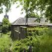
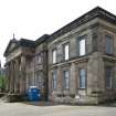
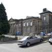
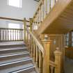
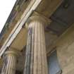
33 Spittal Street, originally built 1825-27 as the Commercial Bank, designed by James Gillespie Graham. Classical 5-bay street elevation dominated by Doric columned portico. Converted to use as the first Stirling Infirmary by Peddie & Kinnear 1873-74, and subsequently enlarged in 1878, 1883 and 1913. Superceded by a new Infirmary in 1928, and later used as a district library and offices for the Forth Valley Health Board.
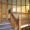
Visited by RCAHMS in June 2009 prior to conversion to a hotel. Interiors are much altered from both the original layout and the early 20th century incarnation of the building.
NMRS REFERENCE:
Plans; Dick Peddie & MacKay, Edinburgh alterations
Bin 7, Bag 2 Peddie and Kinnear 1873
NMRS MISCELLANEOUS:
Bedford Lemere Register, London No.829940 - negatives
Photographic Survey (3 June 2009)
This site was recorded by RCAHMS Threatened Buildings Survey prior to work commencing on the building's conversion to a hotel.
Excavation (2 October 2009 - 14 January 2014)
NS 7943 9349 A monitoring programme was intermittently carried out, 2 October 2009 – 14 January 2014, during ground-breaking works associated with the conversion of a 19th-century building into a hotel. The work included watching briefs during the excavation of test pits and service trenches and a small open-area excavation. The fieldwork uncovered boundaries, a well and large pits associated with activity within the medieval burgage plots stretching back from Spittal Street. The features produced large amounts of pot dating from the 12th to 16th century. No medieval buildings were recorded. Remains of post-medieval buildings and boundaries in the form of mortared stone walls were recorded at several locations. Some of these can be identified as a building and walls featured on the 1st Edition OS map from the mid-19th century.
Archive: NRHE
Funder: Colessio Hotel Ltd
Magnar Dalland and Edward Bailey – Headland Archaeology Ltd
(Source: DES, Volume 17)
Project (March 2013 - September 2013)
A project to characterise the quantity and quality of the Scottish resource of known surviving remains of the First World War. Carried out in partnership between Historic Scotland and RCAHMS.

