
Pricing Change
New pricing for orders of material from this site will come into place shortly. Charges for supply of digital images, digitisation on demand, prints and licensing will be altered.
Tillyfourie


Recumbent Stone Circle (Neolithic) - (Bronze Age)
Site Name Tillyfourie
Classification Recumbent Stone Circle (Neolithic) - (Bronze Age)
Alternative Name(s) Tillyfaune Hill; Tillyfourie Hill; Whitehill, Bogmore Wood; Whitehill Wood
Canmore ID 18074
Site Number NJ61SW 3
NGR NJ 6431 1350
Datum OSGB36 - NGR
Permalink http://canmore.org.uk/site/18074


- Council Aberdeenshire
- Parish Monymusk
- Former Region Grampian
- Former District Gordon
- Former County Aberdeenshire
NJ61SW 3 6431 1350
See also NJ71NW 15.
Not to be confused with the similar monument at Carnousie House Policies (NJ65SE 12), to which the name 'Whitehill Wood' has also been applied.
(NJ 6431 1350) Stone Circle (NR)
OS 6" map, (1959)
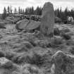
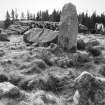
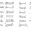
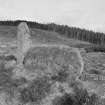
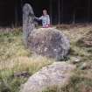
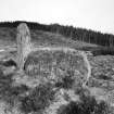
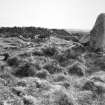
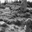
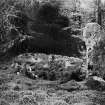
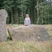
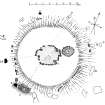
A Recumbent Stone Circle. The outer circle was approximately 60 feet in diameter. Only the recumbent stone, its W flanking pillar, and two other stones are in situ, though a number of prostrate stones remain. Within this there has been a circular mound of small stones about 15 feet in breadth, according to Stuart (1855) in 1853, with an outer kerb formed of large slabs set end to end, inclosing a central open space, 9 feet in diameter, free of stones of any kind.
Coles (1901), in 1900, found this mound extensively disturbed and reduced to a flat, level 'rampart' c. 12ft broad rising in some places above the height of the recumbent stone, but lying within the remain of its kerb.
The disturbance at the centre of this mound had revealed a central setting of stones enclosing an area 16ft and 13 1/2 ft across. East of this was a small circular pit of boulders.
Stuart noted the remains of a dyke 'running from a stone on the NW in a N direction about 100 yards - then turning W about 15 or 20 yards, it arrives at a small cairn or circle with some flat stones round its outer base. From this the dyke runs to the south, and afterwards to the east, on which side it appears to rejoin the circle almost oppoosite to its centre. There are also vestiges of a dyke striking off to the east; and on this moor, as well as on another separated from the first by a slight ravine, are a large number of small tumuli.'
J Stuart 1855; F R Coles 1901.
Keiller (1934) mentions the finding of a prostrate stone 6ft in length, east of and at a point 34ft below the level of this circle but does
not consider it an outlier of the circle.
A Keiller 1934.
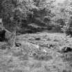
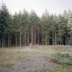
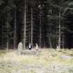
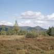
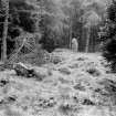
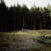
A recumbent stone circle as described and illustrated by Coles (1901) situated in a clearing in a dense young forest which encroaches onto the circle. The 'dykes' running from the circle, the 'small cairn or circle' and the 'large number of tumuli' were not seen; these have almost certainly been destroyed by the afforestation.
Re-surveyed at 1/2500.
Visited by OS (NKB) 7 February 1968.
(Name cited as Whitehill, Bogmore Wood).
NMRS, MS/712/57.
The recumbent stone circle described by the OS (NJ71NW 15) at Whitehill refers to this site.
Information from RCAHMS (ATW), 23 February 2005.
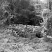
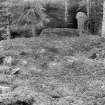
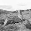
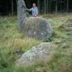
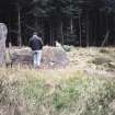
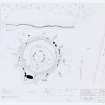
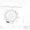
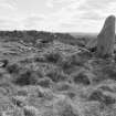
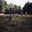
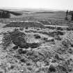
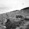
Field Visit (11 May 1998 - 12 May 1998)
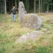
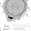
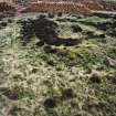
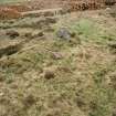
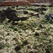
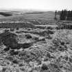
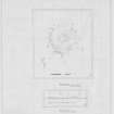
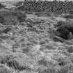
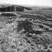
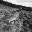
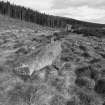
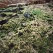
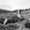
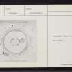
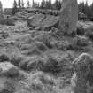
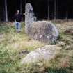
At the time of the survey in 1998, this recumbent stone circle stood in a heather- and grass-grown clearing beside a track in Bogmore Wood. Since then the surrounding forest has been felled, revealing its topographical position on a terrace on the SE slopes of White Lady. Of its thirteen stones, only the recumbent (2), the west flanker (1) and one orthostat (10) are still upright, but the circle is otherwise substantially complete, measuring about 20m in diameter and enclosing a well-defined ring-cairn. The recumbent boulder (2), which lies on the SSW, measures about 2.85m in length by 1.45m in height and is placed at a skewed angle to face almost S. Its horizontal summit is relatively even and a substantial earthfast stone behind its W end appears to chock it in position and prevent it from tumbling backwards. The W flanker (1) is a relatively slender pillar standing 2.3m high and arches over the end of the recumbent, but the E flanker (2), a broader slab, has fallen forwards, exposing its full length of 2.6m. When erect the two stones would have been of similar heights, and to a certain extent the curve of the eastern edge of the E flanker may have created the allusion of the pronounced inward curve of its neighbour on the W. Like the W flanker it was probably set back from the front of the recumbent and turned slightly to trace the arc of the circle. Apart from the one orthostat surviving upright on the NNW and two others leaning steeply on the E arc, six of the other seven are prostrate (4, 5, 8, 9, 12 & 13) and the seventh (11) has been broken up into at least four pieces which lie discarded on the NW. Under these circumstances it is difficult to demonstrate that the heights of the stones were graded, but in general the smaller stones are on the N and the lengths of the fallen and leaning stones around the E suggest that on this side at least their tops progressively reduced in height from S to N; on the W, however, where the circle climbs a low scarp that tilts the W half of the monument towards the E, they almost certainly did not. The internal ring-cairn measures about 17m across, rising from the top of the surrounding kerb to a flat top 14m in diameter and 0.6m in maximum height. The rubble-choked court at its centre is about 4.5m in diameter and the sixteen remaining stones of the inner kerb increase in height from N to S. The outer kerb, which evidently turned outwards to meet the back of the recumbent setting on the SSW, is not so clearly graded, but the largest of the 32 earthfast and fallen kerbstones that are visible is set immediately behind the W flanker.
Visited by RCAHMS (ATW and KHJM) 11-12 May 1998

