
Pricing Change
New pricing for orders of material from this site will come into place shortly. Charges for supply of digital images, digitisation on demand, prints and licensing will be altered.
Point Of Buckquoy


Settlement (Period Unassigned)
Site Name Point Of Buckquoy
Classification Settlement (Period Unassigned)
Canmore ID 1800
Site Number HY22NW 12
NGR HY 2428 2839
Datum OSGB36 - NGR
Permalink http://canmore.org.uk/site/1800


- Council Orkney Islands
- Parish Birsay And Harray
- Former Region Orkney Islands Area
- Former District Orkney
- Former County Orkney
HY22NW 12.00 2428 2839
HY22NW 12.01 HY 2428 2839 Roman pottery; Glass; Clay pipe
HY22NW 12.02 HY 2429 2840 Building (Possible); Midden
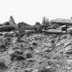
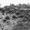
(HY 2428 2837) A possible Iron Age settlement, of which six or seven huts remain, was excavated by Wainwright at the Point of Buckquoy in 1960.
The excavations revealed the remains of two stone-built huts in
sections 'A' and 'B', of which half of one had been eroded by the sea (the greatest dimension of the remains of this one was about 14ft). The lowest course of the walls was a row of upright stones. A circular hearth, about 4ft in diameter and edged with a kerb of upright stones 6 to 7ins high, was found in section 'C': its relationship to the huts is not clear.
The huts were built with a common wall, as at Skara Brae (HY21NW 12), in the core of which were found animal bones, etc., and were probably erected on the surface of the ground rather than partly buried: windblown sand had piled up on the outside, and also inside the huts, where it preceeded the collapse of the huts. The debris within the eroded hut, and its corbelled walls, suggested that the roof was of stone slabs and that the hut was beehive-shaped.
Finds, none of which were datable, included hundreds of shells and much animal, fish and bird bone: their distribution showed that the site was also occupied before the construction and after the collapse of the huts.
The excavations were subsequently filled in.
Information taken from Orkney Survey of 1969 (Wainwrights MS notes etc now in the possession of RCAHMS).
The excavations are filled in but fragments of walling of hut 'B' and midden material are visible in the ground and the cliff edge.
Surveyed at 1:2500.
Visited by OS(ISS) 24 May 1973.
Excavations in 1980 revealed the structures excavated by Wainwright and it was possible to make a stratigraphic link between these structures (phase D) and a deposit of midden material (phase C) which could be seen in the cliff face on the S side of the Point of Buckquoy. It seems likely that the structures excavated by Wainwright had been constructed by forming a low bank, partially composed of midden material, against which the wall stones were pressed. In consequence of the construction of this bank, a shallow ditch, cut into the earlier midden deposit, was formed following the approximate line of the curving wall. The destruction of an earlier phase of building was found beneath the midden (phase B) but this was not excavated in 1980. Samples of mammal bone recovered by Wainwright from the midden gave a radiocarbon date of 3895+/- 75 bp (GU-1557); further finds are in Tankerness House Museum, Kirkwall; biological material in RMS, Edinburgh.
C D Morris (VESARP) 1989
Excavation (1960)
(HY 2428 2837) A possible Iron Age settlement, of which six or seven huts remain, was excavated by Wainwright at the Point of Buckquoy in 1960.
The excavations revealed the remains of two stone-built huts in
sections 'A' and 'B', of which half of one had been eroded by the sea (the greatest dimension of the remains of this one was about 14ft). The lowest course of the walls was a row of upright stones. A circular hearth, about 4ft in diameter and edged with a kerb of upright stones 6 to 7ins high, was found in section 'C': its relationship to the huts is not clear.
The huts were built with a common wall, as at Skara Brae (HY21NW 12), in the core of which were found animal bones, etc., and were probably erected on the surface of the ground rather than partly buried: windblown sand had piled up on the outside, and also inside the huts, where it preceeded the collapse of the huts. The debris within the eroded hut, and its corbelled walls, suggested that the roof was of stone slabs and that the hut was beehive-shaped.
Finds, none of which were datable, included hundreds of shells and much animal, fish and bird bone: their distribution showed that the site was also occupied before the construction and after the collapse of the huts.
The excavations were subsequently filled in.
Information taken from Orkney Survey of 1969 (Wainwrights MS notes etc now in the possession of RCAHMS).
Field Visit (24 May 1973)
The excavations are filled in but fragments of walling of hut 'B' and midden material are visible in the ground and the cliff edge.
Surveyed at 1:2500.
Visited by OS(ISS) 24 May 1973.

