|
Prints and Drawings |
RCD 31/1 |
|
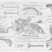
Mechanical copy of drawing showing plans and dimensions of Harbours, Wharfs and Ferry-Piers.
Kirkwall Harbour, Fortrose Harbour, Cullen Harbour, Avoch Harbour, Peterhead Harbour, Portmaholmach Harbour, Channery Point-Ferry Pier, Ballintraed Harbour, Nairn Harbour, Gordoun Harbour, Burgh-head Harbour, Fraserburgh Harbour, Invergordon Ferry Piers, Dingwall Canal, Bamff Harbour, Inverfarigaig Landing-pier, St. Catherines Ferry Pier, Portree Harbour, Corran of Ardgower Pier(West side), East Tarbert Harbour, Kyle Haken S.W. Ferry Pier, Corran of Ardgower Ferry Pier (East side), Feoline Harbour, Kyle Haken N.E. Ferry Pier, Tobermory Harbour, Kyle Rhea Ferry Pier (North side), Small Isles Harbour, Kyle Rhea Fery Pier (South side), Pier for Dornie Ferry.
Titled: 'Plans And Dimensions Of Harbours, Wharfs And Ferry-Piers, Made Or Improved Under
The Direction Of The Commissioners For Highland Roads And Bridges, 1806-1821. Thos. Telford,
Engineer.' |
1806 |
Item Level |
|
|
Photographs and Off-line Digital Images |
B 92093 PO |
Records of Aberdeen Aerial Surveys, Aberdeen, Scotland |
Aerial view. |
1985 |
Item Level |
|
|
Photographs and Off-line Digital Images |
C 26622 |
RCAHMS Aerial Photography |
Oblique aerial view. |
1994 |
Item Level |
|
|
Photographs and Off-line Digital Images |
C 26623 |
RCAHMS Aerial Photography |
Aerial view. |
1994 |
Item Level |
|
|
Manuscripts |
MS 712/29 |
Records of Aberdeenshire Archaeology Service, Aberdeen, Scotland |
(Bound typescript A4) catalogue of photographs from Aberdeenshire Archaeological Service (formerly Grampian Regional Council) aerial reconnaissance, 1997. (Includes sites and monuments in Angus). |
1997 |
Item Level |
|
 |
On-line Digital Images |
SC 396848 |
RCAHMS Aerial Photography |
Oblique aerial view. Cropped. |
1994 |
Item Level |
|
|
Photographs and Off-line Digital Images |
RCD 31/1 P |
|
Photographic copy of drawing showing plans and dimensions of Harbours, Wharfs and Ferry-Piers.
|
1806 |
Item Level |
|
|
Photographs and Off-line Digital Images |
BN 691 |
|
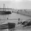
View of Cullen harbour wall from SW. |
c. 1890 |
Item Level |
|
|
Print Room |
B 41885 |
|
Historic photograph.
General view from N. |
|
Item Level |
|
|
Photographs and Off-line Digital Images |
BN 1196 |
|
General view from S. |
1973 |
Item Level |
|
|
Photographs and Off-line Digital Images |
BN 1195 |
|
Detail of capstan on N pier. |
1973 |
Item Level |
|
|
All Other |
BNR 10/1 |
|
Record sheet. |
7/1973 |
Item Level |
|
|
Manuscripts |
B 6067 |
|
Detail of capstan on N wall of harbour. |
1/6/1983 |
Item Level |
|
|
Manuscripts |
B 6068 |
|
Detail of top of capstan on N wall of harbour. |
1/6/1983 |
Item Level |
|
|
Photographs and Off-line Digital Images |
A 3602 |
Collection of photographic copies of postcards of Cullen, Moray, Scotland |
General view. |
|
Item Level |
|
|
Photographs and Off-line Digital Images |
A 3606 |
Collection of photographic copies of postcards of Cullen, Moray, Scotland |
General view. |
|
Item Level |
|
 |
On-line Digital Images |
DP 018083 |
General Collection |
Engraving of elevation and plan inscr: ''Plans and Dimensions of Harbours, Wharfs and Ferry-Piers made or improved under the direction of the Commissioner for Highland Roads and Bridges, 1806-1821.'' |
1838 |
Item Level |
|
 |
On-line Digital Images |
DP 019349 |
RCAHMS Aerial Photography Digital |
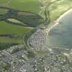
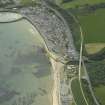
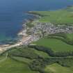
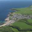
General oblique aerial view of the village centred on the harbour and the railway viaduct, taken from the E. |
7/7/2006 |
Item Level |
|
 |
On-line Digital Images |
DP 019350 |
RCAHMS Aerial Photography Digital |
General oblique aerial view of the village centred on the harbour and the railway viaduct, taken from the NNE. |
7/7/2006 |
Item Level |
|
 |
On-line Digital Images |
DP 019351 |
RCAHMS Aerial Photography Digital |
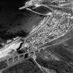
Oblique aerial view centred on the railway viaduct and road bridge with the harbour and village adjacent, taken from the WNW. |
7/7/2006 |
Item Level |
|
 |
On-line Digital Images |
SC 1160029 |
|
View of Cullen harbour wall from SW. |
c. 1890 |
Item Level |
|
|
Print Room |
PA 139/4 |
General Collection. Photograph Albums. |
View of town and viaduct from the harbour, Seatown, Cullen. |
c. 1900 |
Item Level |
|
 |
On-line Digital Images |
DP 075574 |
RCAHMS Aerial Photography Digital |
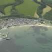
General oblique aerial view centred on the town of Cullen, taken from the WSW. |
30/5/2009 |
Item Level |
|
 |
On-line Digital Images |
DP 075575 |
RCAHMS Aerial Photography Digital |
General oblique aerial view centred on the town of Cullen, taken from the WSW. |
30/5/2009 |
Item Level |
|


