
Cullen, Castle Hill


Motte (Medieval)
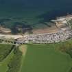
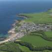
Site Name Cullen, Castle Hill
Classification Motte (Medieval)
Canmore ID 17943
Site Number NJ56NW 10
NGR NJ 5087 6702
Datum OSGB36 - NGR
Permalink http://canmore.org.uk/site/17943


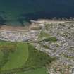

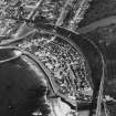

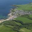
- Council Moray
- Parish Cullen
- Former Region Grampian
- Former District Moray
- Former County Banffshire
NJ56NW 10 5087 6702.
(NJ 5087 6702 ) Castle (NR) (Site of)
OS 6" map, (1959)
Slight remains of masonry suggest a similarity between the castle of Cullen and those of Kinedard and Elgin, both of which were occupied in 1296.
A Jervise 1873.
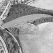
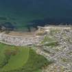
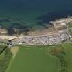
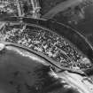
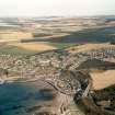
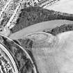
Castle Hill, according to Dr Simpson (information from Dr W D Simpson, Kings College Library, Aberdeen) is a motte, encircled by a wide ditch and outer rampart, save in the N side where it is destroyed by landslip. The ditch is generally 6.0m wide and 1.7m deep; the outer bank is about 6.0m wide and 1.5m high.
The hill is mutilated by paths, benches, and on the summit by an ornamental cross-base (See NJ56NW 9).
Revised at 1/2500.
Visited by OS (NKB) 14 August 1967.
Reference (1873)
Slight remains of masonry suggest a similarity between the castle of Cullen and those of Kinedard and Elgin, both of which were occupied in 1296.
A Jervise 1873.
Field Visit (14 August 1967)
Castle Hill, according to Dr Simpson (information from Dr W D Simpson, Kings College Library, Aberdeen) is a motte, encircled by a wide ditch and outer rampart, save in the N side where it is destroyed by landslip. The ditch is generally 6.0m wide and 1.7m deep; the outer bank is about 6.0m wide and 1.5m high.
The hill is mutilated by paths, benches, and on the summit by an ornamental cross-base (See NJ56NW 9).
Revised at 1/2500.
Visited by OS (NKB) 14 August 1967.
Excavation (February 2017 - October 2017)
NJ 50880 67024 A programme of archaeological work was undertaken, February–October 2017, as part of a community led programme to restore and enhance a network of antiquarian paths on and around a medieval motte, with the aim of improving public access and minimising erosion. Scheduled monument consent was given for the reinstatement of the path. A total of eight test pits (each 1m2) were excavated to locate the path. The path was encountered at a depth of 50–100mm below the current ground level in seven of the pits. The final pit, which had been positioned in an area less disturbed by footfall, was excavated to 150mm but did not locate the path.
The subsequent excavation of the path, foundation bases for picnic tables and benches, and a replacement flagpole socket was carried out under archaeological supervision. No finds or features of archaeological significance were identified.
Archive: Aberdeenshire Council Archaeology Service (intended)
Funder: The Cullen Past and Present Volunteer Group
Dave Anderson and Leanne Demay – Anderson Archaeology (Scotland)
(Source: DES, Volume 18)

