
Scheduled Maintenance
Please be advised that this website will undergo scheduled maintenance on the following dates: •
Tuesday 3rd December 11:00-15:00
During these times, some services may be temporarily unavailable. We apologise for any inconvenience this may cause.
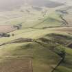
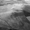
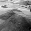
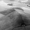
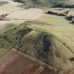
Hill Of Newleslie


Fort (Period Unassigned)
Site Name Hill Of Newleslie
Classification Fort (Period Unassigned)
Alternative Name(s) Hill Of New Leslie; Cotetown
Canmore ID 17638
Site Number NJ52NE 31
NGR NJ 584 254
Datum OSGB36 - NGR
Permalink http://canmore.org.uk/site/17638


- Council Aberdeenshire
- Parish Leslie (Gordon)
- Former Region Grampian
- Former District Gordon
- Former County Aberdeenshire
NJ52NE 31 584 254
See also NJ52NE 77.
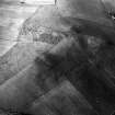
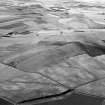
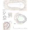
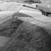
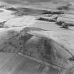
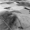
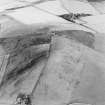
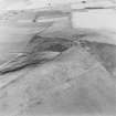
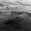
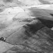
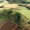
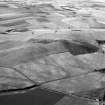
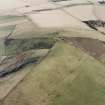
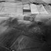
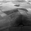
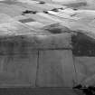
(Originally classified as fort). Discovered in the course of aerial survey work by Aberdeen Archaeological Surveys, consists today of a bank and internal quarry ditch surrounding the hilltop (altitude 285m) on three sides. On the S side no trace now remains due to ploughing associated with reseeding. The earthen bank measures between 4m and 5m wide, and is 0.5m high. It may be rock cut at the E end. The internal quarry ditch is between 3m and 4m wide and 0.4m deep. No entrance was detected. The fort measures 359m E-W by 175m transversely, making it one of the largest in the region, at over 4 hectares.
W Watt 1983.
Location cited as NJ 583 253 and classified as hill enclosure.
NMRS, MS/712/17.
Classified by GRC/AAS as (incomplete) hill fort. Threatened by (forestry) ploughing.
NMRS, MS/712/19.
(Classified as hill enclosure). Air photographs: AAS/94/11/G22/11-15.
NMRS, MS/712/21.
(Classified as hill enclosure). Air photographs: AAS/00/02/G3/3-8 and AAS/00/02/CT.
NMRS, MS/712/100.
Scheduled as 'Hill of Newleslie, hillfort, 400m N of Cotetown... a defended hilltop enclosure of prehistoric date, visible as cropmarks on oblique aerial photographs, and as field remains.'
Information from Historic Scotland, scheduling document dated 18 October 2006.
Field Visit (13 September 2000)
This fort, which is situated on the summit of the Hill of Newleslie, is roughly oval on plan, measuring 370m from E to W by a maximum of about 170m transversely at its slightly broader E end within the heavily eroded defences. These are situated some way down the flanks of the hill and appear to comprise twin banks accompanied by both an internal and a medial ditch. On the N side of the hill the banks have been reduced to low outer-facing scarps, which continue (with gaps) around to the W until they peter out. Thereafter, apart from a length of scarp about 95m long, nothing is visible of the earthworks on the S side of the fort until the E end is reached. Here, both banks and ditches are visible on the SE, but on the E only traces of the inner bank can be detected as it continues to the NE as a mere scarp. Where best preserved (on the SE and N), the inner bank measures up to 5.5m in thickness by 0.2m in height. The medial ditch, measuring 3.5m broad, separates the inner from the outer bank which measures 2.6m thick by 0.1m high, respectively. However, the inner ditch on the SE, which was presumably a source of material for the inner bank rather than a defensive feature, measures up to 3.7m in breadth. No entrances were positively identified on the date of visit.
Visited by RCAHMS (JRS, SPH) 13 September 2000.
Archaeological Evaluation (18 July 2009 - 31 July 2009)
NJ 584 254 and NJ 8025 2570 The RCAHMS volume on Strathdon identified six types of hillforts based on size and defensive systems. However none of the sites have been dated. The Hillforts of Strathdon Project aims to recover dating evidence from one of each of the six classes of hillfort.
Two sites were examined during the third and final season of fieldwork, 18–31 July 2009. Five trenches were dug at Hill of Barra and two trenches were opened at Hill of Newleslie. All the features identified in the trenches were excavated and recorded. The excavations at Hill of Newleslie indicated that there was no significant depth of deposits, that the site had been heavily affected by roots (probably gorse) and that their subsequent burning had spread modern root charcoal through the soil. Conversely, the work at Hill of Barra revealed significant quantities of charcoal and artefacts including possible Grooved Ware. An internal rock cut ring-groove feature was also identified.
Archive: RCAHMS (intended)
Funder: The CBA
Murray Cook, Rob Engl, Lindsay Dunbar, Hana Kdolska and Stefan Sagrott – Oxford Archaeology North
Note (10 April 2015 - 18 May 2016)
This large hilltop enclosure is situated on the Hill of Newleslie, a long ridge that rises up behind the farm of New Leslie. The enclosure takes in the crest of the ridge extending W from the summit and measures about 355m from E to W by a maximum of 160m transversely within a low bank with an external ditch and occasional traces of a counterscarp bank. Some sectors have been virtually levelled by ploughing, but where best preserved the bank is up to 4m in thickness by a maximum of 0.5m in height and the ditch 4m in breadth by 0.4m in depth. The greater part of the interior has been cultivated with varying degrees of intensity, but even where least disturbed in the overgrown NE sector it is featureless. No clear evidence of an entrance has been observed either.
Information from An Atlas of Hillforts of Great Britain and Ireland – 18 May 2016. Atlas of Hillforts SC2950

