
Kylieford


Ring Ditch (Period Unassigned)
Site Name Kylieford
Classification Ring Ditch (Period Unassigned)
Canmore ID 17635
Site Number NJ52NE 29
NGR NJ 5703 2769
Datum OSGB36 - NGR
Permalink http://canmore.org.uk/site/17635


- Council Aberdeenshire
- Parish Kennethmont
- Former Region Grampian
- Former District Gordon
- Former County Aberdeenshire
NJ52NE 29 5705 2770.
Noted during aerial reconnaisance.
Aberdeen Archaeological Surveys 1980.
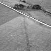
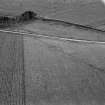
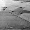
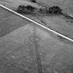
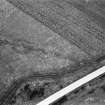
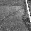
(Location cited as NJ 570 277). Kylieford. Air photography (AAS/78/9/R7/23) has recorded the cropmark of a ring-ditch in arable ground at an altitude of 200m OD.
NMRS, MS/712/36.
The cropmarks of this ring-ditch have been revealed by aerial photography (GRC/AAS 1978) on the leading edge of a low terrace on the N bank of an un-named stream about 190m SE of Kylieford farmsteading (NJ52NE 94). The ring-ditch measures about 10m in diameter within a ditch up to 2m in breadth.
Visited by RCAHMS (JRS, IF), 23 February 1996.

