|
Photographs and Off-line Digital Images |
AB 5862 PO |
Records of Aberdeen Aerial Surveys, Aberdeen, Scotland |
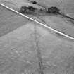
Kylieford, ring-ditch: aerial view. |
1978 |
Item Level |
|
|
Manuscripts |
MS 712/36 |
Records of Aberdeenshire Archaeology Service, Aberdeen, Scotland |
Photocopies of updates to Aberdeenshire Archaeological Service (formerly Grampian Regional Council) SMR, relating to sites, finds and monuments within area of former Grampian Region, received April 1997 (with supplementary information and covering letter). |
1997 |
Item Level |
|
 |
On-line Digital Images |
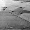
SC 1011704 |
Records of Aberdeen Aerial Surveys, Aberdeen, Scotland |
General oblique aerial view centred on the cropmarks of a ring ditch at Kylieford, looking to the NW. |
22/8/1978 |
Item Level |
|
 |
On-line Digital Images |
SC 1011705 |
Records of Aberdeen Aerial Surveys, Aberdeen, Scotland |
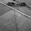
Oblique aerial view centred on the cropmarks of a ring ditch at Kylieford, looking to the ESE. |
22/8/1978 |
Item Level |
|
 |
On-line Digital Images |
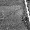
SC 1011706 |
Records of Aberdeen Aerial Surveys, Aberdeen, Scotland |
Oblique aerial view centred on the cropmarks of a ring ditch at Kylieford, looking to the NNW. |
22/8/1978 |
Item Level |
|
 |
On-line Digital Images |
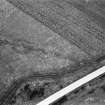
SC 1011707 |
Records of Aberdeen Aerial Surveys, Aberdeen, Scotland |
Oblique aerial view centred on the cropmarks of a ring ditch at Kylieford, looking to the S. |
22/8/1978 |
Item Level |
|
 |
On-line Digital Images |
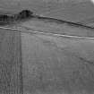
SC 1011708 |
Records of Aberdeen Aerial Surveys, Aberdeen, Scotland |
Oblique aerial view centred on the cropmarks of a ring ditch at Kylieford, looking to the SSE. |
22/8/1978 |
Item Level |
|
 |
On-line Digital Images |
SC 1937959 |
Records of Aberdeen Aerial Surveys, Aberdeen, Scotland |
Kylieford, ring-ditch: aerial view. |
1978 |
Item Level |
|
 |
On-line Digital Images |
SC 2372914 |
Records of the Ordnance Survey, Southampton, Hampshire, England |
Kylieford, NJ52NE 29, Ordnance Survey index card, Recto |
c. 1958 |
Item Level |
|
 |
On-line Digital Images |
SC 2372915 |
Records of the Ordnance Survey, Southampton, Hampshire, England |
Kylieford, NJ52NE 29, Ordnance Survey index card, Recto |
c. 1958 |
Item Level |
|
 |
On-line Digital Images |
SC 2372916 |
Records of the Ordnance Survey, Southampton, Hampshire, England |
Kylieford, NJ52NE 29, Ordnance Survey index card, Recto |
c. 1958 |
Item Level |
|


