
Pricing Change
New pricing for orders of material from this site will come into place shortly. Charges for supply of digital images, digitisation on demand, prints and licensing will be altered.
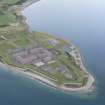
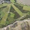
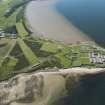
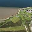
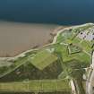
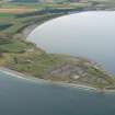
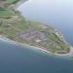
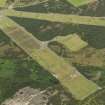
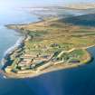
Fort George, Rifle Ranges


Firing Range(S) (First World War), Firing Range (19th Century) - (20th Century), Firing Range (Second World War)
Site Name Fort George, Rifle Ranges
Classification Firing Range(S) (First World War), Firing Range (19th Century) - (20th Century), Firing Range (Second World War)
Alternative Name(s) Skinner Road; Adams Road
Canmore ID 173654
Site Number NH75NE 27.02
NGR NH 7700 5700
NGR Description Centred NH 7700 5700
Datum OSGB36 - NGR
Permalink http://canmore.org.uk/site/173654


- Council Highland
- Parish Ardersier
- Former Region Highland
- Former District Inverness
- Former County Inverness-shire
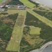
The location and layout of the firing ranges has changed since they were first mapped, in 1870 but they seem to have been in continuous use until the present day. They would certainly have been used during the First World War.
The rifle ranges appear first on the 2nd edition OS map of the area around the Fort.
Information from HS/RCAHMS World War One Audit Project (GJB) 30 September 2013.
NH75NE 27.02 centred 7700 5700
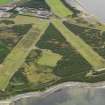
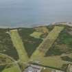
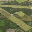
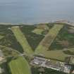
To the E of Fort George is the military training area within which are several rifle ranges. The ranges consist of firing points and target areas all of which are still in use by the army.
On the E side of the rifle ranges are two lengths of concrete wall which could possibly be sections of practice 'Atlantic Wall'.
J Guy 2000; NMRS MS 810/10, Vol.2, 128, Vol3, 40-1
Project (March 2013 - September 2013)
A project to characterise the quantity and quality of the Scottish resource of known surviving remains of the First World War. Carried out in partnership between Historic Scotland and RCAHMS.

