
Following the launch of trove.scot in February 2025 we are now planning the retiral of some of our webservices. Canmore will be switched off on 24th June 2025. Information about the closure can be found on the HES website: Retiral of HES web services | Historic Environment Scotland
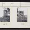
Pitlurg Castle


Dovecot (18th Century), Tower House (Medieval)
Site Name Pitlurg Castle
Classification Dovecot (18th Century), Tower House (Medieval)
Alternative Name(s) Pitlurg Doocot
Canmore ID 17301
Site Number NJ44NW 1
NGR NJ 43578 45563
Datum OSGB36 - NGR
Permalink http://canmore.org.uk/site/17301


- Council Moray
- Parish Keith
- Former Region Grampian
- Former District Moray
- Former County Banffshire
Pitlurg Castle, post 1539. Courtyard plan with circular tower on rock foundations, now doocot. Pitlurg Gordons descended from Jock o' Scudargue, near Rhynie, and held property until 1724. A descendent, General Gordon, 1815, took the name for his estate of Leask and Birness, Formartine.
Taken from "Aberdeenshire: Donside and Strathbogie - An Illustrated Architectural Guide", by Ian Shepherd, 2006. Published by the Rutland Press http://www.rias.org.uk

NJ44NW 1 43578 45563
(NJ 4358 4556) Pitlurg Castle (NR)
OS 6" map, (1959).
For adjacent Mains of Pitlurg steading, see NJ44NW 14.
Not to be confused with country house of Pitlurg (NK 0263 3306), for which see NK03SW 30.00.
Pitlurg Castle, in ruins in 1879, probably dates from the late 16th century.
A Jervise 1879.
The Castle of Pitlurg was surrounded by a deep ditch. There was a tower on the NE angle, and a long range of buildings on the west. The house was partly habitable c. 1749.
J A Cameron 1849; J F S Gordon 1880.
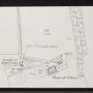
Only the circular tower remains of a probable 'L' or 'Z' shaped building. This is now unroofed, and has been utilised as a dovecot, but sufficient architectural details remain to determine its 16th century date. No sign of a ditch, or of buildings to the W, but that there has been a substantial structure to the E, since quarried away, is indicated by a rebuilt doorway, and the remains of a stone staircase leading to the second floor of the tower in its SE arc. Traces of building footings to the S of the tower where OS 25" map, Banffshire, shows two rectangular buildings, are probably the remains of modern farm buildings.
Re-surveyed at 1/2500.
Visited by OS (AA), 5 July 1967.
Condition unchanged.
Visited by OS (ISS), 12 December 1972.

