Pricing Change
New pricing for orders of material from this site will come into place shortly. Charges for supply of digital images, digitisation on demand, prints and licensing will be altered.
Garran Burn
Stone Circle (Neolithic) - (Bronze Age)
Site Name Garran Burn
Classification Stone Circle (Neolithic) - (Bronze Age)
Alternative Name(s) Bowman Hillock, Bowman-hillock
Canmore ID 17259
Site Number NJ43NE 5
NGR NJ 48092 39859
Datum OSGB36 - NGR
Permalink http://canmore.org.uk/site/17259
- Council Aberdeenshire
- Parish Huntly
- Former Region Grampian
- Former District Gordon
- Former County Aberdeenshire
NJ43NE 5 4808 3986.
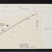
At NJ 4808 3986 are the remains of a stone circle (information from Mr J Gordon, Wellheads, Huntly). The circle is situated in a rather boggy area now overgrown with marsh grass, and only four stones (varying between 0.6m and 1.0m in height) appear to survive in situ. These are set with their longer axis at right angles to the circumference. Other stones lie prostrate and an upright near the centre of the circle may be intrusive. The NW segment of the circle is crossed by a ditch and fence on the NW side of which the stones have been removed during field clearance.
Visited by OS (ISS) 7 December 1972.
Field Visit (15 February 2018)
This stone circle is situated in waste ground about 15m WNW of the junction of the minor public road with another leading E to Wellheads. Only three grey granite orthostats survive and (pace Ian S Sainsbury of the OS) these describe the W arc of a ring measuring about 19m in diameter. The most northerly stands upright and measures 0.87m high, while its two companions to the S lean steeply SE and N respectively. Much of the interior has been eroded and is occupied by thorn scrub, while there are scrappy SE-facing lynchets resulting from ploughing to the ring’s south. The boulders to the W are either field clearance or have been exhumed from the neighbouring ditch.
Visited by HES, Survey and Recording (ATW, AMcC), 15 February 2018.
Measured Survey (15 February 2018)
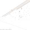
HES surveyed Garran Burn stone circle with GNSS on 15 February 2018. The linework was drawn-up in vector graphics software to produce at a plan of the site at a scale of 1:250.


